Krempel (Dithmarschen)
| coat of arms | Germany map | |
|---|---|---|

|
Coordinates: 54 ° 19 ′ N , 9 ° 2 ′ E |
|
| Basic data | ||
| State : | Schleswig-Holstein | |
| Circle : | Dithmarschen | |
| Office : | Parish land parishes of Eider | |
| Height : | 2 m above sea level NHN | |
| Area : | 4.83 km 2 | |
| Residents: | 606 (Dec. 31, 2019) | |
| Population density : | 125 inhabitants per km 2 | |
| Postal code : | 25774 | |
| Area code : | 04882 | |
| License plate : | HEI, MED | |
| Community key : | 01 0 51 061 | |
| Office administration address: | Kirchspielsschreiber-Schmidt-Straße 1 25779 Hennstedt |
|
| Website : | ||
| Mayor : | Ronald Petersen ( SPD ) | |
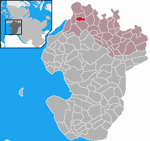
| Location of the municipality of Krempel in the Dithmarschen district | ||
Krempel is a municipality in the Dithmarschen district in Schleswig-Holstein .
geography
location
The community is located on the Lunden Spit in the immediate vicinity of the central town of Lunden in the north of Dithmarschen .
Neighboring communities
Neighboring communities are the communities of Lunden, Sankt Annen , Schlichting , Rehm-Flehde-Bargen and Groven (all in the Dithmarschen district), starting clockwise to the north .
history
Krempel was first mentioned in a document in 1231. It is unclear whether it was the Celts who founded Cremböl, from which today's Krempel arose. While Lunden experienced a glorious time with flourishing trade, Krempel developed into an agricultural village in the shadow of the neighboring community. Even in historical times, most farmers were dependent on a sideline in the marshes or in the moor to secure their livelihood. Today the community has changed from a sand dune to a modern residential community.
On April 1, 1934, the parish Lunden was dissolved. All of their villages, village communities and peasant communities became independent communities / rural communities, including Krempel.
politics
Community representation
Of the nine seats in the municipal council has SPD since the local elections in 2013 five seats and the voter community WHC four.
coat of arms
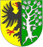
Blazon : “Split between gold and green. In front a half, red armed black eagle at the crack, behind a rooted silver pine. "
In contrast to the unrestrained Nordic heraldic lion of the Danish, Schleswig and Holstein rulers, who had often threatened the freedom of Dithmarschens , the eagle is supposed to evoke the parish's vigilance and defensiveness . The half imperial eagle is also intended to visually demonstrate that, similar to the free imperial cities, one only feels subordinate and belonging to the German Empire and its emperors , and not to any princes. The gnarled pine symbolizes the struggle of the inhabitants to assert themselves on the barren dune (recently extensive plantings of coniferous forest in the municipality of Krempel) and to make the landscape (once lake and sea) arable and fertile in both the west and east.
Economy and Infrastructure
traffic
The municipality of Krempel is located directly on the Hamburg - Westerland railway line . The A 23 is easy to reach via the B 5 motorway slip road at Hemme and Karolinenkoog , approx. 6 km away .
Established businesses
Numerous craft and service companies are based in Krempel, such as B. a car workshop, construction and civil engineering company, heating and plumbing company and an electrical installation company.
education
For the children of the community there is a primary school in the neighboring village of Lunden, as well as the secondary school, the special needs school and the kindergarten. High schools are located in Heide or Husum and are easily accessible by bus and train. A train station is about 1 km away in Lunden.
Personalities
- Friedrich Jansen (born September 5, 1883 in Krempel, † May 15, 1945 in Meldorf), wine merchant and murder victim
Web links
- Municipality of Krempel (joint website with the municipalities of Lunden and Lehe)
- Municipality of Krempel at the parish regional authorities of Eider
Individual evidence
- ↑ North Statistics Office - Population of the municipalities in Schleswig-Holstein 4th quarter 2019 (XLSX file) (update based on the 2011 census) ( help on this ).
- ↑ State Statistical Office Schleswig-Holstein (Ed.): The population of the communities in Schleswig-Holstein 1867-1970 . State Statistical Office Schleswig-Holstein, Kiel 1972, p. 251 .
- ↑ Final result of the local elections 2013 ( page no longer available , search in web archives ) Info: The link was automatically marked as defective. Please check the link according to the instructions and then remove this notice.
- ↑ Schleswig-Holstein's municipal coat of arms


