| Surname
|
image
|
Identifier
|
circle
|
details
|
position
|
Area
hectares
|
date
|
|
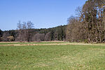
Ampfrachsee
|
BW
|
NSG-00564.01
WDPA: 318115
|
Ansbach district
|
Schnelldorf
Structurally rich wetland habitat with extensive meadows.
|
⊙
|
36.09
|
1982
|
|
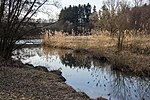
Ellenbach
|
BW
|
NSG-00588.01
WDPA: 318338
|
Ansbach district
|
Voggendorf
Mowing, wet and litter meadows, wet fallow and alder forest.
|
⊙
|
27.74
|
1940
|
|
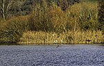
Wet areas at the Hammerschmiedsweiher
|
BW
|
NSG-00215.01
WDPA: 163051
|
Ansbach district
|
Dambach
Vermoort valley area.
|
⊙
|
19.34
|
1993
|
|
Großlellenfelder Moor
|
BW
|
NSG-00316.01
WDPA: 163384
|
Ansbach district
|
Großlellenfeld
litter meadows, intermediate moor and swamp forest areas.
|
⊙
|
10.77
|
1987
|
|
Heglauer Wasen
|
BW
|
NSG-00105.01
WDPA: 81845
|
Ansbach district
|
Heglau
marshland and pipe grass meadows.
|
⊙
|
5.4
|
1977
|
|
Kappelwasen
|
BW
|
NSG-00104.01
WDPA: 82040
|
Ansbach district
|
Ornbau
biotope complex with a spacious wet meadow landscape.
|
⊙
|
11.71
|
1977
|
|
Karrachsee
|
BW
|
NSG-00370.01
WDPA: 164030
|
Ansbach district
|
Windelsbach
Diverse complex of wet biotopes with numerous spring outlets.
|
⊙
|
19.88
|
1990
|
|
Kühberg near Gastenfelden
|

|
NSG-00223.01
WDPA: 164280
|
Ansbach district
|
Gastenfelden
Magerrasen.
|
⊙
|
17.31
|
1984
|
|
Moosteile at the Klarweiher
|
BW
|
NSG-00211.01
WDPA: 164691
|
Ansbach district
|
Dennenlohe fen
soils.
|
⊙
|
9.7
|
1984
|
Wet meadows Lierenfeld 
|
|
NSG-00179.01
WDPA: 82207
|
Ansbach , district of Donau-Ries
|
Fürnheim
Nasswiesen.
Ansbach district = 6.61 ha
Donau-Ries district = 0.07 ha
|
⊙
|
6.68
|
1983
|
|
Sheep herding around Kirnberg
|
BW
|
NSG-00446.01
WDPA: 165353
|
Ansbach district
|
Kirnberg poor
grassland.
|
⊙
|
47.54
|
1993
|
|
Schandtauberhöhle
|
BW
|
NSG-00205.01
WDPA: 165361
|
Ansbach district
|
Bettenfeld Large
water-bearing cave.
|
⊙
|
11.98
|
1984
|
|
Cadolzhofen dry lawn guard
|
BW
|
NSG-00244.01
WDPA: 165963
|
Ansbach district
|
Cadolzhofen
Dry grass interspersed with trees.
|
⊙
|
13.55
|
1985
|
|
Bird sanctuary Großer and Kleiner Lindleinsee
|

|
NSG-00378.01
WDPA: 166066
|
Ansbach district
|
Schweinsdorf
Flat pond banks with a wide reed belt.
|
⊙
|
28.58
|
1990
|
|
Wildlife sanctuary and Gais pond
|
BW
|
NSG-00204.01
WDPA: 166078
|
Ansbach district
|
Dinkelsbühl
pond with special importance for the bird world.
|
⊙
|
33.9
|
1984
|
|
Scheerweiher area near Schalkhausen
|

|
NSG-00368.01
WDPA: 165372
|
Ansbach
|
Ansbach
Flat pond with surrounding extensive pond rushes, cattails and reeds.
|
⊙
|
52.95
|
1990
|
|
Brucker Lache
|

|
NSG-00199.01
WDPA: 162592
|
gain
|
Acquiring
wet forests
|
⊙
|
114.17
|
1964
|
|
Parade ground
|

|
NSG-00578.01
WDPA: 318380
|
gain
|
Achievement
change from sandy grasslands, dense grass corridors, open sand areas and groups of trees.
|
⊙
|
24.74
|
2000
|
|
Ziegenanger wet meadows near Neuhaus
|

|
NSG-00340.01
WDPA: 163088
|
Erlangen-Höchstadt
|
Adelsdorf
Extensive flat meadow location in the middle of an open agricultural landscape.
|
⊙
|
34.83
|
1988
|
|
Chain of ponds north of Bösenbechhofen
|

|
NSG-00754.01
WDPA: 555560673
|
Erlangen-Höchstadt
|
Höchstadt an der Aisch
Diverse pond landscape and alluvial forest. Occurrence of the crested newt and the great moss maiden .
|
⊙
|
23.06
|
2012
|
|
Tennenloher Forest
|

|
NSG-00483.01
WDPA: 165851
|
Erlangen , Erlangen-Höchstadt
|
Forst Tennenlohe
Characteristic section of the Sebalder Reichswald.
|
⊙
|
955.95
|
1994
|
|
Bird sanctuary pond area near Mohrhof
|

|
NSG-00167.01
WDPA: 82807
|
Erlangen-Höchstadt
|
Poppenwind
Extensive pond complex with almost 100 ponds.
|
⊙
|
128.87
|
1982
|
|
Pond area near Krausenbechhofen
|

|
NSG-00314.01
WDPA: 166208
|
Erlangen-Höchstadt
|
Krausenbechhofen
Typical groups of ponds in the Aischgrund.
|
⊙
|
26.25
|
1987
|
|
Wilderness on the Rathsberg
|

|
NSG-00514.01
WDPA: 166315
|
Forchheim , Erlangen-Höchstadt
|
Rathsberg
Near-natural deciduous and mixed forests.
|
⊙
|
26.60
|
2015
|
|
Chain of ponds near Oberreichenbach
|
BW
|
NSG-00396.01
WDPA: 166211
|
Fürth district
|
Oberreichenbach
pond chain.
|
⊙
|
9.67
|
1992
|
|
Hainberg
|

|
NSG-00493.01
WDPA: 163484
|
Nuremberg , Fürth district
|
Oberasbach
Largest contiguous sandy grassland area in Northern Bavaria.
Fürth district = 196.73 ha
Nuremberg = 14.8 ha
|
⊙
|
211.53
|
1995
|
|
Gypsum cave Höllern and gypsum hill "Seven Buckles"
|

|
NSG-00278.01
WDPA: 163252
|
Neustadt an der Aisch-Bad Windsheim district
|
Markt Nordheim
Two extensive cave systems and special flora and fauna.
|
⊙
|
10.16
|
1986
|
|
Graefholz and Dachsberge
|

|
NSG-00299.01
WDPA: 163300
|
Neustadt an der Aisch-Bad Windsheim district
|
Bad Windsheim In terms of
regional history, particularly valuable forest in Bavaria.
|
⊙
|
350.36
|
1986
|
|
Holzöd near Ippesheim
|
BW
|
NSG-00224.01
WDPA: 163783
|
Neustadt an der Aisch-Bad Windsheim district
|
Ippesheim
Species-rich semi-arid grassland.
|
⊙
|
5.88
|
1984
|
|
Guard at Gigert
|
BW
|
NSG-00420.01
WDPA: 163841
|
Neustadt an der Aisch-Bad Windsheim district
|
Seenheim Striking
juniper heaths.
|
⊙
|
39.47
|
1992
|
|
Külsheim gypsum hill
|

|
NSG-00181.01
WDPA: 164297
|
Neustadt an der Aisch-Bad Windsheim district
|
Kühlsheim gypsum hills
and extensively used rough meadows.
|
⊙
|
8.37
|
1983
|
|
Rammelsee and Kleiner Schimmelsteig
|
BW
|
NSG-00183.01
WDPA: 82364
|
Neustadt an der Aisch-Bad Windsheim district
|
Uttenhofen
mixed oak forests with a historical form of forest use.
|
⊙
|
39.53
|
1983
|
|
Weiherboden near Anfelden
|
BW
|
NSG-00457.01
WDPA: 166207
|
District Neustadt an der Aisch-Bad Windsheim , Ansbach
|
Oberdachstetten
Abandoned pond with surrounding meadows.
Neustadt an der Aisch district = 7.24 ha
Ansbach district = 1.37 ha
|
⊙
|
8.62
|
1993
|
|
Sand pits at Föhrenbuck
|

|
NSG-00407.01
WDPA: 165316
|
Nuremberg
|
Nuremberg
Former sand pits.
|
⊙
|
21.93
|
1992
|
|
Pegnitztal East
|
|
NSG-00758.01
|
Nuremberg
|
Nuremberg
Near-natural section of the Pegnitz Valley with sandy grassland, extensive grassland, floodplain and other forests.
|
⊙
|
221
|
2018
|
|
Lichen and pine forests south of Leinburg
|

|
NSG-00570.01
WDPA: 318401
|
District of Nürnberger Land
|
Leinburg
Unique natural area with sand dunes, lichen and pine forests characterized by drought.
|
⊙
|
834.0803
|
1950
|
|
Schwarzach breakthrough
|

|
NSG-00300.01
WDPA: 165487
|
District of Nürnberger Land , District of Roth
|
Schwarzenbruck
Räthsandsteinschlucht with surf caves, abundance of mosses, alder - alluvial forests and on the slopes mixed forests of beech, pine and spruce trees.
Area distribution:
District of Nürnberger Land = 25.04ha
District of Roth = 13.23
|
⊙
|
38.27
|
1936
|
|
Schwarzenbrucker Moor
|
|
NSG-00415.01
WDPA: 165504
|
District of Nürnberger Land
|
Schwarzenbruck
One of the few moors in Middle Franconia. Silting complex of near-natural ponds with floating leaf and underwater vegetation.
|
⊙
|
9.8906
|
1982
|
|
Upper Molsberg Valley
|
|
NSG-00227.01
WDPA: 164884
|
District of Nürnberger Land
|
Happurg
Natural canyon forests with spring slopes, grazed grasslands, juniper bushes, meadows, tall herbaceous vegetation and calcareous debris fields.
|
⊙
|
17.4252
|
1984-12-04
|
|
Rinntal near Alfeld
|

|
NSG-00579.01
WDPA: 318994
|
District of Nürnberger Land
|
Alfeld
Typical Jura rock valley on the Alb plateau.
|
⊙
|
32.8211
|
2000-09-08
|
|
Schottental near Heldmannsberg
|

|
NSG-00579.01
WDPA: 318994
|
District of Nürnberger Land
|
Pommelsbrunn
valley floor with the typical character of a Hutanger .
|
⊙
|
42.0441
|
1996-09-25
|
|
Wetland and sandy grasslands near Speikern
|
BW
|
NSG-00242.01
WDPA: 163062
|
District of Nürnberger Land
|
Ottensoos
Varied habitat made up of dry sand and wet biotopes.
|
⊙
|
10.4915
|
1996
|
|
Pegnitzau between Ranna and Michelfeld
|
|
NSG-00548.01
WDPA: 318939
|
District of Nürnberger Land , District of Amberg-Sulzbach , District of Bayreuth
|
Neuhaus , Auerbach , Pegnitz
valley meadows.
Area distribution:
District of Nürnberger Land = 99.34ha
District Amberg-Sulzbach = 79.83ha
District Bayreuth = 19.24ha
|
⊙
|
198.71
|
1998
|
|
Stream and gorge forest near Untermässing
|

|
NSG-00447.01
WDPA: 162312
|
District of Roth
|
Undermässing
spring outflows with tufa formations
|
⊙
|
12.2
|
1987
|
|
Kuhbachtal near Hausen
|

|
NSG-00502.01
WDPA: 164278
|
District of Roth
|
Röckenhofen
Typical landscape section of the Albtrauf
|
⊙
|
48.8
|
1995
|
|
Northwest bank of the Rothsee main dam
|

|
NSG-00541.01
WDPA: 318868
|
District of Roth
|
Roth
silting area with shallow water zones and several islands
|
⊙
|
47.24
|
1998
|
|
Reservoir root of the Rothsee
|
|
NSG-00404.01
WDPA: 165657
|
District of Roth
|
Allersberg alluvial
forests, open water areas, inaccessible islands and siltation area
|
⊙
|
45.19
|
1992
|
|
Thalach meadows
|
BW
|
NSG-00426.01
WDPA: 165872
|
District of Roth
|
Thalmässing
Near-natural stream course and abandoned, well-kept areas
|
⊙
|
12.64
|
1992
|
|
Kauerlacher Weiher bird sanctuary
|
BW
|
NSG-00276.01
WDPA: 166073
|
District of Roth
|
Karm
Still water close to nature
|
⊙
|
40.69
|
1986
|
|
Schwarzachwiesen bird sanctuary near Freystadt
|
BW
|
NSG-00331.01
WDPA: 166077
|
District of Roth , District of Neumarkt in the Upper Palatinate
|
Ebenried , Freystadt
Large meadow complex with partially extensively used meadows, which provides an important habitat for sensitive, meadow-breeding bird species.
District of Neumarkt in the Upper Palatinate : 20.83 ha,
District of Roth : 21.41 ha
|
⊙
|
42.24
|
1988
|
|
Dredging pond between Bechhofen and Gauchsdorf
|
BW
|
NSG-00757.01
|
District of Roth
|
Abenberg , Büchenbach
Abandoned sand mining sites. Habitats of a species-rich flora and fauna.
|
⊙
|
35.54
|
2017
|
|
Alluvial forest near Westheim
|
BW
|
NSG-00475.01
WDPA: 162305
|
Weissenburg-Gunzenhausen district
|
Westheim (Middle Franconia)
Wet forest area, which is characterized by black alder and ash swamp forests.
|
⊙
|
50.33
|
1979
|
|
Brombachmoor
|
BW
|
NSG-00194.01
WDPA: 81462
|
Weissenburg-Gunzenhausen district
|
Langlau
Moor in a hollow valley covered by alder forests, alluvial forests and small ponds.
|
⊙
|
3.94
|
1995
|
|
Bookkeeping at Markt Berolzheim
|
|
NSG-00465.01
WDPA: 162621
|
Weissenburg-Gunzenhausen district
|
Berolzheim market
semi-dry grassland with grazing sheep.
|
⊙
|
31.13
|
1986
|
|
Oak-hornbeam forest Laubenbuch near Rothenstein
|

|
NSG-00266.01
WDPA: 162883
|
Weissenburg-Gunzenhausen district
|
Rothenstein
Historical forest management in the form of a medium forest.
|
⊙
|
20.38
|
1985
|
|
Grafenmühle
|

|
NSG-00577.01
WDPA: 318456
|
Weissenburg-Gunzenhausen district
|
Langlau
Open water areas and dry spruce and pine forests.
|
⊙
|
88.52
|
2000
|
|
Peninsula in the Kleiner Brombachsee
|
|
NSG-00344.01
WDPA: 163494
|
Weissenburg-Gunzenhausen district
|
Langlau
Species-rich, poor meadows surrounded by different biotopes.
|
⊙
|
42.06
|
1989
|
|
Dry Jura slope with the rock group "Twelve Apostles"
|

|
NSG-00216.01
WDPA: 163959
|
Weissenburg-Gunzenhausen district
|
Solnhofen
series of rock towers.
|
⊙
|
15.12
|
1984
|
|
Märzenbecherwald near Ettenstatt
|

|
NSG-00337.01
WDPA: 164577
|
Weissenburg-Gunzenhausen district
|
Ettenstatt
Largest occurrence of the spring knot flower in the Weißenburg-Gunzenhausen district.
|
⊙
|
11.82
|
1988
|
|
Spring horizons and grasslands on the Albtrauf near Niederhofen
|

|
NSG-00275.01
WDPA: 165066
|
Weissenburg-Gunzenhausen district
|
Niederhofen
spring outlets and fens.
|
⊙
|
44.59
|
1986
|
|
Sawmill
|

|
NSG-00580.01
WDPA: 319037
|
District of Weissenburg-Gunzenhausen , district Roth
|
Absberg , Enderndorf , Kalbensteinberg
flat water zone and adjacent open water areas.
Weissenburg-Gunzenhausen district = 19.44 ha
Roth district = 12.92 ha
|
⊙
|
32.35
|
2000
|
|
Schambachried
|
|
NSG-00099.01
WDPA: 82506
|
Weissenburg-Gunzenhausen district
|
Schambach
Rare limestone flat moor.
|
⊙
|
6.88
|
1973
|
|
Reservoir root of the Igelsbachsee
|

|
NSG-00345.01
WDPA: 165656
|
Weissenburg-Gunzenhausen district
|
Absberg
biotope complex made up of silting societies, alder forest remains and fallow land.
|
⊙
|
25.25
|
1989
|
|
Stone channel near Wolfsbronn
|

|
NSG-00213.01
WDPA: 82630
|
Weissenburg-Gunzenhausen district
|
Meinheim
Moss-covered limestone turf channel.
|
⊙
|
6.53
|
1984
|
|
Bird sanctuary shallow water and island zone in the Altmühlsee
|
|
NSG-00311.01
WDPA: 166070
|
Weissenburg-Gunzenhausen district
|
Gunzenhausen , Muhr am See
"Vogelinsel" with flat islands, mud banks and long shorelines
|
⊙
|
201.54
|
1987
|
| Legend for nature reserve
|


