
Erlangen-Höchstadt district
| coat of arms | Germany map |
|---|---|

|

Coordinates: 49 ° 38 ' N , 10 ° 55' E |
| Basic data | |
| State : | Bavaria |
| Administrative region : | Middle Franconia |
| Administrative headquarters : | gain |
| Area : | 564.66 km 2 |
| Residents: | 137,262 (Dec. 31, 2019) |
| Population density : | 243 inhabitants per km 2 |
| License plate : | ERH, HÖS |
| Circle key : | 09 5 72 |
| NUTS : | DE257 |
| Circle structure: | 25 municipalities |
| Address of the district administration: |
Nägelsbachstrasse 1 91052 Erlangen, Germany |
| Website : | |
| District Administrator : | Alexander Tritthart ( CSU ) |
| Location of the district of Erlangen-Höchstadt in Bavaria | |
  |
|
The district of Erlangen-Höchstadt is located in the north of the Bavarian administrative district of Middle Franconia . The district is a member of the Nuremberg Metropolitan Region .
geography
location
The district area essentially comprises the Middle Franconian Basin with extensive pine forests. In the east, the Regnitz and the Main-Danube Canal flow through the district in a north-south direction. In the north, the Aisch , a tributary of the Regnitz, flows roughly in a west-east direction through the district. Here there is a pond landscape in which fish farming is carried out. In the east of the district the landscape rises to the Alb foreland. In the municipality Vestenbergsgreuth in the west of the county, the center is franc (at 49.7173 ° N , 10.6349 ° O ).
The narrow point ( wasp waist ) between the eastern and western parts of the district is only 683.43 meters wide. It is bordered by the Forchheim district in the north (the municipality of Langensendelbach with the Bräuningshof district ), and the city of Erlangen in the south.
Neighboring areas
The district borders clockwise, starting in the north, on the districts of Bamberg , Forchheim and Nürnberger Land , on the independent cities of Nuremberg and Erlangen and on the districts of Fürth and Neustadt an der Aisch-Bad Windsheim .
history

Until 1810
Around 1000 places in what would later become the district were first mentioned in a document. In 1413 the water pumping wheels, some of which are still in use today, were first documented on the Regnitz. The first margravial war took place in 1449/1450 and the Second Margrave War from 1552 to 1555 , during which there was numerous devastation.
In 1715 the construction of Hemhofen Castle began. At the height of water wheel use in 1805, around 190 water wheels were in use on the Regnitz between Fürth and Forchheim .
Regional courts
In 1812, the district court districts of Erlangen , Herzogenaurach and Höchstadt an der Aisch were set up in what is now the district , all of which belonged to the Rezat district . At the same time, Erlangen became a city in the immediate vicinity. Since 1838, the Erlangen Regional Court belonged to Middle Franconia and the Herzogenaurach and Höchstadt Regional Courts to Upper Franconia . District parishes were established in 1852.
District Offices
In 1862 the district court district of Erlangen became the district office of the same name and the district court districts of Herzogenaurach and Höchstadt an der Aisch became the district office of Höchstadt an der Aisch. With the municipal edict of 1881, local self-government was restored.
From 1886 to 1900, the railway lines to Herzogenaurach, Höchstadt, Schlüsselfeld and Eschenau were built. In 1919 the new self-government law of the municipalities came into force.
Counties
On January 1, 1939, as everywhere in the German Reich, the designation district was introduced. So the district offices became the districts of Erlangen and Höchstadt adAisch.
In 1946 the district regulation (municipal constitution of the Bavarian districts) came into force. As a result, the district administrator was elected by the population for the first time in 1952 .
Erlangen-Höchstadt district
As part of the regional reform , a new district of Erlangen was formed on July 1, 1972 from the following components :
- All communities of the old district of Erlangen with the exception of the communities of Eltersdorf , Frauenaurach , Hüttendorf , Kriegenbrunn and Tennenlohe , which came to the independent city of Erlangen;
- All communities of the dissolved district of Höchstadt an der Aisch with the exception of the community Großdechsendorf , which came to the independent city of Erlangen, and the communities of Oberndorf, Pommersfelden , Sambach and Steppach , which came to the district of Bamberg ;
- From the Bamberg district, the communities Eckersbach and Untermelsendorf;
- The municipality of Weppersdorf from the Forchheim district ;
- From the district of Lauf an der Pegnitz, the communities Beerbach , Benzendorf, Eckenhaid and Herpersdorf;
- The municipality of Gleißenberg from the dissolved district of Scheinfeld .
The new district was renamed the Erlangen-Höchstadt district on May 1, 1973 . Due to the regional reform, Upper Franconian areas were reclassified to Middle Franconia. The enlarged city of Erlangen remained independent.
On July 1, 1976, the Erlangen-Höchstadt district ceded the Beerbach community to the Nürnberger Land district.
On January 1, 1977, the community Rosenbach was incorporated into the market Neunkirchen am Brand and thus came from the Erlangen-Höchstadt district to the Forchheim district.
On January 1, 1978, the Erlangen-Höchstadt district gave the town of Schlüsselfeld , which now also included Eckersbach and Untermelsendorf, which were given up in 1972 by the Bamberg district, to the Bamberg district. On the same day, the community of Gleißenberg also moved to the district of Neustadt an der Aisch-Bad Windsheim and was incorporated into Burghaslach there .
Population development
From 1988 to 2008 the district of Erlangen-Höchstadt grew by over 22,000 inhabitants or around 21%. Later growth slowed down. Today (2019) the district has 136,421 inhabitants.
The following figures refer to the territorial status on May 25, 1987.
| Population development | ||||||||||||||
|---|---|---|---|---|---|---|---|---|---|---|---|---|---|---|
| year | 1840 | 1900 | 1939 | 1950 | 1961 | 1970 | 1987 | 1991 | 1995 | 2000 | 2005 | 2010 | 2015 | 2019 |
| Residents | 32,639 | 31,729 | 39,867 | 59,495 | 67,453 | 79,752 | 106.113 | 117.209 | 124.192 | 128,939 | 130,489 | 131,448 | 134.136 | 136,421 |
politics
District Administrator
Alexander Tritthart (CSU) has been the district administrator since May 1, 2014 . He was re-elected in March 2020. His predecessor was Eberhard Irlinger (SPD).
District council
The council is the term 2020-2026 of 60 county councils and the district:
| Political party | Seats |
|---|---|
| CSU | 20 and District Administrator Alexander Tritthart |
| GREEN | 12 |
| FW | 11 |
| SPD | 8th |
| AfD | 3 |
| JU | 3 |
| FDP | 2 |
| Die Linke / ÖDP / Piraten | 1 |
Federal and state election results
For the federal election , the district together with the city of Erlangen forms the constituency of Erlangen . The directly elected MP has been Stefan Müller (politician, 1975) since 2002 . In the 2013 federal election, Martina Stamm-Fibich (SPD), who was defeated by Müller, moved from the area of the Erlangen electoral district to the German Bundestag via the Bavarian state list .
For the state elections , the district is divided into two electoral districts. Most of the municipalities form the district of Erlangen-Höchstadt , with Möhrendorf and Heroldsberg, together with the city of Erlangen, belonging to the district of Erlangen-Stadt . Directly elected MPs are Walter Nussel (CSU) for the Erlangen-Höchstadt constituency and Joachim Herrmann (CSU) for the Erlangen-Stadt constituency .
The same constituencies exist for the district assembly of Middle Franconia as for the state election. Ute Salzner (CSU) is directly elected District Councilor for the Erlangen-Höchstadt district and Max Hubmann (CSU) for the Erlangen-Stadt district. Karin Knorr (FW) from the Erlangen-Höchstadt district also belongs to the district assembly .
coat of arms
|
|
Blazon : “Split; in front, in gold, a left-facing black lion covered with a silver sloping left-hand bar and reinforced with red; behind in blue with a border decorated with red and silver, half a golden water paddle. " |
|
Foundation of the coat of arms: The district of Erlangen-Höchstadt consists of the two old districts of Erlangen and Höchstadt . In the district coat of arms , the old district of Höchstadt is represented by the coat of arms of the Bamberg monastery , the Bamberg lion, as it had the most extensive property in this area until 1802 with the Oberamt Höchstadt .
The embossed shield border from the coat of arms of the Nuremberg burgraves and the margraves of Brandenburg-Bayreuth indicates their possession, the Baiersdorf office in the old district of Erlangen. The colors blue and gold are the arms of the city of Nuremberg taken to the territory belonged to 1805 large areas in the district. The water pumping wheel is reminiscent of the once numerous water pumping wheels on the Regnitz, which formed a landmark of the landscape and can still be partially seen. Most of the remaining specimens (around ten) are located near Möhrendorf . The two images were part of the earlier district coats of arms of Höchstadt an der Aisch and Erlangen; the new coat of arms thus also represents the development of the district organization. |
Economy and Infrastructure
In the Future Atlas 2016 , the Erlangen-Höchstadt district was ranked 27th out of 402 districts, municipal associations and independent cities in Germany, making it one of the regions with "very high future prospects". In the 2019 edition, it was ranked 20th out of 401.
traffic
The independent city of Erlangen has been a station of the Ludwig-Süd-Nord-Bahn from Nuremberg to Bamberg since 1844 . Towards the end of the 19th century, the university town also became the starting point for two local railways of the Bavarian State Railways : 1886 to Graefenberg via Eschenau ( secondary railway ), which has also been connected to Nuremberg since 1908 ( Graefenbergbahn ) and in 1894 from the suburb of Bruck to Herzogenaurach.
The former district town of Höchstadt received a railway line from Forchheim in 1892. Some communities in the north of the district are located on the Bamberg - Schlüsselfeld local railway, which opened in 1900.
The railway network thus achieved an extension of 75 km in length. Of these, the following 51 km were shut down for passenger traffic:
- 1961/63: Erlangen - Eschenau 12 km
- 1977: Strullendorf - Mühlhausen - Schlüsselfeld 31 km (7 km of which in the current ERH area)
- 1984: Forchheim - Hemhofen - Höchstadt (Aisch) 23 km and Erlangen-Bruck - Herzogenaurach 9 km
In the district of Erlangen-Höchstadt there are a total of eight train stations or stops for rail passenger transport: Bubenreuth and Baiersdorf on the Nuremberg – Bamberg line (served by the S1 line of the Nuremberg S-Bahn , Baiersdorf also occasionally by regional express trains) and Heroldsberg, Heroldsberg- Nord, Kalchreuth, Großgeschaidt, Eschenau and Forth on the Graefenbergbahn . Otherwise, the district is developed for local public transport via bus lines that have nodes in Erlangen and in Höchstadt an der Aisch. The district is a member of the transport association for the greater Nuremberg area .
The construction of a city-surrounding railway from Nuremberg via Erlangen to Herzogenaurach and into the eastern district, where different endpoints were discussed depending on profitability calculations, has been discussed since the early 1990s . The original plan was to take a decision in principle by summer 2012 on the construction of the city-surrounding railway in all the regional authorities involved (in addition to the Erlangen-Höchstadt district, the cities of Erlangen and Nuremberg as well as Herzogenaurach). After referendums in the district in April 2015 (overall result against the StUB, but high approval in the Herzogenaurach urban area) and in the city of Erlangen in March 2016 (overall result 60% per StUB), an original "T-Netz" plan was abandoned. A special purpose association was established by the cities of Erlangen, Herzogenaurach and Nuremberg. This plans the "L-Netz" between the three cities mentioned. The plans are already well advanced (as of May 2020) and are taking place with public participation. [1]
Due to the referendum, the east branch could not be planned any further at first. In the meantime, however, there is a "cross-district inter-communal alliance east axis city-surrounding railway" (LIBOS) with 14 participating communities. The east branch should (like the earlier railway line) also run through the Forchheim district.
Communities
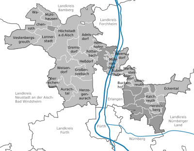

(Residents on December 31, 2019)
|
Other communities
|
Non- parish areas (102.72 km², uninhabited)
|
Stone crosses
There are numerous stone crosses in the district , most of which are also listed as architectural monuments .
Protected areas
There are six nature reserves , seven landscape protection areas , eight geotopes and eight designated FFH areas in the Erlangen-Höchstadt district . (As of March 2016)
See also:
- List of nature reserves in the Erlangen-Höchstadt district
- List of landscape protection areas in the district of Erlangen-Höchstadt
- List of FFH areas in the Erlangen-Höchstadt district
- List of geotopes in the Erlangen-Höchstadt district
License Plate
On August 5, 1974, the district was assigned the ER distinguishing mark , which had been valid for the Erlangen district since July 1, 1956 . On February 12, 1979, it was replaced by the ERH, which is still valid today . Since February 2, 2015, the license plate liberalization has also made the distinguishing mark HÖS ( Höchstadt an der Aisch ) available.
literature
- Franz Krug (ed.): The district of Erlangen-Höchstadt . Publishing house for authorities a. Economy, Hof (Saale) 1979, ISBN 3-921603-00-5 .
Web links
- Entry on the coat of arms of the district of Erlangen-Höchstadt in the database of the House of Bavarian History
- Federal Agency for Technical Relief Organization, Baiersdorf Local Association
- Literature from and about the district of Erlangen-Höchstadt in the catalog of the German National Library
- District Erlangen-Höchstadt: Official statistics of the LfStat
Individual evidence
- ↑ "Data 2" sheet, Statistical Report A1200C 202041 Population of the municipalities, districts and administrative districts 1st quarter 2020 (population based on the 2011 census) ( help ).
- ↑ Horst Auer: The navel of Franconia . In Nürnberger Nachrichten , June 5, 2008, last accessed on August 29, 2014
- ↑ Erlanger Nachrichten of February 13, 2020, p. 29
- ^ Wilhelm Volkert (ed.): Handbook of Bavarian offices, communities and courts 1799–1980 . CH Beck, Munich 1983, ISBN 3-406-09669-7 , p. 97 .
- ↑ The district in numbers. Retrieved April 20, 2020 .
- ↑ Entry on the coat of arms of the district of Erlangen-Höchstadt in the database of the House of Bavarian History , accessed on September 5, 2017 .
- ↑ Future Atlas 2016. (No longer available online.) Archived from the original on October 2, 2017 ; accessed on March 23, 2018 . Info: The archive link was inserted automatically and has not yet been checked. Please check the original and archive link according to the instructions and then remove this notice.
- ↑ PROGNOS future atlas. Handelsblatt, accessed on December 10, 2019 .
- ↑ 14 mayors hope for an east branch of the StUB. Erlanger Nachrichten, accessed on May 23, 2020 .
- ↑ "Data 2" sheet, Statistical Report A1200C 202041 Population of the municipalities, districts and administrative districts 1st quarter 2020 (population based on the 2011 census) ( help ).

Independent cities: Amberg | Ansbach | Bamberg | Bayreuth | Coburg | Erlangen | Fürth | Yard | Nuremberg | Schwabach | Willows in the Upper Palatinate
Districts: District of Amberg-Sulzbach | District of Ansbach | Bamberg district | Bayreuth district | District of Coburg | District of Erlangen-Höchstadt | Forchheim district | Fürth district | District of Haßberge | District of Kitzingen | District of Kronach | District of Kulmbach | District of Lichtenfels | District of Neumarkt idOPf. | District Neustadt adAisch-Bad Windsheim | District Neustadt ad Waldnaab | District of Nürnberger Land | District of Roth | District of Sonneberg | District of Tirschenreuth | Weißenburg-Gunzenhausen district | District of Wunsiedel in the Fichtel Mountains
Districts:
Aichach-Friedberg |
Altötting |
Amberg-Sulzbach |
Ansbach |
Aschaffenburg |
Augsburg |
Bad Kissingen |
Bad Toelz-Wolfratshausen |
Bamberg |
Bayreuth |
Berchtesgadener Land |
Cham |
Coburg |
Dachau |
Deggendorf |
Dillingen on the Danube |
Dingolfing-Landau |
Danube Ries |
Ebersberg |
Eichstätt |
Erding |
Erlangen-Höchstadt |
Forchheim |
Freising |
Freyung-Grafenau |
Fürstenfeldbruck |
Fürth |
Garmisch-Partenkirchen |
Gunzburg |
Hatred Mountains |
Yard |
Kelheim |
Kitzingen |
Kronach |
Kulmbach |
Landsberg am Lech |
Landshut |
Lichtenfels |
Lindau (Lake Constance) |
Main-Spessart |
Miesbach |
Miltenberg |
Mühldorf am Inn |
Munich |
Neuburg-Schrobenhausen |
Neumarkt in the Upper Palatinate |
Neustadt an der Aisch-Bad Windsheim |
Neustadt an der Waldnaab |
Neu-Ulm |
Nuremberg Country |
Oberallgäu |
Ostallgäu |
Passau |
Pfaffenhofen an der Ilm |
Rain |
Regensburg |
Rhön-Grabfeld |
Rosenheim |
Roth |
Rottal-Inn |
Schwandorf |
Schweinfurt |
Starnberg |
Straubing Arch |
Tirschenreuth |
Traunstein |
Unterallgäu |
Weilheim-Schongau |
Weißenburg-Gunzenhausen |
Wunsiedel in the Fichtel Mountains |
Wurzburg
Independent cities:
Amberg |
Ansbach |
Aschaffenburg |
Augsburg |
Bamberg |
Bayreuth |
Coburg |
Erlangen |
Fürth |
Hof (Saale) |
Ingolstadt |
Kaufbeuren |
Kempten (Allgäu) |
Landshut |
Memmingen |
Munich |
Nuremberg |
Passau |
Regensburg |
Rosenheim |
Schwabach |
Schweinfurt |
Straubing |
Willows in the Upper Palatinate |
Wurzburg