
Montoulieu (Hérault)
|
Montoulieu Montoliu |
||
|---|---|---|
.svg)
|
|
|
| region | Occitania | |
| Department | Herault | |
| Arrondissement | Lodève | |
| Canton | Lodève | |
| Community association | Cévennes Gangeoises et Suménoises | |
| Coordinates | 43 ° 56 ' N , 3 ° 47' E | |
| height | 159-522 m | |
| surface | 16.1 km 2 | |
| Residents | 161 (January 1, 2017) | |
| Population density | 10 inhabitants / km 2 | |
| Post Code | 34190 | |
| INSEE code | 34171 | |
| Website | http://www.montoulieu.fr/ | |
_mairie.JPG) Town hall (Mairie) of Montoulieu |
||

Montoulieu ( Occitan Montoliu ) is a place and a municipality in the south of France with 161 inhabitants (as of January 1, 2017) in the Hérault department in the Occitanie region . The municipality belongs to the arrondissement of Lodève and the canton of Lodève (until 2015: canton of Ganges ). The inhabitants are called the Montoulibans .
location
Montoulieu is located about 39 kilometers north-northwest of Montpellier in the southern foothills of the Cevennes . Montoulieu is surrounded by the neighboring communities of La Cadière-et-Cambo in the north, Saint-Hippolyte-du-Fort in the north-east, Pompignan in the east and south-east, Ferrières-les-Verreries in the south, and Saint-Bauzille-de-Putois in the west and south-west and Moulès-et-Baucels to the west and north-west.
Population development
| year | 1962 | 1968 | 1975 | 1982 | 1990 | 1999 | 2006 | 2017 | ||||
| Residents | 94 | 70 | 39 | 61 | 87 | 115 | 145 | 161 | ||||
| Sources: Cassini and INSEE | ||||||||||||
Attractions
- Saint-Etienne church
- Castle
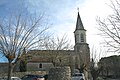
Saint-Etienne church

Castle
_eglise_Saint-%C3%89tienne_3.jpg)
_chateau.JPG)