
Villexavier
| Villexavier | ||
|---|---|---|
|
||
| region | Nouvelle-Aquitaine | |
| Department | Charente-Maritime | |
| Arrondissement | Jonzac | |
| Canton | Jonzac | |
| Community association | Haute-Saintonge | |
| Coordinates | 45 ° 22 ′ N , 0 ° 26 ′ W | |
| height | 48-90 m | |
| surface | 9.97 km 2 | |
| Residents | 272 (January 1, 2017) | |
| Population density | 27 inhabitants / km 2 | |
| Post Code | 17500 | |
| INSEE code | 17476 | |
 Town hall (Mairie) of Villexavier |
||

Villexavier is a French municipality with 272 inhabitants (as of January 1 2017) in the department of Charente-Maritime in the region Nouvelle-Aquitaine (before 2016 Poitou-Charentes ); it belongs to the arrondissement of Jonzac and the canton of Jonzac . The inhabitants are called Villexavierois .
geography
Villexavier is located about 72 kilometers north-northeast of Bordeaux . Villexavier is surrounded by the neighboring communities of Saint-Simon-de-Bordes in the north, Ozillac in the northeast, Fontaines-d'Ozillac in the east, Tugéras-Saint-Maurice in the south and southeast, Rouffignac in the south, Salignac-de-Mirambeau in the southwest as well Agudelle in the west.
Population development
| year | 1962 | 1968 | 1975 | 1982 | 1990 | 1999 | 2006 | 2017 |
| Residents | 282 | 274 | 262 | 277 | 269 | 247 | 299 | 272 |
| Sources: Cassini and INSEE | ||||||||
Attractions
- Saint-Christophe church, historic monument since 2003
- La Faye Castle, built in 1666, has been a monument historique since 2010
See also: List of Monuments historiques in Villexavier
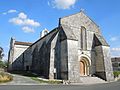
Saint-Christophe Church

La Faye Castle


literature
- Le Patrimoine des Communes de la Charente-Maritime. Flohic Editions, Volume 1, Paris 2002, ISBN 2-84234-129-5 , p. 333.