
Lorignac
| Lorignac | ||
|---|---|---|
|
||
| region | Nouvelle-Aquitaine | |
| Department | Charente-Maritime | |
| Arrondissement | Jonzac | |
| Canton | Pons | |
| Community association | Haute-Saintonge | |
| Coordinates | 45 ° 27 ′ N , 0 ° 41 ′ W | |
| height | 7-61 m | |
| surface | 17.53 km 2 | |
| Residents | 493 (January 1, 2017) | |
| Population density | 28 inhabitants / km 2 | |
| Post Code | 17240 | |
| INSEE code | 17210 | |
 Town hall (Mairie) of Lorignac |
||

Lorignac is a French municipality with 493 inhabitants (as of January 1 2017) in the department of Charente-Maritime in the region Nouvelle-Aquitaine (before 2016 Poitou-Charentes ); it belongs to the arrondissement of Jonzac and the canton of Pons (until 2015 Saint-Genis-de-Saintonge ). The inhabitants are called Lorignacais .
geography
Lorignac is located about 34 kilometers south-southwest of Saintes . Lorignac is surrounded by the neighboring communities of Saint-Fort-sur-Gironde in the north and west, Champagnolles in the north and northeast, Bois in the east and northeast, Saint-Ciers-du-Taillon in the south and southeast and Saint-Dizant-du-Gua in the South and southwest.
Population development
| year | 1962 | 1968 | 1975 | 1982 | 1990 | 1999 | 2006 | 2017 |
| Residents | 749 | 718 | 640 | 584 | 534 | 447 | 451 | 493 |
| Sources: Cassini and INSEE | ||||||||
Attractions
- Saint-Pierre church from the 12th century, monument historique since 1925
- Bardine Castle
See also: List of Monuments historiques in Lorignac
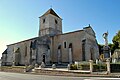
Saint-Pierre church

Bardine Castle


literature
- Le Patrimoine des Communes de la Charente-Maritime. Flohic Editions, Volume 2, Paris 2002, ISBN 2-84234-129-5 , pp. 826-827.