
Pommiers moulons
| Pommiers moulons | ||
|---|---|---|
|
||
| region | Nouvelle-Aquitaine | |
| Department | Charente-Maritime | |
| Arrondissement | Jonzac | |
| Canton | Les Trois Monts | |
| Community association | Haute-Saintonge | |
| Coordinates | 45 ° 20 ′ N , 0 ° 21 ′ W | |
| height | 49-114 m | |
| surface | 9.6 km 2 | |
| Residents | 207 (January 1, 2017) | |
| Population density | 22 inhabitants / km 2 | |
| Post Code | 17130 | |
| INSEE code | 17282 | |
 Pommiers-Moulons Town Hall |
||

Pommiers-Moulons is a southwestern French community with 207 inhabitants (as of January 1 2017) in the department of Charente-Maritime in the region Nouvelle-Aquitaine (before 2016 Poitou-Charentes ). The municipality belongs to the arrondissement Jonzac and the canton Les Trois Monts (until 2015 Montendre ). The inhabitants are called Pommier-Moulonnais .
location
Pommiers-Moulons is located in the south of the Saintonge about 60 kilometers north-northeast of Bordeaux . Pommiers-Moulons is surrounded by the neighboring communities of Chaunac and Vibrac in the north, Messac in the northeast, Mérignac in the east, Sousmoulins in the east and southeast, Montendre in the south and southwest and Expiremont in the west.
history
On January 1, 1974, Pommiers and Moulons were merged.
Population development
| year | 1962 | 1968 | 1975 | 1982 | 1990 | 1999 | 2006 | 2017 |
| Residents | 174 | 160 | 226 | 203 | 182 | 174 | 186 | 207 |
| Sources: Cassini and INSEE | ||||||||
Attractions
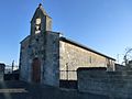
- Saint-Étienne church in Moulons, a historic monument since 1973
- Saint-Saturnin church in Pommiers
See also: List of Monuments historiques in Pommiers-Moulons

Saint-Etienne church
Saint-Saturnin Church


literature
- Le Patrimoine des Communes de la Charente-Maritime. Flohic Editions, Volume 1, Paris 2002, ISBN 2-84234-129-5 , pp. 503-504.