
Plassac (Charente-Maritime)
| Plassac | ||
|---|---|---|
|
||
| region | Nouvelle-Aquitaine | |
| Department | Charente-Maritime | |
| Arrondissement | Jonzac | |
| Canton | Pons | |
| Community association | Haute-Saintonge | |
| Coordinates | 45 ° 28 ′ N , 0 ° 34 ′ W | |
| height | 27-65 m | |
| surface | 15.48 km 2 | |
| Residents | 597 (January 1, 2017) | |
| Population density | 39 inhabitants / km 2 | |
| Post Code | 17240 | |
| INSEE code | 17279 | |
 Town hall (Mairie) of Plassac |
||

Plassac is a French municipality with 597 inhabitants (as of January 1 2017) in the department of Charente-Maritime in the region Nouvelle-Aquitaine ; it belongs to the arrondissement of Jonzac and the canton of Pons (until 2015: canton of Saint-Genis-de-Saintonge ). The inhabitants are called Plassacais .
geography
Plassac is located about 31 kilometers south-southeast of Saintes . Plassac is surrounded by the neighboring communities of Saint-Genis-de-Saintonge in the north, Saint-Sigismond-de-Clermont in the east, Consac in the south, Saint-Ciers-du-Taillon in the west and south-west and Bois in the west and north-west.
The village is on the Via Turonensis , a variant of the Way of St. James .
Population development
| year | 1962 | 1968 | 1975 | 1982 | 1990 | 1999 | 2006 | 2013 |
| Residents | 435 | 384 | 368 | 339 | 387 | 388 | 547 | 614 |
| Source: Cassini and INSEE | ||||||||
Attractions
See also: List of Monuments historiques in Plassac (Charente-Maritime)
- Saint-Laurent Church, Monument historique
- Plassac Castle, Monument historique
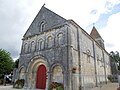
Saint Laurent Church
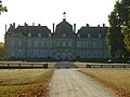
lock


literature
- Le Patrimoine des Communes de la Charente-Maritime. Flohic Editions, Volume 2, Paris 2002, ISBN 2-84234-129-5 , pp. 829-830.