
Salignac-sur-Charente
| Salignac-sur-Charente | ||
|---|---|---|
|
||
| region | Nouvelle-Aquitaine | |
| Department | Charente-Maritime | |
| Arrondissement | Jonzac | |
| Canton | Thénac | |
| Community association | Haute-Saintonge | |
| Coordinates | 45 ° 40 ′ N , 0 ° 25 ′ W | |
| height | 2–22 m | |
| surface | 10.22 km 2 | |
| Residents | 599 (January 1, 2017) | |
| Population density | 59 inhabitants / km 2 | |
| Post Code | 17800 | |
| INSEE code | 17418 | |

Salignac-sur-Charente is a French municipality with 599 inhabitants (at January 1, 2017) in the department of Charente-Maritime in the region Nouvelle-Aquitaine . It was created in 1876 when Pérignac broke away . Until 1952 it was called Salignac-de-Pons . The residents call themselves Salignacais .
geography
The municipality of Salignac-sur-Charente is located on the border with the Charente department , at the confluence of the canalized river Né ( Canal du Né ) in the Charente .
The districts of Le Prunelas, Le Pérat and Monseuille belong to the municipality of Salignac .
The neighboring municipalities are Chérac in the north, Saint-Laurent-de-Cognac in the northeast, Merpins in the east, Ars in the southeast, Pérignac in the south and Brives-sur-Charente in the west.
Population development
| year | 1962 | 1968 | 1975 | 1982 | 1990 | 1999 | 2007 | 2017 |
|---|---|---|---|---|---|---|---|---|
| Residents | 522 | 542 | 494 | 485 | 504 | 545 | 626 | 599 |

Mairie Salignac
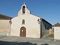
Saint-Pierre et Saint-Sulpice church


Attractions
See: List of Monuments historiques in Salignac-sur-Charente