
Colle di Tenda
| Colle di Tenda | |||
|---|---|---|---|
 Pass of the Colle di Tenda |
|||
| Compass direction | North | south | |
| Pass height | 1871 m | ||
| region | Cuneo Province , Piedmont | Department Alpes-Maritimes | |
| Watershed | Roya | ||
| Valley locations | Vernante | Breil-sur-Roya , Ventimiglia | |
| expansion | Pass road (partly gravel) / road tunnel / railway tunnel | ||
| Mountains | Maritime Alps / Ligurian Alps | ||
| profile | |||
| Denzel scale | SG 2-3 | SG 3-4 | |
| Ø pitch | 5.4% (1071 m / 19.8 km) | 3.1% (1871 m / 61 km) | |
| Max. Incline | 9% (on km 12) | ||
| map | |||
|
|||
| Coordinates | 44 ° 8 '59 " N , 7 ° 33' 42" E | ||

The Colle di Tenda (German Tenda Pass , French Col de Tende ) is a crossing over the Alps between Italy and France . It separates the Maritime Alps from the Ligurian Alps . The pass road of the same name, which was developed under Napoleon , connects the Turin area with Nice via the cities of Cuneo in Piedmont and Ventimiglia on the Mediterranean . The pass itself is considered to be the southernmost of the great Alpine passes. The top of the pass at 1871 m is located directly on the border between France and Italy .
Above the tunnel entrance, the north ramp with its twelve bends is rather inconspicuous, while the south ramp, with its 46 bends, some of which are close together, is one of the most spectacular pass roads in the Alps. It is only partly asphalted and closed to traffic.
From the top of the Tendapass, head east over the Colle di Perla ( 2086 m ) to the Ligurian border ridge road, which then meanders south, past Monte Saccarello ( 2200 m ), towards Ventimiglia along the ridge. At the top of the Tendapass heading west, the slope to the Baisse de Peyrefique branches off.
Tenda road tunnel
Since the completion of the 3,182 meter long Col-de-Tende road tunnel in 1882 as the first and longest road tunnel under an Alpine pass until the opening of the tunnel under the Great St. Bernard Pass , the winding road over the top of the pass has only become Used in summer.
Tenda rail tunnel
Parallel to the road tunnel, the Colle di Tenda is also crossed by a rail tunnel. This 8,099 m long structure was built in 1898 and is part of the Tendabahn , one of the most spectacular railway lines in Europe . At the time of opening, it was the fourth longest tunnel in the world.
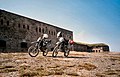
Fortresses on the top of the pass and in the surrounding area
At the top of the pass of the Colle di Tenda there are extensive fortresses from the 19th century, which were built by Italians. They became useless after World War II when the 1947 peace treaty between Italy and France moved the border behind the fortresses.
The names of the fortresses:
- Forte Centrale at 1908 m directly at the top of the pass
- Fort de la Marguerie at 1842 m
- Fort Tabourde at 1982 m
- Fort Pernante at 2117 m
- Fort de Giaure at 2253 m
- Fort Pepin at 2263 m
tourism
Long-distance / long-distance hiking trails
The French long-distance hiking trail GR 52A , the Sentier Panoramique du Mercantour , begins at the Col de Tende, right on the border . The red path of the Via Alpina and the Grande Traversata delle Alpi also run over the pass .

Serpentine sequence on the south ramp in France, in the background the exit from the road tunnel
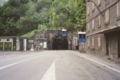
Portal of the Tenda road tunnel on the Italian side
Fort Central (north side)


literature
- Sabine Bade, Wolfram Mikuteit: Piedmont hiking . Michael-Müller-Verlag, Erlangen 2010, ISBN 978-3-89953-566-2 .
- Sabine Bade, Wolfram Mikuteit, Grande Randonnée 52A. Le Sentier panoramique du Mercantour . Fernwege Verlag, 3rd edition 2010, ISBN 978-3-937304-78-6 .
- Charles Botton, Michel Braun: Le Col de Tende - Il Colle di Tenda - The Tendapass . Les Editions du Cabri, Breil-sur-Roya 1991.
Web links
- Olivier Koot: Aux Photos de la Roya: Col de Tende, 1,871 m. In: tiscali.be/olivier.koot. Archived from the original on September 10, 2004 (French, pictures of the pass and the fortifications).
- Colle de Tenda, da Vernante - Lime. Archived from the original on July 8, 2009 (gradient profile of the pass road on the Italian side).
- Colle de Tenda, da Breil. Archived from the original on July 8, 2009 (gradient profile of the pass road on the French side up to the portal of the Tenda road tunnel).
- Michael Panitzki: Col de Tende / Colle di Tenda. In: arcor.de/m.panitzki. Archived from the original on January 23, 2007 .
Agnel • Allos • Andrion • Aravis • Bonette • Braus • Cayolle • Champs • Colle-Saint-Michel • Colombière • Croix de Fer • Croix-Fry • Cuillole • Galibier • Gets • Glandon • Granon • Iseran • Izoard • Jambaz • Joux Plane • Joux Verte • Larche • Lautaret • Lebraut • Lombarde • Madeleine • Saint Martin • Méraillet • Mollard • Mont Cenis • Montets • Montgenèvre • Morgins • Moutière • Ornon • Pré • Petit Saint-Bernard • Pontis • Ramaz • Roselend • Rousset • Saisies • Télégraphe • Tende • Turini • Valberg • Vars
Agnello • Aprica • Assietta • Aurine • Borcola • Bordala • Brennero / Brenner • Brocon • Cadibona • Campo Carlo Magno • Campolongo • Camporosso (Saifnitzer) • Carnizza • Castrin / Hofmahd • Cereda • Ciampigotto • Cibiana • Cimabanche • Coe • Colombardo • Croce d'Aune • Croce Domini • Crocette • Costalunga / Karer • Duran • Eira • Eores / Kofel • Esischie • Erbe / Würz • Falzarego • Fauniera • Fedaia • Finero • Finestre • Foppa • Foscagno • Furcia / Furkel • Fusine (Ratschacher ) • Gavia • Gardena / Grödner • Giau • Gola / Klamml • Gran San Bernardo • Kreit • Lavazè • Livigno • Lombarda • Lúsia • Lys • Maddalena • Manghen • Mauria • Mendola / Mendel • Mont Rest • Monte Croce / Plöcken • Monte Croce di Comélico / Kreuzberg • Monte Giovo / Jaufen • Mortirolo • Nevea • Nigra / Niger • Palade / Gampen • Pampeago / Pale / Reiter • Pénnes / Penser • Pian delle Fugazze • Piccolo San Bernardo • Pordoi • Pramollo (Nassfeld) • Predil • Resia / Reschen • Rolle • Russis • Rombo / Timmel • Sampeyre • San Antonio • San Boldo • San Giovanni • San Lugano • San Marco • San Pellegrino • Santa Maria (Umbrail) • Sella • Sestriere • Sommo • Spluga (Splügen) • Stalle / Staller • Staulanza • Stelvio / Stilfser • Tanamea • Tenda • Tonale • Tre Croci • Tremalzo • Valles • Valcavera • Valparola • Vezzena • Vivione • Zovo