
Rheinbach
| coat of arms | Germany map | |
|---|---|---|

|
Coordinates: 50 ° 38 ' N , 6 ° 57' E |
|
| Basic data | ||
| State : | North Rhine-Westphalia | |
| Administrative region : | Cologne | |
| Circle : | Rhein-Sieg district | |
| Height : | 173 m above sea level NHN | |
| Area : | 69.72 km 2 | |
| Residents: | 26,986 (Dec. 31, 2019) | |
| Population density : | 387 inhabitants per km 2 | |
| Postal code : | 53359 | |
| Primaries : | 02226, 02225, 02255 | |
| License plate : | SU | |
| Community key : | 05 3 82 048 | |
| LOCODE : | DE RHH | |
| City structure: | 9 districts | |
City administration address : |
Schweigelstrasse 23 53359 Rheinbach |
|
| Website : | ||
| Mayor : | Stefan Raetz ( CDU ) | |
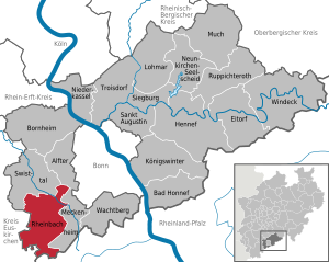
| Location of the city of Rheinbach in the Rhein-Sieg district | ||
  |
||

Rheinbach is a town in the Rhein-Sieg district in North Rhine-Westphalia and has the special status of " Middle district town ". Rheinbach is 16 kilometers southwest of Bonn city center .
geography
Geographical location
Rheinbach is located on the left bank of the Rhine, 16 km southwest of downtown Bonn and 34 km south of Cologne . The city itself is located in the Voreifel , for the most part still on the level of the Lower Rhine Bay , but the urban area also includes some villages in the Ahr Mountains that adjoin to the south.
Rheinbach's highest point is the surveying point ( ⊙ ) 406.5 m above sea level near Todenfeld . NHN , which offers a very good view of the Eifel and towards the foothills and Ville . From the ruins of Tomburg above Wormersdorf you have a view far into the Cologne Bay. When the weather is clear, you can see the Cologne Cathedral from the Tomburg and vice versa from the tower of the cathedral the Tomburg.
City structure


In addition to the core city with around 17,000 inhabitants, the "localities" and "residential areas" form the districts of Rheinbach.
| Localities | ||
|---|---|---|
The villages to the south and southwest of Rheinbach on the Eifel heights are collectively referred to as high places .
| Living spaces | ||
|---|---|---|
|
to Neukirchen
|
to Queckenberg
|
to Ramershoven
to Wormersdorf
|
| Swisttal | Alfter | |
| Euskirchen |
.svg)
|
Meckenheim |
| Bad Münstereifel |
Altenahr (Rhineland-Palatinate) |
history


The name Rheinbach originated from Reginbach. The first part of the name is probably derived from the Old High German word "regan" = rain, so that the later place name was probably first used to refer to a stream that only had enough water when it was raining.
Ancient to Middle Ages
The Roman aqueduct from the Eifel to Cologne , also called the Roman Canal and built around 80 AD, led through what is now Rheinbach's urban area. Some recovered parts are set up in the city, such as B. on the Pützstrasse a section that comes from Mechernich- Breitenbenden , and at the roundabout Aachener Strasse a section that was recovered in Rheinbach and whose bottom and cheeks are made of Roman stamped concrete. The aqueduct ran under what is now Münstereifeler Strasse and Bahnhofstrasse in Rheinbach. After the Roman period, the Eifel aqueduct in Rheinbach was exploited for the extraction of building material. So one finds z. B. At the Wasemer Tower and the Hexenturm in Rheinbach existing building material made of Roman stamped concrete was built.
The first mention of the settlement as Reginbach took place on 13 August 762 when the Frankish king Pippin and his wife Bertrada the Prüm Abbey donated lands in the vicinity of the present city Rheinbach. When the Prüm Abbey was attacked by marauding Vikings in 892 , robbed and all documents set on fire, the abbot had a list of the abbey's goods drawn up the following year. This Prümer Urbar lists almost fifty farm positions owned by the abbey for Rheinbach ( called Rembahc there), thus identifying them as the largest landlord in the region.
In the 12th century, a nobleman named Emelricus is mentioned as Lord von Rheinbach. The family of the Knights of Rheinbach, who were initially “employees” of Prüms, lived in the Rheinbach Castle and became more and more powerful in the period that followed. In 1246, Count Friedrich von Hochstaden , who was then Prümer Vogt a. a. was in Rheinbach, the bailiwick rights to his brother Konrad , Archbishop of Cologne. After confirmation by the Prüm Abbot, the Archbishop of Cologne was now the sovereign in Rheinbach. But when the Archbishopric suffered a heavy defeat in the Battle of Worringen in 1288 and was thereby greatly weakened, the Lords of Rheinbach took over. They fortified the place with walls, towers and half-towers. The knights of Rheinbach built a city illegally without the permission of the sovereign. In 1298 the place was first referred to as "oppidum". In 1343, when the Rheinbach dynasty was expected to die out, the Cologne bishop regained all rights to the castle and city of Rheinbach and the city remained part of the Archbishopric of Cologne until 1789 and was thus under the control of Kurkölner .
In the period that followed, Rheinbach also developed into the administrative center for the revenue from the Electorate of Cologne from the county of Neuenahr . After Neuenahr's loss to Jülich , Rheinbach's importance for the archbishop sank enormously and he often pledged the city to larger or smaller lords. Thus further expansion of the city was inhibited. The initially flourishing cloth trade and the regionally important tanning industry increasingly lost their importance.
Early modern age
The witch trials in Rheinbach, which raged between 1631 and 1636, are reminiscent of the witch's tower , which then served as a prison and is part of the Rheinbacher Burg, which was built by the lords of Rheinbach towards the end of the 12th century and which still exists today in parts . Under the witch commissioners Franz Buirmann and Jan Möden, around 130 people from Rheinbach, Flerzheim and Meckenheim were accused of being witches, tortured and burned. In Rheinbach, the witch hunts turned out to be a murderous power struggle within the urban ruling class. Five of the seven lay judges had to flee or were murdered. Hermann Löher , the former mayor, escaped to Amsterdam and later published a detailed chronicle of these events there under the title Urgent Subjects Wemütige Klage der Pious Invalid . The witch judges burned Vogt Schwegeler in front of the city gates.
On June 11, 2012, the Rheinbach City Council unanimously distanced itself from the atrocities that occurred in the 16th and 17th centuries in the Rheinbach city area and regretted that innocent women and men were denounced, tortured, killed by torture or finally executed as witches and wizards have been; Torture and the death penalty were wrong then as now.
In 1673 the Prince of Orange stood before the city with four regiments. After Mayor Averdunck refused to surrender Rheinbach voluntarily, the prince's troops plundered the city and set it on fire. Only 20 of the 150 houses were spared from the fire. 25 Rheinbach citizens and 23 farmers from the surrounding towns perished.
French Revolution to World War II
After French troops marched into the Rhineland in 1794, Rheinbach became part of a newly formed Département de Rhin-et-Moselle . From 1802, when the German areas west of the Rhine were integrated into the French state, the Rheinbachers were also French citizens. As a result of this incorporation into the French state, the previous proclamation of the republic “Free Land Rheinbach” by the journalist Johann Baptist Geich remained only a footnote in history. Geich and his colleagues had intended to establish an independent Rhenish Republic based on the French model. During this time, the villages that still belong to Rheinbach today were administratively connected to the city center.
After the successful wars of liberation - but especially as a result of the Congress of Vienna - Rheinbach fell to Prussia in 1815 and first became part of the Grand Duchy of the Lower Rhine and then, until 1945, part of the Rhine Province . At the Potsdam Conference this was divided into a French and a British sector. Rheinbach was right on the sector border, but still in the British area. The sector border at that time is identical to the border with the district of Ahrweiler, which lies in the state of Rhineland-Palatinate , and is therefore also the state border.
In 1820 the demolition of the Rheinbach city fortifications began. At the beginning of the 1850s, the mining and smelting of iron ore began in Rheinbach. But after a few years this mining was stopped. The copper and lead ore mining, which had been in operation for centuries in the high places in Rheinbach - most recently at the Hedwigsglück mine - ended with the First World War.
As a Prussian district capital, later a district town, Rheinbach developed into an important location for the authorities. The local civil service attached great importance to a good school education for their children, so that in 1852 a higher municipal educational institution was established, which in 1909 was recognized as a full high school. In 1862 Rheinbach was allowed to call itself “city” again after it had lost these rights in the French times as a result of the equality of town and country.
In 1866 a branch of the poor servants of Jesus Christ was opened in Rheinbach . The sisters devoted themselves to nursing and set up a children's repository and a handicraft school for girls. From 1869 the Rheinbacher Hospital developed from this, but closed its doors in 2006 and has now been converted into a nursing ward with the adjacent Marienheim senior citizens' home.
The connection to the railroad network in 1880 enabled the development of an important ceramics industry that reached its artistic peak around 1960. Two factories still work here today.
In 1914 the penal institution, now the Rheinbach correctional facility , was founded in Rheinbach . For a few decades there was a department for long-term prisoners, which helped the prison to become known beyond the borders of Rheinbach due to some spectacular outbreaks, but also due to prominent inmates such as the "Chancellor's spy" Günter Guillaume . From 1918 to 1929 the city was occupied first by the British, then by the French.
The city was badly affected during the Second World War . In 1901 113 Jews lived here, who also had a synagogue, their own cemetery and their own school. In 1942 the last Jewish citizens of Rheinbach were deported to Eastern Europe. 34 of them were murdered there. Many buildings, including the parish church, were completely destroyed by aerial bombing. Rheinbach and the Rheinbach-Land office had almost 700 war deaths in this war. Half of them fell as soldiers at the front, the other half through artillery fire or bombing at home. Rheinbach as well as the city of Meckenheim were on the advance route of the 9th US Armored Division on the way to the famous Ludendorff Bridge (" Bridge of Remagen ").
present
Glass refiners expelled from the Sudetenland settled in Rheinbach after the Second World War. By September 1947, eight specialist glass companies from Bohemia had settled in the city, which established Rheinbach's reputation as a “glass city”. As early as 1948, a state glass technical school was opened in Rheinbach, which today operates under the name “State Vocational College for Glass, Ceramics, Design of the State of North Rhine-Westphalia” and has gained international recognition.
As part of the Bonn-Berlin Compensation, a department of the Bonn-Rhein-Sieg University of Applied Sciences was set up in Rheinbach in 1995. In 1968 the Friends of Noble Glass Association opened the Rheinbach Glass Museum with the focus on “Bohemian Hollow Glass”, which has been established in the Himmeroder Hof since 1989.
On August 1, 1969, the city of Rheinbach and the previously independent municipalities of Flerzheim, Hilberath, Neukirchen, Niederdrees, Oberdrees, Queckenberg, Ramershoven, Todenfeld and Wormersdorf, which were previously independent and belonging to the Rheinbach-Land office, were merged to form the new city of Rheinbach.
Rheinbach as a Bundeswehr location
From 1935 and then throughout the war, personnel from the Reich Labor Service and later soldiers were stationed in Rheinbach. The history of Rheinbach as a garrison town began in 1951 with the establishment of a camp for the stationing of Allied troops. This decision to deploy was very controversial among the Rheinbachers. In 1952, the Belgian 31st anti-aircraft battalion moved into the recently completed barracks in Rheinbach. Four years later, the Belgian troops withdrew from Rheinbach again, so that in 1957, with the establishment of the Guard Battalion BMVg, Rheinbach became the Bundeswehr base .
This year, a command telecommunications company was housed in the Bundeswehr camp on Münstereifeler Strasse, which quickly grew up to be a battalion and telecommunications regiment, the highest command of the Bundeswehr, and ultimately the 900 Command Support Brigade. The telecommunications association was downsized, restructured and relocated several times after the German government moved to Berlin.
Rheinbach was also the stationing site for the Telecommunication Command 900 , which was stationed at Stadtpark 14 ( ⊙ ), today the Albert Schweitzer School . It was the forerunner of the Strategic Reconnaissance Command , which entered service on January 17, 2002 in the Tomburg barracks . The command moved the main forces to Grafschaft-Gelsdorf in 2007/2008 .
In May 1968, the name board Tomburg Barracks ( ⊙ ), named after the district Wormersdorf located Tomburg revealed.
Today the Tomburg barracks house:
- Operations center IT system of the Bundeswehr (BtrbZ IT-SysBw, BITS)
- Cyber Operations Center (ZCO) as well
- Parts ZCSBw, KdoITBw, EMilPfa, BwDLZ and
- BWI GmbH
Population development
| year | Residents | delta | source |
|---|---|---|---|
| 1867 | 1,867 | ||
| 1872 | 1,889 | + 22 | |
| 1971 | 20,000 | +18,111 | |
| 1995 | 24,963 | +4,963 |
- annotation
- Residents from 1995 with main and secondary residence as of December 31, including the localities of the city of Rheinbach.
|
|
|
|
|
- annotation
- Residents from 2015 according to the written information from the City of Rheinbach, Citizens' Office (email: Bü[email protected]) dated May 6, 2019.
religion
Catholic parishes

- Catholic parish St. Martin, Rheinbach in the deanery Meckenheim-Rheinbach ( Archdiocese of Cologne ) with the churches
- St. Martin in Flerzheim
- St. Martin in Hilberath
-
St. Margareta in Neukirchen
- St. Mary's Assumption in Merzbach
- St. Antonius in Niederdrees
- St. Aegidius in Oberdrees
- St. Joseph in Queckenberg
- St. Basilides in Ramershoven
- St. Hubertus in Todenfeld
- St. Bartholomew in Kalenborn
- St. Martin in the core town of Rheinbach (parish church)
- Catholic parish of St. Martin , Wormersdorf in the Meckenheim parish community (Meckenheim-Rheinbach dean's office).
Monasteries and branches of religious communities in Rheinbach
- Deutscher Orden (OT): monastery and parish pastoral care (September 1, 2012 to November 15, 2014)
- Pallottines (SAC): monastery and school (until July 2016)
- Sisters of Our Lady (SND) : monastery, school and boarding school (1911–1999)
- Daughters of Divine Love (DDL): Antoniuskloster in Flerzheim (with the seat of the German Region of the Order; approx. 1990–2015)
- Poor Maidservants of Jesus Christ (ADJC): Hospital (October 23, 1866 to October 1, 1965); Hermanianum (April 15, 1890 to April 15, 1935).
Evangelical congregations
- Ev. Rheinbach parish, Gnadenkirche
- Free Ev. Community, FEG
politics
City council
From 22,058 citizens entitled to vote, 12,677 valid votes were cast on May 25, 2014. The following shows the distribution of votes and the number of mandates for the parties from a total of 36 council seats:
| Political party | percent | Seats |
|---|---|---|
| CDU | 45.46 | 17th |
| SPD | 28.26 | 10 |
| UWG | 9.46 | 3 |
| FDP | 7.99 | 3 |
| Green | 8.69 | 3 |
coat of arms
 |
Blazon : “In the divided field, above in silver a continuous black cross, below split, on the left ( heraldic right ) in silver a blue key turned left with the beard, on the right (heraldic left) on a red background a blue armored half silver eagle at the gap . " |
| Justification of the coat of arms: The black cross on a silver background stands for the Archbishopric of Cologne. The key points to St. Peter as patron of the church or the archbishopric. The eagle from the coat of arms of the Counts of Are-Hochstaden ties in with the transfer of 1246/47 and ignores the illegal appropriation of the property by the Knights of Rheinbach. The city coat of arms goes back to the second jury seal, which has existed with an imprint since 1344. The coat of arms was awarded in 1915 by King Wilhelm II of Prussia and was confirmed in 1970 by the regional president of North Rhine-Westphalia. The city's flag color is black and white. |
Town twinning
- Deinze , Belgium
- Kamenický Šenov (Steinschönau) , Czech Republic
- Sevenoaks , Kent, United Kingdom
- Villeneuve-lès-Avignon , France
Culture and sights, leisure
Museums
- Rheinbach Glass Museum
- Mostert Carriage Museum
- Nature Park Center of the Rhineland Nature Park in Himmeroder Hof
Buildings

- Parish Church of St. Martin Rheinbach
- Tomburg castle ruins near Wormersdorf
- Witch tower
- Wasemer tower
- Kallenturm
- Windmill tower
- Bocksturm
- Himmeroder Hof (Rheinbach)
- Waldhotel Rheinbach
- Forest chapel
- Roman aqueduct ("Roman Canal")
- "Altes Bürgerhaus" (not preserved, floor plan in the pavement of the little square "Am Bürgerhaus" - Hauptstrasse / corner of Bachstrasse - based on)
- Haus Am Bürgerhaus 5 (Raths), one of the older buildings in Rheinbach with cellar parts from the 16th century, formerly a tannery, leather trade, sawmill / timber trade, wheelwright, restaurant
- former “Herberge zum Heiligen Geist”, Martinstrasse 12
- The Hans Wischeler Tower was a 16 m high wooden observation tower on the 291.9 m above sea level southwest of Rheinbach . NHN high Beuelskopf, which was destroyed by arson in 2002. Reconstruction plans have existed for several years.
- Former water tower from the 1890s, until 2019 the studio of the late studio glass artist Udo Edelmann .
leisure
- In addition to the amusement park with a children's playground, lakes, mini golf course and barbecue areas, the monte mare leisure pool and sauna paradise with its 10 meter deep indoor plunge pool is one of the popular destinations.
- Always on the third weekend in July, the Rheinbach Classics take place in Rheinbach , a supraregional classic car festival that annually attracts over 30,000 spectators from all over Germany and neighboring countries.
Infrastructure and economy
traffic
Rail transport

The Rheinbach station is on the Voreifelbahn (Bonn Hbf – Rheinbach – Euskirchen (–Bad Münstereifel)), on which the S-Bahn line 23 runs for local rail passenger transport (SPNV) .
Local rail passenger transport is carried out by the DB Regio NRW , which uses DB class 644 diesel multiple units for the Voreifelbahn in single to double traction for speeds of up to 100 km / h.
Bus transport
Regionalverkehr Köln GmbH (RVK) bus routes connect Rheinbach in a star shape with Bonn via Witterschlick , Euskirchen , various localities in the Swisttal community and also with Meckenheim . Within Rhine brook runs under the name "Rheinbacher city hop" a district bus with a barrier-free minibus (route number 813). The tariff of the Verkehrsverbund Rhein-Sieg (VRS) applies to all these lines .
Further lines from the VRM (Verkehrsverbund Rhein-Mosel) connect Rheinbach and its high places with several districts of Altenahr as well as with Ersdorf and Altendorf .
Streets
Rheinbach is on the federal highway 61 Cologne - Ludwigshafen am Rhein . The central area of Rheinbach and several districts are also accessed from federal highway 266 .
On January 1, 2018, 19,550 motor vehicles were registered in Rheinbach, 16,594 of which were cars.
Bike paths
The city is connected to several cycle routes:
- The 524 km long moated castle route connects more than 130 castles on the edge of the Eifel and in the Cologne Bay .
- The 1,045 km long D-Route 4 ( Mittelland Route ) leads from Aachen via Bonn , Siegen , Erfurt , Jena and Chemnitz to Zittau .
- The 733 km long D-Route 7 ( pilgrim route ) leads from Aachen via Cologne , Düsseldorf , Duisburg , Münster , Osnabrück , Bremen and Hamburg to Flensburg .
education
There are five primary schools, one comprehensive school and two grammar schools in the city.
The Rheinbach Municipal Gymnasium is the oldest school in Rheinbach, the Archbishop's St. Joseph Gymnasium (previously for girls, now bi-educational ) is a private gymnasium; it took over the students of the Vinzenz-Pallotti-Kolleg (for boys), which was closed in July 2016. The community secondary school Am Dederichsgraben and the Tomburg secondary school are being dissolved in favor of a comprehensive school. The Albert Schweitzer School, a special needs school with a special focus on learning, was closed in July 2016 due to insufficient numbers of registrations.
In addition, Rheinbach is home to the State Vocational College for Glass, Ceramics, Design for the State of North Rhine-Westphalia and the Bonn-Rhein-Sieg University of Applied Sciences , which has a second location in Sankt Augustin on the right bank of the Rhine .
Industry
The Heinrich Frings GmbH & Co. KG is the global market leader in automated systems for vinegar production.
Telephone prefixes
The city has the area code 02226. Deviating from this, the 02225 in Flerzheim and Wormersdorf and the 02255 in Queckenberg, Loch and Hardt-Sürst apply.
Personalities
sons and daughters of the town
- Johannes Adam von Nettinghofen (1680–1738), Rector of the University of Vienna, Bohemian Knight and Lower Austrian Regimental Councilor
- Johann Joseph Müller (1768–1850), canon in Cologne and benefactor of his hometown Rheinbach
- Andreas Gau (1800–1862), Catholic theologian, lecturer and subregional in Cologne, canon in Aachen, member of the Prussian state parliament for the constituency of Bonn-Rheinbach
- Andreas Simons (1823–1900), architect
- Emil Meyer (1869–1949), evangelist of the Pietist movement, writer and publisher
- Anton Schrammen (1869–1953), paleontologist and dentist, expert on fossil sponges and cephalopods
- Jakob Schrammen (1871–1944), architect and construction officer
- Elke Erb (* 1938, Scherbach), writer
- Ute Erb (* 1940, Scherbach), poet
- Frank Kolb (* 1945, Merzbach), ancient historian (professor at the Eberhard Karls University of Tübingen)
- Bernd Schumacher (* 1952), crime novelist and songwriter
- Heike Kaster-Meurer (* 1964), local politician (SPD)
- Barbara Ruscher (* 1969), cabaret artist
- Tim Lobinger (* 1972), track and field athlete and Olympic participant
- Stefan Parinussa (* 1974), racing cyclist
- Antoine Monot, Jr. (born 1975), actor
- Markus Pröll (* 1979), soccer player
- Jérôme Becher (* 1979), European record holder in 24-hour swimming
- Judith Stapf (* 1997), violinist
Other personalities associated with the city
- Andreas Schweigel (1566–1636), lawyer, electoral bailiff and opponent of witch trials
- Franz Buirmann (1590 – after 1638), electoral Cologne witch commissioner
- Hermann Löher (1595–1678), opponent of the witch trials
- Wilhelm Busch (1867–1923), member of the Preuss. House of Representatives (center), Parliamentary State Secretary in the Prussian Ministry of Agriculture, honorary citizen of Rheinbach in 1922
- Peter Jakob Schrammen (1838–1903), high school teacher and rector in Rheinbach, holder of the Red Eagle Order, 4th class
- Hans Hirschmann (1893–1968), doctor and mayor of Rheinbach, district administrator of the Bonn district
- Joseph Roth (1896–1945), teacher, politician and Nazi opponent, since 2000 martyr of the Cath. church
- Hans von der Groeben (1907–2005), diplomat, scientist and publicist
- Franz Wendler (1913–2007), glass artist
- Paul Reding (* 1939), artist and writer
- Wolfgang Niedecken (* 1951), singer, musician and visual artist
- Stefan Raetz (* 1959), mayor
- Thomas Quast (* 1962), judge, musician and composer
- Norbert Röttgen (* 1965 in Meckenheim), politician (CDU), 2009–2012 Federal Environment Minister
- Jenny Elvers (* 1972), actress and presenter
- Hans Adu Sarpei (* 1976), Ghanaian soccer player
- Alexander Hennig (* 1977), German economist
- Artur Kolodziejski (* 1979), German basketball player
- Christian Knees (* 1981), professional cyclist
- Lukas Sinkiewicz (* 1985), national soccer player (Germany) of Polish origin
- Pius Heinz (* 1989), world poker champion
literature
- Carl-Wilhelm Clasen: City of Rheinbach (= Rheinischer Verein für Denkmalpflege und Landschaftsschutz [Hrsg.]: Rheinische Kunststätten . Issue 249). 2nd Edition. Neusser Druckerei und Verlag, Cologne 1988, ISBN 3-88094-623-X .
- Klaus Fink: History of the castle, the city and the Rheinbach office: from the beginning to the end of the 18th century. Roehrscheid Verlag, Bonn 1965.
- Klaus Fink: Rheinbach under the crook. City of Rheinbach, Rheinbach 2005, ISBN 978-3-9806176-1-1 .
- Klaus Grewe : On Roman traces around Rheinbach. Water pipes and trunk roads from Roman times to the Middle Ages (= Rheinischer Verein für Denkmalpflege und Landschaftsschutz (Ed.): Rheinische Kunststätten. Issue 466). 1st edition. Neusser Druckerei und Verlag GmbH, Neuss 2001, ISBN 3-88094-884-4 .
Web links
|
Further content in the sister projects of Wikipedia:
|
||
|
|
Commons | - multimedia content |
|
|
Wiktionary | - Dictionary entries |
|
|
Wikisource | - Sources and full texts |
|
|
Wikivoyage | - Travel Guide |
Individual evidence
- ↑ Population of the municipalities of North Rhine-Westphalia on December 31, 2019 - update of the population based on the census of May 9, 2011. State Office for Information and Technology North Rhine-Westphalia (IT.NRW), accessed on June 17, 2020 . ( Help on this )
- ^ Klaus Grewe: Aqueducts. Water for Rome's cities. The big overview - from the Roman Canal to the aqueduct marble. Regionalia Verlag, Rheinbach 2014, ISBN 978-3-95540-127-6 , p. 295.
- ^ Regesta Imperii RI I n. 95 of August 13, 762 [1] (online); accessed on July 30, 2017.
- ^ Heinrich Beyer: Document book for the history of the Middle Rhine territories, now the Prussian administrative districts of Coblenz and Trier. Edited from the sources by Heinrich Beyer. First volume: From the oldest times up to the year 1169. Hölscher, Coblenz 1860, p. 20 .
- ^ Heinrich Beyer: Document book for the history of the Middle Rhine territories, now the Prussian administrative districts of Coblenz and Trier. Edited from the sources by Heinrich Beyer. First volume: From the oldest times to the year 1169. Hölscher, Coblenz 1860, p. 189 .
- ^ Hunting witches in Rheinbach, accessed October 2, 2012.
- ↑ List of the known victims of the witch trials from Rheinbach and the glory of Flerzheim. (PDF) www.anton-praetorius.de, 2012, accessed on April 5, 2017 .
- ^ City of Rheinbach distances itself from the pursuit of witches. In: General-Anzeiger Bonn of June 13, 2012.
- ^ Mario Quadt: Gold rush mood in the glass city. In: General-Anzeiger (Bonn). April 11, 2016, accessed April 13, 2016 .
- ↑ City history: copper and lead ore mining
- ↑ Martin Bünermann: The communities of the first reorganization program in North Rhine-Westphalia . Deutscher Gemeindeverlag, Cologne 1970, DNB 107824388 , p. 83 .
- ↑ Rheinbacher Kreisblatt , No. 1, of Jan. 4, 1868
- ^ Rheinbacher Kreisblatt , No. 45, of Nov. 9, 1872
- ↑ The “booklet” has an anniversary . In: - culture and trade - city of Rheinbach - official bulletin - . Volume 50, October 2014, p. 9 ( online (PDF) [accessed November 14, 2014]).
- ↑ Citizens' Office of the City of Rheinbach
- ^ City of Rheinbach, subject area Bürgerbüro, SGL Volker G., as of September 2014 (total number of residents: main residence = 26,981; secondary residence = 2,000); As of October 31
- ^ Official Journal of the Archdiocese of Cologne , Item 1, January 1, 2010, No. 38
- ↑ Marcus Bierlein: German Order sends three pastors. In: Kölnische Rundschau. June 13, 2012, accessed March 2, 2015 .
- ↑ Mario Quadt: Archbishopric withdraws patres. In: General-Anzeiger (Bonn). October 18, 2014, accessed March 2, 2015 .
- ↑ Pallottines. In: Order in the Archdiocese of Cologne - male order. Archdiocese of Cologne, accessed on March 2, 2015 . - pallottiner.org: The Vinzenz-Pallotti-Kolleg closes in Rheinbach
- ↑ Daughters of Divine Love. In: Order in the Archdiocese of Cologne - Order of Women. Archdiocese of Cologne, accessed on March 2, 2015 .
- ↑ Main statute of the city of Rheinbach of November 16, 1999, § 2 paragraph 2
- ↑ Klemens Stadler: German coat of arms: Federal Republic of Germany, Volume 7. Angelsachsen-Verlag Bremen 1972, p. 82.
- ↑ Map services of the Federal Agency for Nature Conservation ( information )
- ↑ The Beuelskopf * Hans Wischeler Tower - press reports. Retrieved April 19, 2019 .
- ↑ Udo Edelmann (†) always endeavored to exchange ideas, even across borders. Retrieved September 18, 2019 .
- ↑ Regionalverkehr Köln GmbH - Rheinbacher Stadthüpfer on rvk.de
- ↑ Mobility in North Rhine-Westphalia - data and facts 2018/2019. In: Road traffic. Ministry of Building, Housing, Urban Development and Transport of the State of North Rhine-Westphalia, p. 66 (PDF; 14.2 MB, holdings on January 1, 2018).
- ↑ Zweckverband civitec: primary schools. August 25, 2016. Retrieved July 8, 2017 .
- ^ Albert Schweitzer School in Rheinbach - Farewell to the special needs school . In: General-Anzeiger Bonn . June 29, 2015 ( general-anzeiger-bonn.de [accessed July 8, 2017]).
- ↑ Zweckverband civitec: Schools. June 7, 2017. Retrieved July 8, 2017 .
- ↑ Brief CV. (PDF) Barbara Ruscher. July 2012, archived from the original on January 5, 2015 ; Retrieved January 5, 2015 .
Alfter | Bad Honnef | Bornheim | Eitorf | Hennef (victory) | Koenigswinter | Lohmar | Meckenheim | Much | Neunkirchen-Seelscheid | Niederkassel | Rheinbach | Ruppichteroth | Saint Augustine | Siegburg | Swisttal | Troisdorf | Wachtberg | Windeck
Locations: Flerzheim |
Hilberath |
Neukirchen |
Niederdrees |
Oberdrees |
Queckenberg |
Ramershoven |
Death field |
Wormersdorf
to Neukirchen: Berscheid |
Groß-Schlebach |
Klein-Schlebach |
Irlenbusch |
Krahforst |
Kurtenberg |
Merzbach |
Walnut |
Scherbach |
Vogelsang
zu Queckenberg:
oaks |
Hardt |
House Winterburg |
Hole |
Sürst
to Ramershoven: Peppenhoven and to Wormersdorf: Klein Altendorf