
Möhne reservoir
| Möhne reservoir | |||||||||||
|---|---|---|---|---|---|---|---|---|---|---|---|
 |
|||||||||||
|
|||||||||||
|
|||||||||||
| Coordinates | 51 ° 29 '23 " N , 8 ° 3' 33" E | ||||||||||
| Data on the structure | |||||||||||
| Construction time: | 1908-1912 | ||||||||||
| Height above valley floor: | 32.44 m | ||||||||||
| Height above foundation level : | 40.3 m | ||||||||||
| Height of the structure crown: | 214.86 m | ||||||||||
| Building volume: | 267,000 m³ | ||||||||||
| Crown length: | 650 m | ||||||||||
| Crown width: | 6.25 m | ||||||||||
| Base width: | 34.2 m | ||||||||||
| Power plant output: | 7.04 MW | ||||||||||
| Data on the reservoir | |||||||||||
| Altitude (at congestion destination ) | 213.74 m above sea level NHN | ||||||||||
| Water surface | 10.37 km² | ||||||||||
| Storage space | 126.05 million m³ (main dam only) ; 134.5 million m³ (with 2 largest pre-dams and compensation basin) |
||||||||||
| Catchment area | 436.29 km² | ||||||||||
| Design flood : | HQ1000 = 246 m³ / s | ||||||||||

The Möhnesee is a reservoir on the Möhne . It is located in the municipality of Möhnesee in the Soest district in North Rhine-Westphalia . At the destination of the reservoir , the main dam has 10.37 square kilometers of water surface and a storage space of 126.05 million cubic meters; with the two largest pre-dams and an equalization basin , there are 134.5 million cubic meters. The water is dammed up by a 40.3 meter high and 650 meter long dam wall.
Geographical location
The Möhnesee lies on the north-western edge of the Arnsberg Forest Nature Park . South along the the Westphalian bay on conducting Haarstrang he runs in an east-west direction through the eponymous municipality Möhnesee and dams, in addition to smaller streams that Möhne and Heve .
Geological subsoil
The contact area of the dam is located in the upper area of the loosening zone of the Upper Carboniferous Arnsberg layers, an alternating layer of intensely folded sandstones , greywacke and claystones . The rocks were intensely folded due to intensive tectonic stress during the Variscan mountain formation . The Möhnetal area is also characterized by the presence of large fault zones . To the north of the dam, the folded paleozoic layers are discordantly overlaid by deposits of the Münsterland chalk . The Upper Cretaceous sequence falls flat in northerly directions and begins with a glaconite-containing greensand of the Essen-Greensand Formation from the Cenomanium and is made up of Planer limestone of the Erwitte Formation of the Coniacian and Turonian and the marls of the Büren Formation and the Planer of the Oerlinghausen Formation of the turonium superimposed. The geological boundary between the Paleozoic and Cretaceous layers also forms the geographical and natural boundary between the Arnsberg Forest ( Sauerland ) and Haarstrang .
Uses
The Möhnetalsperre is used to increase the low water level , to protect against floods and to generate electricity from hydropower. The primary goal is to raise the low water level in the Ruhr , into which the water from the dam reaches the lower reaches of the Möhne and the confluence in the Arnsberg district of Neheim. The regulation of the water level in the Ruhr guarantees an even supply of raw and industrial water to the Ruhr area . The Ruhrverband is the owner and operator of the dam .
The Möhnesee, which, along with the Rurtalsperre and Biggesee, is one of the largest reservoirs in North Rhine-Westphalia, as well as the adjacent Arnsberg Forest, are important local recreation areas , especially for people from the Ruhr area . That is why there is an extensive range of water sports on offer as well as a large triathlon competition on Lake Möhnesee every year. Barbecuing on the lake, sailing, motor boating with an electric motor and diving to depths of 25 meters are possible here. The Möhnetal cycle path from Brilon to Neheim runs along the lake on both sides .
Main lock
Storage space
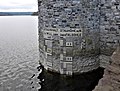
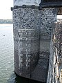
The storage or storage space of the main dam can hold 126.05 million m³ of water. With its four sections, the Möhnesee is over ten kilometers long and around 10.37 km² in size. When it is fully backed up, its deepest point is 36 meters at the Linkturm, which was named after the builder Ernst Link .
Dam wall
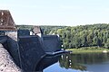
The barrier structure of the dam, which was built as a gravity dam, consists of quarry stone masonry, is built according to the Intze principle and has a crown length of 650 m.
In order to enable an overflow during floods, 105 openings are made in the top of the wall, below the roadway. Part of the energy of the water flowing down is already converted on the air side of the dam by the protruding quarry stone blocks. In order to protect the wall and because of the generation of energy, overflow through the openings of the flood relief is avoided as far as possible. The dam last overflowed in August 2007, due to extreme rainfall in the catchment area - for example in Warstein on August 9, 2007 in three hours 58.5 mm. The penultimate overflow event was in 1984.
Equalization basin and hydroelectric power station
Directly below the dam there is a compensation pool (compensation pond) that serves as a stilling pool . The storage space is 0.65 million m³ and the storage target is 183.6 m above sea level. NHN .
The hydropower plant has an expansion capacity of 7.04 MW ; its mean total annual energy production is 12.9 million kWh .
Pre-locking
The Möhnesee has three pre-locks (pre-basins); Looking down on Möhne these are:
Carrion foothills
The Möhne feeds the Möhne pre-basin directly to the east of the main dam, the storage capacity of which can hold 7 million m³ of water. The water is dammed up by the Stockumer Damm located south of Stockum , on the west side of which the main basin meets directly.
Wamel pre-basin
The Wamelvorbecken lies at the influence of the Wameler Bach in the main dam. A Lehmschüttdamm over which the county road 8 in section Völlinghausen - Wamel -Stockum leads, separating it from the main pool. The normal congestion target is 213.74 m , the summer congestion target is 212.5 m . The dam is 14 m high and about 580 m long. At the crown it is 12.65 m wide, at the foot a maximum of 75 m.
Heving basin

The Heve fore basin lies at the influence of the Heve in the main dam. It is separated from the main basin by an embankment dam, over which the federal road 229 runs in the section Breitenbruch - Delecke . The normal congestion target is at 213.74 m , the summer congestion target at 213 m . The dam is 12 m high and about 320 m long. At the crown it is 12 m wide, at the foot a maximum of 41 m. The storage space is 800,000 m³.
nature and environment

The Möhnesee is designated as a European bird sanctuary " Möhnesee " in the Natura 2000 protected area system of the EU .
The Hevesee and the Heve-Arm in the south of the Möhnesees as well as the inlet of the Möhne into the lake are designated as nature reserve Hevearm and Hevesee . The Hev pre-basin and adjacent areas have also been registered as an FFH area .
With four to six thousand water birds, the Möhnesee is an important resting place in North Rhine-Westphalia. The major catch birds, with percentages for the years 2001 to 2006 the number of pension at 31 per cent, the mallard with 24 percent, the coot with 22 percent of grebes with 9 percent who Pochard 5 percent and other species with 9 percent. An important reason for the greater number of diving ducks and coots resting is the presence of the migrating mussel in the lake. The migrating mussel forms mussel beds with several thousand animals per square meter on the stony bottom of the lake. At the influences of the Möhne and the smaller streams in the lake there are occurrences of kingfisher , gray wagtail and dipper . Their actual breeding sites are not directly on the lake, but on the tributaries. On the lakeshore breeding mallard, tufted duck, moorhen , coot, Mute Swan , Greylag Goose , Canada Goose , Egyptian Goose and grebes. The great crested grebe has its largest breeding population in Westphalia with around fifty breeding pairs on the lake. The gray heron has a breeding colony on the Westenberg in Wamel with 15 to 30 occupied eyries . The cormorant has so far only made unsuccessful breeding attempts, presumably because of human interference. The red-necked grebe has also brooded at the lake several times without success. In the little grebe, however, there have been individual successful breeds in the past. A special feature was the year-round occurrence of the eider , a sea duck , from September 2001 to December 2006. In July 2006, the first proof of breeding for North Rhine-Westphalia was provided here: a female with three teenage cubs. When the water level rose sharply in December 2006, the eider ducks could no longer reach the migrating mussel beds and left the lake. Other sea ducks also appear more frequently in the winter time.
13 fish species were found in the lake during trial fishing by the Ruhr Association . The largest stocks come from river perch with 53 percent, ruff with 20.3 percent and roach with 13.9 percent. In addition, there are great whitefish , eel , pike , pikeperch , vendace , lake trout , bream , carp , tench and chub . Lake trout and eel only occur because of an artificial population and do not reproduce naturally. There is also the muskrat .
history

Construction time and inauguration
Calculations of the future demand for drinking and service water for the growing Ruhr area in 1904 had shown that three times as much would be required of the existing dams in the Ruhr river system with a storage volume of 32.4 million m³, namely about 100 million m³ of storage space . By 1925 it was even estimated that it would have grown to almost 200 million m³. Therefore, on November 28, 1904, the general assembly of the Ruhrtalsperrenverein decided to change the statutes to build their own dams. On May 22nd, 1905, the plan to build a large dam in the Möhnetal was discussed for the first time. The Möhnetalsperre was then built between 1908 and 1912 according to plans by the government master builder Ernst Link and based on a design by the Cologne architect Franz Brantzky for the dam at a cost of 23.5 million marks and inaugurated on July 12, 1913 by the Ruhrtalsperrenverein. In the year of its inauguration, the dam was the largest dam in Europe. The former place Kettlersteich sank completely in the water. Most of the village of Delecke (Alt-Delecke) was also flooded. 140 farmsteads with 700 people had to give way to the lake.
Dam burst due to bombing in World War II


The Möhnetalsperre was in World War II by an Operation Chastise ( German corporal punishment ) mentioned British bombing raid, led by Wing Commander Guy Gibson , in the night of 16 on May 17, 1943 severely damaged.
In order to bypass the defensive systems at the reservoir, roll bombs of the Avro Lancaster type Avro Lancaster from No. 617 Squadron dropped. These roll bombs jumped over the water at a shallow angle due to their rapid rotation and jumped over the torpedo interception nets. They then hit the dam, their twist ensuring that they quickly sank to the bottom of the wall, where they then exploded at a depth of 10 to 15 meters. One of several bombs dropped in quick succession reached its destination and damaged the wall. The storage space was full at the time of the bombing raid in May 1943. This initially resulted in a small crack, which quickly expanded due to the pressure of the outflowing water masses and finally resulted in a trapezoidal gap 77 m wide and 22 m deep.
As a result of the resulting tidal wave , which poured over the Möhne into the Ruhr Valley, according to various sources, at least 1284 or even more than 1600 people died. The fatality in connection with the tidal wave furthest away from the dropping point occurred in Essen-Steele , over 100 kilometers beyond the dam. A memorial at the former Himmelpforten monastery today commemorates the dead in the catastrophe. Neheim, today a district of Arnsberg, was hit particularly hard; the tidal wave was over 12 meters high there. Most of the people died in the Möhnewiesen forced labor camp in Neheim . In Neheim there is another memorial in front of St. John's Church.
The purpose of this attack, in which the Edertalsperre and the Sorpesee were attacked at the same time , was indirectly to impair the armaments industry in the Ruhr area; the Sorpedamm was hardly damaged due to its special concrete construction with earth and stone cover.
The attack on the dam was portrayed in the 1954 British film May '43 - The Dam Busters by Michael Anderson .
reconstruction

The reconstruction of the dam wall with a contingent of several thousand workers around the clock and using the original building materials was initiated immediately after the severe damage, in spite of the very tense general material and strength situation at the time and was able to start on October 3, 1943 with the Application of the road surface on the dam crest should be completed. The rapid progress of the work was ultimately also exploited by the Nazi propaganda to demonstrate at least small successes to the war-weary population. The impact of the attack on the war economy in the Ruhr area was not as lasting as the Allies had originally hoped. They did not attack the large construction site or the then completed dam until the end of the war.
Redevelopment
From 1972 to 1979 the Möhne Reservoir was extensively renovated. By blasting was placed along the bed foundation of the dam a control passage to, from which the wall is pressed and with drainage holes was provided.
The ravages of time also gnawed at the masonry on the free side of the dam. Water penetrated the masonry through the cracks, and the onset of frost damaged stones. In the resulting cavities, seeds accumulated, germinated and formed trees and shrubs, which further damaged the wall with its roots. From 1992 to 2000 extensive renovation work was carried out on the approximately 2.5 hectare air side. Since stone and joint renovations could only be carried out in the summer half of the year, the renovation took eight years.
As with many other reservoirs, relics from days gone by can be found below the surface of the water. In the late summer of 2003, due to repair work on the gate valves in the Hev fore basin, the water level had to be lowered until the Hev basin was completely empty. The old bridge appeared with the road running over it.
The dam wall is entered as a monument in the list of monuments of the municipality of Möhnesee.
Appreciation of the building

On the occasion of the 100th anniversary of the completion of the dam in 1912, Deutsche Post AG issued a special postage stamp to the value of 90 euro cents with special postmarks and the text 100 years of Möhne dam on the first day of issue on April 4, 2013 . The design comes from the graphic designers Gerda M. and Horst F. Neumann from Wuppertal .
In 2013 the novel Nachtauge by Titus Müller will be published , which realistically and impressively brings the history of Neheim and the flood disaster from the perspective of historical or fictional characters to life and honors it with readings on site.
For the anniversary, a large number of light installations were exhibited around the compensation pond for one month under the motto of the century lights. The central element was a video installation which, on 160 × 40 meters of the quarry stone surface of the dam between the towers, used slide and video projectors to summarize 100 years of German history with the dam at the center. It was created by Britta and Wolfgang Flammersfeld.
Pulpit Bridge

The Kanzelbrücke, built in 1912, stands over the inlet area of the Möhne in the Möhne foothills, west of Völlinghausen. The building owes its name to the design of its bridge piers, which have a certain resemblance to church pulpits - there are a total of 12 pulpits. The bridge consists of five arches and has a total length of 60 meters. It was badly damaged in the Second World War and was restored to its original state in 1953. The bridge is a replacement for a previous structure with three arched stone arches, which made it possible to cross the Möhne even before the reservoir was built. The building is owned by the Ruhrverband .
Möhneseeturm

Above the Möhnsee, about one kilometer south of the Körbeck pedestrian bridge over the reservoir, stands the 42.5-meter-high Möhneseeturm. The observation tower, which costs around 500,000 euros, was erected in the summer and autumn of 2014 in an exposed location on one of the highest points near the Möhnesee. It was released in mid-December 2014; its official opening took place on May 5, 2015. The Rennweg and the Sauerland forest route lead directly past the tower with a shared route .
The viewing platform offers views of the reservoir, many parts of the municipality of Möhnesee, parts of the Arnsberg Forest nature park and over to the Haarstrang ridge . On a clear day, the view extends to the north into the Westphalian Bay to the Teutoburg Forest and to the south to the heights of the Lennegebirge .
gallery

The Kanzelbrücke at the inlet of the Möhne into the Möhnesee
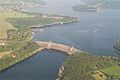
Photo of the Möhnese lake and the dam wall from the air
The Möhnetalsperre in August 2015

Möhnesee dam 2014
Level with display of height and filling quantity
Water level in September 2018, reservoir half full

Revision work on the dam


.JPG)


See also
literature
- Ralf Blank : The “Möhne catastrophe” in May 1943 as part of European war commemoration. In: Der Märker 61 (2012), pp. 97–121.
- Ralf Blank: "Ruhr Battle". The Ruhr area in the war year 1943. Essen 2013, here especially pp. 179–184.
- Helmuth Euler : “When Germany's dams broke. The truth about the bombing of the Möhne-Eder-Sorpe dams in 1943 ”. Motorbuch, Stuttgart, 1975, ISBN 3-87943-367-4 .
- Helmuth Euler: "Water War - May 17, 1943. Roll bombs against the Möhne-Eder-Sorpe dams". Self-published, Werl 1992, ISBN 3-89053-045-1 .
- Wilfried Stichmann, Ursula Stichmann-Marny: The Möhnesee. A water bird paradise through the ages. Heimatverein Möhnesee, 2008.
- Heinrich Zimmer: The Möhne Reservoir. With seven illustrations based on original photographs. In: Reclams Universum: Moderne Illustrierte Wochenschrift 27.1 (1911), pp. 367-370.
Others:
- Peter Franke, Wolfgang Frey: Dams in the Federal Republic of Germany. Systemdruck, Berlin 1987, ISBN 3-926520-00-0 .
Movies
- The Möhnetalsperre secret , WDR film by Luzia Schmid (broadcast on January 24, 2014, 8:15 p.m.) on wdr.de - teaser 1:40, descriptions
- Orangenbaum: Secret Möhne Reservoir - WDR documentary on youtube.com, published February 20, 2015, video
- The Möhnetalsperre , 18-minute film by the Ruhr Association on building history, technology and recreational value, on youtube.com
Individual evidence
- ↑ a b c Construction of the Möhnetalsperre. moehne.net, accessed June 19, 2017.
- ↑ a b c d e f g h i j k l m n o p q r Technical details: Möhne dam. Ruhrverband, accessed on June 19, 2017.
-
↑ a b c d e f g h Storage or storage spaces (in millions of m³ ; according to individual records : → Technical details: Möhnetalsperre ):
Möhnesee: 126.05 (main barrier), Möhn fore basin: 7, Hev fore basin: 0.8, compensation pond: 0 , 65; Total: 134.5 - ^ Friedrich Kühne: Geological map of North Rhine-Westphalia, sheet 4514 Möhnesee, map with explanations. Krefeld 1977, ISBN 3-86029-151-3
- ↑ Essen-Grünsand-Formation ( Memento of the original from March 4, 2016 in the Internet Archive ) Info: The archive link was inserted automatically and has not yet been checked. Please check the original and archive link according to the instructions and then remove this notice. , Lithostratigraphic Lexicon of the Federal Institute for Geosciences and Raw Materials, accessed on December 15, 2013.
- ↑ Erwitte-Formation ( Memento of the original from March 4, 2016 in the Internet Archive ) Info: The archive link was inserted automatically and has not yet been checked. Please check the original and archive link according to the instructions and then remove this notice. , Lithostratigraphic Lexicon of the Federal Institute for Geosciences and Raw Materials, accessed on December 15, 2013.
- ↑ Büren formation ( Memento of the original from March 4, 2016 in the Internet Archive ) Info: The archive link was automatically inserted and not yet checked. Please check the original and archive link according to the instructions and then remove this notice. , Lithostratigraphic Lexicon of the Federal Institute for Geosciences and Raw Materials, accessed on December 15, 2013.
- ↑ Oerlinghausen formation ( Memento of the original from March 4, 2016 in the Internet Archive ) Info: The archive link was automatically inserted and not yet checked. Please check the original and archive link according to the instructions and then remove this notice. , Lithostratigraphic Lexicon of the Federal Institute for Geosciences and Raw Materials, accessed on December 15, 2013.
- ↑ Construction and renovation measures at the Möhne dam. ( Memento from December 3, 2013 in the Internet Archive ), on archive.org, Ruhrverband (PDF file; 35 kB).
- ↑ Silvia Gängler: century lights on the dam of the Möhnesee. (No longer available online.) In: Arnsberg Neheim Hüsten News, neheim-huesten.de. Gängler Datenservice, May 4, 2013, archived from the original on December 22, 2016 ; accessed on December 21, 2016 . Info: The archive link was inserted automatically and has not yet been checked. Please check the original and archive link according to the instructions and then remove this notice.
- ↑ Möhneseeturm released ( Memento from December 21, 2014 in the Internet Archive ), on archive.org, Soest district, from December 16, 2014.
- ↑ Möhneseeturm is taking shape ( Memento from December 21, 2014 in the Internet Archive ), on archive.org. October 28, 2014
- ↑ Möhnesee tower on Rennweg in the Arnsberg Forest officially opened ( Memento of the original from June 17, 2015 in the Internet Archive ) Info: The archive link was automatically inserted and not yet checked. Please check the original and archive link according to the instructions and then remove this notice. , Soest district, on May 5, 2015, accessed on June 17, 2015.
- ↑ 360-degree panorama from the Möhneseeturm (labeling of visual targets can be activated), panorama-photo.net, accessed on September 6, 2015.
Web links
- Möhnetalsperre on ruhrverband.de
- History of the Möhnesee ( Memento from February 11, 2013 in the web archive archive.today ), from moehnesee.de
- The night of 16./17. May 1943 - "Operation Chastening": The destruction of the Möhne Dam. on lwl.org
- Dams directory North Rhine-Westphalia. State Environment Agency North Rhine-Westphalia (PDF file; 121 kB)
- Hydrograph for the dam: Möhnetalsperre (current dam level), talsperrenleitzentrale-ruhr.de
- 50 years of water bird research at the Möhnetalsperre… , Westphalia regional, lwl.org
- Description of all locations on this themed route as part of the Route of Industrial Culture
- The Möhnesee and its surroundings, leisure demands and nature conservation. lwl.org (PDF file; 1.3 MB)
- Images of the Möhne reservoir in the image archive of the LWL media center for Westphalia
- Möhnesee on the side of the natural treasures of South Westphalia
Visitor center and anchor points (from west to east): Museum of German Inland Shipping | Inner harbor Duisburg | LVR Industrial Museum Oberhausen | Landscape Park Duisburg-Nord | Gasometer Oberhausen | Aquarius Water Museum | St. Antony Hut | Villa Huegel | Nordsternpark | Zeche Zollverein World Heritage Site and Zollverein Coking Plant | Ewald colliery | Marl Chemical Park | Railway Museum Bochum-Dahlhausen | Henrichshütte | Centennial Hall Bochum | Recklinghausen substation | German Mining Museum | Nightingale colliery | Henrichenburg ship lift | DASA | Hansa coking plant | Zeche Zollern II / IV | Hohenhof | Hagen Open Air Museum | Lindenbrauerei Unna | Maximilian Park Hamm
Themed routes (in ascending order by number): 1. Duisburg: City and Harbor | 2. Industrial cultural landscape Zollverein | 3. Duisburg: industrial culture on the Rhine | 4. Oberhausen: Industry makes the city | 5. Krupp and the city of Essen | 6. Dortmund: triad coal, steel and beer | 7. Industrial culture on the Lippe | 8. Erzbahn-Emscherbruch | 9. Industrial culture at Volme and Ennepe | 10. Brine, steam and coal | 11. Early industrialization | 12. The past and present of the Ruhr | 13. On the way to the blue Emscher | 14. Canals and shipping | 15. Lanes in the area | 16. Westphalian mining route | 17. Rhenish mining route | 18. Chemistry, Glass and Energy | 19. Workers' settlements | 20. Entrepreneur villas | 21. Bread, grain and beer | 22. Myth of the Ruhr Area | 23. Parks and Gardens | 24. Industrial nature | 25. Panoramas and Landmarks | 26. Sacred buildings | 27. Iron & Steel | 28. Water: works, towers and turbines | 29. Bochum - industrial culture in the heart of the district | 30. Gelsenkirchen | 31. Industrial Culture and Bauhaus Route | by bike

Ruhrquelle |
Ramsbeck visitor mine |
Hennetalsperre |
Biggetalsperre |
Möhnetalsperre |
Sorpe dam |
Wickede run-of-river power plant |
Run-of-river power station Warm |
Schwitten run-of-river power plant |
Warm waterworks |
Upper Ruhr Valley Railway |
Chainsmith Museum |
Information center aqua publik |
Rohrmeisterei Schwerte |
Ruhr flood bridge Schwerte-Ergste |
Westhofen pumping station |
Bushmill |
Hohensyburg ![]() |
Pumped storage power plant Koepchenwerk |
Hengsteysee |
Herdecke energy industry hiking trail |
Herdecke Ruhr Viaduct |
Castle weather |
Harkort power plant |
Volmarstein community waterworks |
Villa Bönnhoff |
House Schede |
Schlebuscher Erbstollen |
Bommerholz water tower |
Mountain monument on the Hohenstein
|
Pumped storage power plant Koepchenwerk |
Hengsteysee |
Herdecke energy industry hiking trail |
Herdecke Ruhr Viaduct |
Castle weather |
Harkort power plant |
Volmarstein community waterworks |
Villa Bönnhoff |
House Schede |
Schlebuscher Erbstollen |
Bommerholz water tower |
Mountain monument on the Hohenstein ![]() |
Hohenstein hydropower plant |
Ruhr Viaduct Witten |
Steel hammer Bommern |
Mine and field railway museum Zeche Theresia |
Nightingale colliery |
Nightingale and Nightingale Bridge coal defeat |
Villa Friedrich Lohmann Sr. |
Villa Gustav Lohmann |
Villa Friedrich Lohmann jun. |
Villa Albert Lohmann |
House Berger |
Verbund waterworks Witten |
Stainless steel works Witten |
Herbede Ruhr lock |
Sunshine private distillery |
Stainless steel factory Lohmann |
Kemnader See |
Bridge Keeper's House and Lake Bridge |
Blankenstein lock and Stiepel waterworks |
Punching machine |
City Museum Hattingen |
Henrichshütte |
Ruhr Valley Railway |
Birschel mill |
House Weile and Gahlener Kohlenweg |
Towpath below the Isenberg |
Dahlhausen floating bridge |
Dahlhausen lock |
Mining Trail Dahlhausen |
Railway Museum Bochum
|
Hohenstein hydropower plant |
Ruhr Viaduct Witten |
Steel hammer Bommern |
Mine and field railway museum Zeche Theresia |
Nightingale colliery |
Nightingale and Nightingale Bridge coal defeat |
Villa Friedrich Lohmann Sr. |
Villa Gustav Lohmann |
Villa Friedrich Lohmann jun. |
Villa Albert Lohmann |
House Berger |
Verbund waterworks Witten |
Stainless steel works Witten |
Herbede Ruhr lock |
Sunshine private distillery |
Stainless steel factory Lohmann |
Kemnader See |
Bridge Keeper's House and Lake Bridge |
Blankenstein lock and Stiepel waterworks |
Punching machine |
City Museum Hattingen |
Henrichshütte |
Ruhr Valley Railway |
Birschel mill |
House Weile and Gahlener Kohlenweg |
Towpath below the Isenberg |
Dahlhausen floating bridge |
Dahlhausen lock |
Mining Trail Dahlhausen |
Railway Museum Bochum ![]() |
Dahlhausen railway station |
Villa Vogelsang |
Horster mill |
Horst lock |
Well-Safe Colliery |
Holteyer Harbor |
Dinnendahl factory | Historic sewage treatment plant Rellinghausen |
Heinrich Colliery |
Kupferdreh station and Hespertalbahn museum railway |
Deilbachtal cultural landscape with a copper hammer , geological outcrop on the Leberhofer Strasse , Eisenhammer , Deilmann farm , Deiler mill , dog bridge , Prinz-Wilhelm-Bahn , ring kiln brickworks , Victoria colliery |
Baldeneysee |
Carl Funke colliery |
Villa Huegel |
Villa Werden |
Neukircher lock |
Become an abbey |
Paper mill lock |
Kettwig reservoir |
Run-of-river power station and Kettwig lock |
Scheidt's halls |
Kettwig railway bridge |
Landsberg Castle |
Saarn Monastery |
Leather and tanning museum in the Abel leather factory |
Villa Joseph Thyssen |
J. Caspar Troost textile factory |
Mülheim Ruhr lock and Mülheim water station |
Run-of-river power plant Kahlenberg |
RWW Headquarters |
City viaduct and Ruhr bridge Mülheim |
Roundhouse Mülheim and Camera Obscura |
Mannesmannröhren-Werke |
Friedrich Wilhelms-Hütte |
Aquarius Water Museum |
Rhine-Ruhr port of Mülheim |
Raffelberg hydropower plant |
Raffelberg saltwater pool |
Ruhrschleuse Duisburg and Ruhrwehr |
Inner harbor Duisburg |
Museum of German Inland Shipping
|
Dahlhausen railway station |
Villa Vogelsang |
Horster mill |
Horst lock |
Well-Safe Colliery |
Holteyer Harbor |
Dinnendahl factory | Historic sewage treatment plant Rellinghausen |
Heinrich Colliery |
Kupferdreh station and Hespertalbahn museum railway |
Deilbachtal cultural landscape with a copper hammer , geological outcrop on the Leberhofer Strasse , Eisenhammer , Deilmann farm , Deiler mill , dog bridge , Prinz-Wilhelm-Bahn , ring kiln brickworks , Victoria colliery |
Baldeneysee |
Carl Funke colliery |
Villa Huegel |
Villa Werden |
Neukircher lock |
Become an abbey |
Paper mill lock |
Kettwig reservoir |
Run-of-river power station and Kettwig lock |
Scheidt's halls |
Kettwig railway bridge |
Landsberg Castle |
Saarn Monastery |
Leather and tanning museum in the Abel leather factory |
Villa Joseph Thyssen |
J. Caspar Troost textile factory |
Mülheim Ruhr lock and Mülheim water station |
Run-of-river power plant Kahlenberg |
RWW Headquarters |
City viaduct and Ruhr bridge Mülheim |
Roundhouse Mülheim and Camera Obscura |
Mannesmannröhren-Werke |
Friedrich Wilhelms-Hütte |
Aquarius Water Museum |
Rhine-Ruhr port of Mülheim |
Raffelberg hydropower plant |
Raffelberg saltwater pool |
Ruhrschleuse Duisburg and Ruhrwehr |
Inner harbor Duisburg |
Museum of German Inland Shipping ![]() |
Haniel Museum |
Rhine orange
|
Haniel Museum |
Rhine orange