
Marols
| Marols | ||
|---|---|---|
.svg)
|
|
|
| region | Auvergne-Rhône-Alpes | |
| Department | Loire | |
| Arrondissement | Montbrison | |
| Canton | Montbrison | |
| Community association | Loire Forez | |
| Coordinates | 45 ° 29 ' N , 4 ° 3' E | |
| height | 620-1,184 m | |
| surface | 14.94 km 2 | |
| Residents | 416 (January 1, 2017) | |
| Population density | 28 inhabitants / km 2 | |
| Post Code | 42560 | |
| INSEE code | 42140 | |
 View of Marols |
||

Marols is a French municipality with 416 inhabitants (as of January 1 2017) in the department of Loire in the region Auvergne Rhône-Alpes . It belongs to the canton of Montbrison (until 2015: canton of Saint-Jean-Soleymieux ). The inhabitants are called Marolais .
geography
Marols is about 26 kilometers west-northwest of Saint-Étienne in the Forez . Marols is surrounded by the neighboring communities of Saint-Jean-Soleymieux in the north, Chenereilles in the east, Luriecq in the south and south-east, Estivareilles in the south and south-west, Montarcher in the south-west and La Chapelle-en-Lafaye in the west.
Population development
| 1962 | 1968 | 1975 | 1982 | 1990 | 1999 | 2006 | 2013 |
|---|---|---|---|---|---|---|---|
| 404 | 344 | 295 | 285 | 310 | 331 | 369 | 418 |
| Source: Cassini and INSEE | |||||||
Attractions
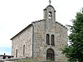
- Saint-Pierre church from the 12th century
- Saint-Roch chapel from the 17th century
- Fortification from around the 15th century

Saint-Pierre church
Saint Roch chapel

Parts of the former fortifications


Web links
Commons : Marols - collection of images, videos and audio files