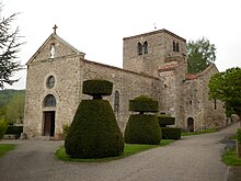
Salt-en-Donzy
| Salt-en-Donzy | ||
|---|---|---|
|
|
||
| region | Auvergne-Rhône-Alpes | |
| Department | Loire | |
| Arrondissement | Montbrison | |
| Canton | Feurs | |
| Community association | Forez-Est | |
| Coordinates | 45 ° 44 ′ N , 4 ° 17 ′ E | |
| height | 346-490 m | |
| surface | 8.93 km 2 | |
| Residents | 544 (January 1, 2017) | |
| Population density | 61 inhabitants / km 2 | |
| Post Code | 42110 | |
| INSEE code | 42296 | |
Salt-en-Donzy is a municipality in southern France . It belongs to the Auvergne-Rhône-Alpes region , the Loire department , the Montbrison arrondissement and the Feurs canton . Salt-en-Donzy borders on Salvizinet to the north, Jas to the northeast, Saint-Barthélemy-Lestra to the southeast, Valeille to the south and Feurs to the west . The Route nationale 89 affects the village.
Population development
| year | 1962 | 1968 | 1975 | 1982 | 1990 | 1999 | 2008 | 2015 |
|---|---|---|---|---|---|---|---|---|
| Residents | 244 | 278 | 346 | 374 | 412 | 393 | 493 | 543 |
Attractions
- church
Web links
Commons : Salt-en-Donzy - collection of images, videos and audio files

