
Chambles
| Chambles | ||
|---|---|---|
.svg)
|
|
|
| region | Auvergne-Rhône-Alpes | |
| Department | Loire | |
| Arrondissement | Montbrison | |
| Canton | Saint-Just-Saint-Rambert | |
| Community association | Loire Forez | |
| Coordinates | 45 ° 27 ' N , 4 ° 14' E | |
| height | 360-741 m | |
| surface | 18.9 km 2 | |
| Residents | 1,000 (January 1, 2017) | |
| Population density | 53 inhabitants / km 2 | |
| Post Code | 42170 | |
| INSEE code | 42042 | |
| Website | http://www.chambles.fr/ | |

Chambles is a French commune with a population of 1,000 (as at 1st January 2017) in the department of Loire in the region Auvergne Rhône-Alpes . It belongs to the arrondissement of Montbrison and the canton of Saint-Just-Saint-Rambert .
geography
Chambles is located in the historic Forez landscape in the Massif Central on the Loire , which is dammed up here to form Lac de Gragent and delimits the community to the east. Chambles is surrounded by the neighboring communities of Saint-Just-Saint-Rambert in the north, Saint-Victor-sur-Loire in the east, Caloire in the south, Saint-Maurice-en-Gourgois in the south and southwest, Périgneux in the west and Saint-Marcellin- en-Forez in the northwest.
Population development
| 1962 | 1968 | 1975 | 1982 | 1990 | 1999 | 2006 | 2013 |
|---|---|---|---|---|---|---|---|
| 288 | 295 | 356 | 545 | 624 | 762 | 877 | 971 |
| Source: Cassini and INSEE | |||||||
Attractions
- Saint-Pierre church
- 11th century Essalois Castle
- Tower of Chambles
- Vassalieux Castle
- Notre-Dame-des-Grâces seminar
- Le Châtelet priory
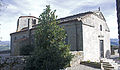
Saint-Pierre church

Essalois Castle
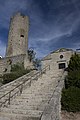
Stairway to the Tower of Chambles


