
Marcilly-le-Châtel
| Marcilly-le-Châtel | ||
|---|---|---|
.svg)
|
|
|
| region | Auvergne-Rhône-Alpes | |
| Department | Loire | |
| Arrondissement | Montbrison | |
| Canton | Boën-sur-Lignon | |
| Community association | Loire Forez | |
| Coordinates | 45 ° 42 ′ N , 4 ° 2 ′ E | |
| height | 377-708 m | |
| surface | 16.32 km 2 | |
| Residents | 1,390 (January 1, 2017) | |
| Population density | 85 inhabitants / km 2 | |
| Post Code | 42130 | |
| INSEE code | 42134 | |
| Website | http://www.marcilly-le-chatel.fr/ | |
.jpg) View of Marcilly-le-Châtel from the Sainte-Anne castle ruins |
||

Marcilly-le-Châtel (previously: Marcilly-le-Pave ) is a French municipality with 1,390 inhabitants (as of January 1 2017) in the department of Loire in the region Auvergne Rhône-Alpes . Administratively it belongs to the arrondissement of Montbrison and is part of the canton of Boën-sur-Lignon .
geography
Marcilly-le-Châtel is located about 40 kilometers northwest of Saint-Étienne in the Forez in the Massif Central . Marcilly-le-Châtel is surrounded by the neighboring communities of Marcoux in the north and west, Montverdun in the east and northeast, Chalain-d'Uzore in the east and southeast, Pralong in the south and Saint-Bonnet-le-Correau in the southwest.
Population development
| year | 1962 | 1968 | 1975 | 1982 | 1990 | 1999 | 2006 | 2013 |
|---|---|---|---|---|---|---|---|---|
| Residents | 634 | 666 | 687 | 760 | 856 | 974 | 1,175 | 1,345 |
| Source: Cassini and INSEE | ||||||||
Attractions
- Saint-Cyr church
- Castle ruins of Sainte-Anne from the 12th century
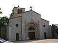
Saint-Cyr church

Castle ruins of Sainte-Anne

.JPG)
Web links
Commons : Marcilly-le-Châtel - Collection of images, videos and audio files