
Saint-Etienne-le-Molard
| Saint-Etienne-le-Molard | ||
|---|---|---|
.svg)
|
|
|
| region | Auvergne-Rhône-Alpes | |
| Department | Loire | |
| Arrondissement | Montbrison | |
| Canton | Boën-sur-Lignon | |
| Community association | Loire Forez | |
| Coordinates | 45 ° 44 ' N , 4 ° 5' E | |
| height | 338-397 m | |
| surface | 16.55 km 2 | |
| Residents | 1,019 (January 1, 2017) | |
| Population density | 62 inhabitants / km 2 | |
| Post Code | 42130 | |
| INSEE code | 42219 | |

Saint-Étienne-le-Molard is a commune in France located at 380 meters above sea level . It belongs to the Auvergne-Rhône-Alpes region , the Loire department , the Montbrison arrondissement and the Boën-sur-Lignon canton . It is bordered by Sainte-Foy-Saint-Sulpice to the north and northeast , Poncins to the southeast, Montverdun to the south and Sainte-Agathe-la-Bouteresse to the west . The residents call themselves Stéphanois.
Population development
| year | 1962 | 1968 | 1975 | 1982 | 1990 | 1999 | 2008 | 2015 |
|---|---|---|---|---|---|---|---|---|
| Residents | 627 | 620 | 659 | 630 | 625 | 751 | 907 | 1006 |
Attractions
- La Bastie d'Urfé castle
- Saint-Etienne church with stained glass by Alexandre Mauvernay
- Hall cross, Monument historique
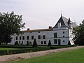
La Bastie d'Urfé castle
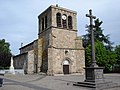
Saint-Étienne church and war memorial

,_%C3%A9glise_et_monument_aux_morts.JPG)
Web links
Commons : Saint-Étienne-le-Molard - Collection of images, videos and audio files