Craintilleux
| Craintilleux | ||
|---|---|---|
|
|
||
| region | Auvergne-Rhône-Alpes | |
| Department | Loire | |
| Arrondissement | Montbrison | |
| Canton | Andrézieux-Bouthéon | |
| Community association | Loire Forez | |
| Coordinates | 45 ° 35 ' N , 4 ° 14' E | |
| height | 348-379 m | |
| surface | 8.22 km 2 | |
| Residents | 1,328 (January 1, 2017) | |
| Population density | 162 inhabitants / km 2 | |
| Post Code | 42210 | |
| INSEE code | 42075 | |
| Website | http://www.craintilleux.fr/ | |
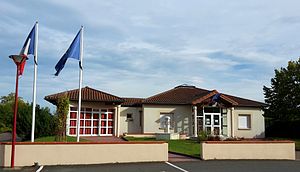
 Town hall (Mairie) of Craintilleux |
||
Craintilleux is a French commune with 1,328 inhabitants (as of January 1 2017) in the department of Loire in the region Auvergne Rhône-Alpes . It belongs to the arrondissement of Montbrison and the canton of Andrézieux-Bouthéon (until 2015: canton of Saint-Just-Saint-Rambert ).
geography
Craintilleux is located about 20 kilometers northwest of Saint-Étienne on the Loire , into which the Malbief flows, in the historic Forez landscape in the Massif Central . Craintilleux is surrounded by the neighboring communities of Unias in the north, Rivas in the east, Veauchette in the east and south-east, Saint-Cyprien in the south, Sury-le-Comtal in the south-west and L'Hôpital-le-Grand in the west and north-west.
Population development
| 1962 | 1968 | 1975 | 1982 | 1990 | 1999 | 2006 | 2013 |
|---|---|---|---|---|---|---|---|
| 346 | 322 | 403 | 668 | 752 | 900 | 1,082 | 1,223 |
| Source: Cassini and INSEE | |||||||
Attractions
- Saint-Léger church
Web links
Commons : Craintilleux - collection of images, videos and audio files

