
Châtelneuf (Loire)
| Châtelneuf | ||
|---|---|---|
|
||
| region | Auvergne-Rhône-Alpes | |
| Department | Loire | |
| Arrondissement | Montbrison | |
| Canton | Boën-sur-Lignon | |
| Community association | Loire Forez | |
| Coordinates | 45 ° 38 ′ N , 3 ° 59 ′ E | |
| height | 498–1,021 m | |
| surface | 8.48 km 2 | |
| Residents | 335 (January 1, 2017) | |
| Population density | 40 inhabitants / km 2 | |
| Post Code | 42940 | |
| INSEE code | 42054 | |
| Website | https://chatelneuf.jimdo.com/ | |
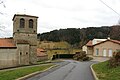
.jpg) View of Châtelneuf |
||

Châtelneuf is a French municipality with 335 inhabitants (at January 1, 2017) in the department of Loire in the region Auvergne Rhône-Alpes (before 2016 Rhône-Alpes ). Administratively it belongs to the arrondissement of Montbrison and is part of the canton Boën-sur-Lignon (until 2015 Saint-Georges-en-Couzan ).
geography
Châtelneuf is located about 38 kilometers northwest of Saint-Étienne in the Forez in the Massif Central . Châtelneuf is surrounded by the neighboring communities of Saint-Bonnet-le-Courreau in the north and west, Pralong in the north and north-east, Champdieu in the east, Essertines-en-Châtelneuf in the south and Roche in the south-west.
Population development
| year | 1962 | 1968 | 1975 | 1982 | 1990 | 1999 | 2006 | 2013 |
|---|---|---|---|---|---|---|---|---|
| Residents | 220 | 209 | 195 | 209 | 240 | 259 | 312 | 318 |
| Source: Cassini and INSEE | ||||||||
Attractions
- church
- Saint-Gilles Chapel in Fraisse, Monument historique
- Remains of the castle
Church and town hall

Chapel in Fraisse
,_mairie,_%C3%A9glise.jpg)
,_chapelle_de_Fraisse,_ext%C3%A9rieur.jpg)
Web links
Commons : Châtelneuf - collection of images, videos and audio files