
Les Salles
| Les Salles | ||
|---|---|---|
.svg)
|
|
|
| region | Auvergne-Rhône-Alpes | |
| Department | Loire | |
| Arrondissement | Montbrison | |
| Canton | Boën-sur-Lignon | |
| Community association | Pays d'Urfé | |
| Coordinates | 45 ° 51 ′ N , 3 ° 48 ′ E | |
| height | 636-963 m | |
| surface | 25.22 km 2 | |
| Residents | 541 (January 1, 2017) | |
| Population density | 21 inhabitants / km 2 | |
| Post Code | 42440 | |
| INSEE code | 42295 | |
| Website | http://www.lessalles42.fr/ | |
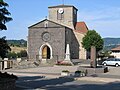
 View of Les Salles |
||

Les Salles is a French municipality with 541 inhabitants (as of January 1 2017) in the department of Loire in the region Auvergne Rhône-Alpes . Administratively it belongs to the arrondissement of Montbrison and is part of the canton Boën-sur-Lignon (until 2015: canton Noirétable ). The inhabitants are called Salards (also: Douguets ).
geography
Les Salles is located about 64 kilometers northwest of Saint-Étienne in the Forez in the Massif Central . Les Salles is surrounded by the neighboring communities of Chausseterre and Saint-Romain-d'Urfé in the north, Champoly in the east, Vêtre-sur-Anzon with Saint-Julien-la-Vêtre in the south and south-east, Noirétable in the south and south-west, and Cervières in the west and south-west, Chabreloche in the west and Arconsat in the north-west.
The A89 autoroute runs through the municipality .
Population development
| year | 1962 | 1968 | 1975 | 1982 | 1990 | 1999 | 2006 | 2013 |
|---|---|---|---|---|---|---|---|---|
| Residents | 527 | 505 | 412 | 518 | 441 | 424 | 466 | 513 |
| Source: Cassini and INSEE | ||||||||
Attractions
- Menhirs
- Remains of the Roman road from Lugdunum (Lyon) to Augustonemetum (Clermont-Ferrand)
- church
- Saint Roch chapel
- La Goutte Castle
church

La Goutte Castle

