
Cleppé
| Cleppé | ||
|---|---|---|
|
||
| region | Auvergne-Rhône-Alpes | |
| Department | Loire | |
| Arrondissement | Montbrison | |
| Canton | Feurs | |
| Community association | Forez-Est | |
| Coordinates | 45 ° 46 ′ N , 4 ° 11 ′ E | |
| height | 323-394 m | |
| surface | 15.48 km 2 | |
| Residents | 529 (January 1, 2017) | |
| Population density | 34 inhabitants / km 2 | |
| Post Code | 42110 | |
| INSEE code | 42066 | |
 Mairie Cleppé |
||

Cleppé is a French commune in the Loire department in the region of Auvergne Rhône-Alpes (before 2016 Rhône-Alpes ). It belongs to the canton of Feurs and the arrondissement of Montbrison .
geography
The municipality borders on Sainte-Foy-Saint-Sulpice to the north-west, Mizérieux to the north, Épercieux-Saint-Paul to the north-east, Civens to the east, Feurs to the south-east and Poncins to the south-west .
Attractions
- Tower of the former Cleppé Castle from the 11th and 12th centuries. A monument historique since 1971 .
- Church Nativité-de-Notre-Dame
- Hall cross at the church
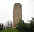
The tower of the Castle of Cleppé

church

Floor cross


Population development
| year | 1962 | 1968 | 1975 | 1982 | 1990 | 1999 | 2008 | 2015 |
|---|---|---|---|---|---|---|---|---|
| Residents | 404 | 456 | 409 | 360 | 404 | 454 | 551 | 559 |
Web links
Commons : Cleppé - collection of images, videos and audio files
Individual evidence
- ↑ Château des Comtes de Forez (restes de l'ancien). In: Mérimée database . French Ministry of Culture , accessed February 15, 2018 (French).