Nýrov
| Nýrov | ||||
|---|---|---|---|---|
|
||||
| Basic data | ||||
| State : |
|
|||
| Region : | Jihomoravský kraj | |||
| District : | Blansko | |||
| Area : | 917 ha | |||
| Geographic location : | 49 ° 32 ' N , 16 ° 33' E | |||
| Height: | 500 m nm | |||
| Residents : | 222 (Jan. 1, 2019) | |||
| Postal code : | 679 72 | |||
| License plate : | B. | |||
| traffic | ||||
| Street: | Kunštát - Letovice | |||
| structure | ||||
| Status: | local community | |||
| Districts: | 1 | |||
| administration | ||||
| Mayor : | Ivo Dvořáček (as of 2018) | |||
| Address: | Nýrov 56 679 72 Kunštát na Moravě |
|||
| Municipality number: | 582107 | |||
| Website : | www.nyrov.cz | |||
Nýrov (German Nejrow , formerly Neyrow ) is a municipality in the Czech Republic . It is located three kilometers northeast of Kunštát and belongs to the Okres Blansko .
geography
Nýrov is located on the right side above the valley of the Svitava on a plateau in the mountains of the upper Swratka . The village is located in the northeast of the Halasovo Kunštátsko Nature Park. The Sebránek stream rises to the southwest. To the north rise the Chrástky (460 m), in the east the Drábovka (469 m), southeast the Hradisko or Kojavy (496 m), in the southwest the Milenka (579 m), west the Kříb (582 m). To the east lies the Habrov desert.
Neighboring towns are Jasinov and Zábludov in the north, Lhota and Jindřichov in the northeast, Zboněk and Klevetov in the east, Sasina, Svitávka and Sebranice in the southeast, Újezd in the south, Kunštát and Rudka in the southwest, Petrov in the west and Sulíkov and Vřesice in the northwest.
history
The first written mention of the village belonging to the Sebranice estates took place in 1368 as the property of the Lords of Boskowitz . Over time, the village was known as Nérov , Nerow , Neyrow and Nejrov . In 1549 the Counts of Hardegg acquired the village; they detached Nýrov from Sebranice and added it to their rule of art town . In 1590 the heiresses of Hans Friedrich zu Hardegg on Glatz sold Kunstadt with all accessories to Johann zu Hardegg and Stettenberg on Letovice , who in the same year sold the rule on to Johanna Eva von Liechtenstein . During the Thirty Years War the village of Habrov became extinct and its corridors came to Nýrov. In the hoof register of 1677 twelve properties are shown for Nýrov, three of which were desolate. In 1790 181 people lived in the 30 houses of the village.
After the abolition of patrimonial Nejrov formed from 1850 a municipality in the district administration Boskovice . The residents of the village lived from working in the fields and forests. A third of the agricultural land in the village belonged to the Meierhof Neyrow. In 1900 Nejrov had 230 inhabitants and consisted of 32 houses. In 1908 a primary school was built in Nejrov. With the construction of the road from Kunštát to Letovice, Nejrov received a road connection in 1914. In the 1920s, the large estate and the Meierhof were divided. The settlement Nýrovec was built to the southwest of the farm. Since 1923 the village has been called Nýrov . During the German occupation, part of the Yermak partisan group was in the woods on Hradisko. In January 1945 the Gestapo excavated the hiding place, and four partisans died. Two of the residents of the village were arrested for collaborating with the partisans.
After the end of the war, a mine was built near Nýrov in which refractory clay was extracted. At the beginning of 1961 the community was assigned to the Okres Blansko . In 1977 it was incorporated into Kunštát and the school was closed in the 1980s. 1990 Nýrov broke away from Kunštát. The village has always been parish after Sebranice. Nýrov now consists of 85 houses.
Community structure
No districts are shown for the municipality of Nýrov. The settlement of Nýrovec belongs to Nýrov.
Attractions
- Hradisko hill with ramparts, probably the foundations of an unrealized castle from the 13th century, some researchers attribute a prehistoric origin to them. After the forested hill was partially cleared, the Hradisko now has a clear view over the valley of the Nýrovský potok or Sebránek and Sebranice into the Boskowitz furrow .
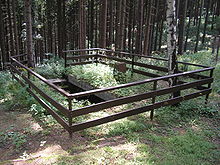
- "Partyzánská zemljanka" (a dwelling cave of the resistance fighters) in the forest east of the Hradisko, the earth house was built in the 1970s on the place of the hiding place of the partisan group Jermak as a memorial of the resistance against the National Socialists and was repaired in 2001.
- Křib Hill, at the eastern foot there is an extensive sandstone quarry and at the southwest an old plan quarry with fossilized prints of sea creatures.
- Milenka hill with a lookout tower and the Rudka sandstone cave, the sandstone figures of the Sleeping Knights from Blaník were created by folk artist Stanislav Rolínek in the 1920s


