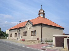
Skalice nad Svitavou
| Skalice nad Svitavou | ||||
|---|---|---|---|---|
|
||||
| Basic data | ||||
| State : |
|
|||
| Region : | Jihomoravský kraj | |||
| District : | Blansko | |||
| Area : | 300 ha | |||
| Geographic location : | 49 ° 29 ' N , 16 ° 36' E | |||
| Height: | 330 m nm | |||
| Residents : | 612 (Jan. 1, 2019) | |||
| Postal code : | 679 01 | |||
| License plate : | B. | |||
| traffic | ||||
| Street: | Boskovice - Drnovice | |||
| Railway connection: |
Brno – Česká Třebová Chornice – Skalice nad Svitavou |
|||
| structure | ||||
| Status: | local community | |||
| Districts: | 1 | |||
| administration | ||||
| Mayor : | Petr Řezníček (as of 2018) | |||
| Address: | Skalice nad Svitavou 48 679 01 Skalice nad Svitavou |
|||
| Municipality number: | 582336 | |||
| Website : | Skalice.svazeksvitava.cz | |||
Skalice nad Svitavou (German Skalitz an der Zwittawa ) is a municipality in the Czech Republic . It is located four kilometers west of Boskovice and belongs to the Okres Blansko .
geography
Skalice nad Svitavou is located at the western foot of the Drahaner Bergland in the Boskowitz furrow . The village extends to the right of the Svitava at the confluence of the Výpustek and Úmoří streams. The Bělá flows into the Svitava south-east of Skalice. The Habří (451 m) rises to the northeast, the Rovná (446 m) to the east, the Faberka (445 m) to the southeast, the Na Kamencích (428 m) to the south, the Hůry (470 m) and the Chlum (511 m) to the west m) as well as the Podsedky (421 m) to the northwest. State road I / 43 / E461 runs west of the village ; Here it crosses the embankments of the unfinished Vienna-Wroclaw Reichsautobahn , on which the road I / 150 leads north of Skalice to Boskovice.
Neighboring towns are Vaculka and Svitávka in the north, Chrudichromy , Mladkov and Boskovice in the northeast, Pilský Dvůr in the east, Újezd u Boskovic and Lhota Rapotina in the southeast, Jabloňany and Krhov in the south, Lysice and Drnovice in the southwest, Voděrady in the north-west Sebranice .
history
Archaeological finds prove a settlement of the municipality area since the Paleolithic . This was discovered in 1979 during excavation work for the new construction of a farm; it existed until the 7th century BC. The first written mention of the place belonging to Gau Úsobrno took place in 1228 as the property of the Velké Opatovice priory . Between 1341 and 1348 Ješek von Doubravice auf Skalice was named as the owner of the place. In 1505 Ladislav Velen von Boskowitz and his wife Magdalena von Dubá and Lipá acquired the property and joined them to the Boskovice dominion . In 1547 the Boskowitzers sold the rule to Simon Eder von Sstiawnicz ( Šimon Eder ze Štiavnice ). In 1569 the Zástřizl family acquired the property. After the lords of Zástřízl became extinct in the male line, Susanne von Zástřízl sold the Boskowitz reign in 1689 to Count Walther von Dietrichstein . In 1730 the Kaiserstraße from Brno to Bohemia was built west of the village , on the route of which the state road I / 43 runs today. Between 1843 and 1848 the state built the railway line Brno - Bohemian Trübau along the Svitava on the eastern edge of the village as part of the Imperial and Royal Northern State Railway . The trains initially ran past Skalice without stopping; a train station was only set up later. Until the middle of the 19th century, Skalice always remained subservient to Boskovice.
After the replacement of patrimonial, Skalice formed from 1850 a municipality in the district administration Boskovice . In 1852 the Zlatá studna post office was established in Vaculca. After the Dietrichstein family died out, the goods fell to Count Mensdorff-Pouilly in 1864 . In 1887 the place was flooded by the Úmoří flood. In 1902 the railway line to Chornice was inaugurated by the Skalitz-Boskowitz-Großopatowitz local railway . In the same year the syringe house was built. In 1933 there was a partial regulation of the Úmoří. In the years 1939 to 1941, construction work was carried out to the northwest of the village for the Vienna-Wroclaw Reichsautobahn . Since 1948 the municipality has been using the name Skalice nad Svitavou to distinguish it from places of the same name . Skalice nad Svitavou has belonged to Okres Blansko since the beginning of 1961 . The village to Doubravice nad Svitavou is parish .
Community structure
No districts are shown for the municipality of Skalice nad Svitavou.
Attractions
- Chapel of the Virgin Mary, Helper of Christians , built in 1926 instead of a previous building from 1888
- Rovná Castle, east of the village on the mountain of the same name
- several crossroads


