
Alf (Moselle)
| coat of arms | Germany map | |
|---|---|---|

|
Coordinates: 50 ° 3 ' N , 7 ° 7' E |
|
| Basic data | ||
| State : | Rhineland-Palatinate | |
| County : | Cochem cell | |
| Association municipality : | Zell (Moselle) | |
| Height : | 95 m above sea level NHN | |
| Area : | 6.33 km 2 | |
| Residents: | 832 (Dec. 31, 2019) | |
| Population density : | 131 inhabitants per km 2 | |
| Postal code : | 56859 | |
| Area code : | 06542 | |
| License plate : | COC, ZEL | |
| Community key : | 07 1 35 001 | |
| Association administration address: | Corray 1 56856 Zell (Moselle) |
|
| Website : | ||
| Mayoress : | Miriam Giardini-Molzahn | |
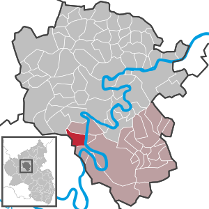
| Location of the local community Alf in the district of Cochem-Zell | ||
  |
||


Alf is a municipality in the Cochem-Zell district in Rhineland-Palatinate . It belongs to the Verbandsgemeinde Zell (Mosel) .
geography
At Alf, the Alfbach flows into the Moselle on the left, coming from the districts of Höllenthal and Fabrik . Another district is the older Alf-Fabrik industrial site to the west. Neighboring towns include St. Aldegund , Bullay on the right bank and Pünderich, which is also on the right bank of the Moselle but - due to the Moselle loop - south 2 km as the crow flies . The area of the local community covers 6.33 km², of which 0.67 km² is vineyards and 3.79 km² is forest.
history
Inhabited by Celts in pre-Roman times , the name goes back to the Roman settlement Albis (first mentioned around 50 BC). In the Middle Ages, Alf belonged to the rule of the nearby Arras Castle , which in turn was a fiefdom of Kurtrier . From 1794 Alf was under French rule and until 1814 belonged to Mairie Eller in the canton of Cochem . In 1815 the place was assigned to the Kingdom of Prussia at the Congress of Vienna .
Since 1946 the place has been part of the then newly formed state of Rhineland-Palatinate.
- Statistics on population development
The development of the population of the municipality of Alf, the values from 1871 to 1987 are based on censuses:
|
|
Municipal council
The municipal council in Alf consists of twelve council members, who were elected by a majority vote in the local elections on May 26, 2019 , and the honorary local mayor as chairman.
The distribution of seats in the municipal council:
| choice | SPD | CDU | WGR | total |
|---|---|---|---|---|
| 2019 | by majority vote | 12 seats | ||
| 2014 | 6th | 3 | 3 | 12 seats |
| 2009 | 5 | 4th | 3 | 12 seats |
| 2004 | 4th | 4th | 4th | 12 seats |
Culture and sights
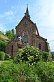
The Arras Castle , founded in the early 12th century, is located above the village . The Marienburg , which belongs to Zell , is also nearby . The town's landmark is the bell tower built in 1734, originally part of the baroque parish church, today free-standing as a kind of campanile next to the parish hall, since the old parish church was demolished and rebuilt in 1892–94. The new parish church of St. Remigius , made of quarry stone, has rich neo-Gothic furnishings. On the church forecourt, a statue from the 15th century shows the motif " Christ resting ", next to it is a neo-Gothic crucifixion group.

Arras Castle

Old church tower
Parish Church of St. Remigius

Neo-Gothic crucifixion group

_Alter_Kirchturm.JPG)
_Katholische_Kirche_St._Remigius.JPG)

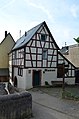
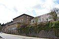
The historic town center extends around the bell tower on the Auf Kockert street. In the old schoolhouse, a half-timbered building from the early 17th century, there is a small museum of local history, which also provides information about the industrial history of the place. Diagonally opposite on a small village square rises the former Kurtrier administrative building built in the 16th century as a three-storey stone building. The roof was renewed around 1620. Particularly old buildings have also been preserved in the area between Willburgstrasse and Brunnenstrasse. A late medieval Burgmannenhaus at Willburgstrasse 5 was dated to 1448 and is probably the oldest house in the town. The massive half-timbered house at Brunnenstrasse 1 on the corner of Ferdinand-Remy-Strasse dates from around 1600.
Old school house

Kurtrierisches Amtshaus

Late medieval Burgmannenhaus

Half-timbered house
_Auf_Kockert_10.JPG)
_Kurtrierisches_Amtshaus_1.JPG)
_Willburgstra%C3%9Fe_5.JPG)
_Brunnenstra%C3%9Fe_1.JPG)
The former Thurn- und Taxische Hof in Koblenzerstraße 18 (around 1810) and the classicist villas and houses in Straße Auf der Hill, located on a hill between the Alf river and the Moselle, date from the 19th century. The striking mountain chapel in the vineyards above the village also dates from this period. The main streets of the town, the Kirch, the Ferdinand-Rémy and Bridge Street were at the time of the turn of the century to the 20th century, especially with late nineteenth built buildings such as the late historicist residential and commercial building Ferdinand-Remy-Strasse 1 (1902). In addition, villa buildings such as the Art Nouveau villa Auf Kockert 14 (around 1900) directly above the church or the classifying mansard hipped roof building Auf Tannerd 7 (1920s) high above the Moselle were built.

Former Thurn and Taxischer Hof
Late classical cellar building

Wilhelminian style residential and commercial building

Classifying villa
_Koblenzer_Stra%C3%9Fe_18.JPG)
_Auf_der_Hill_4-5-2016-1.JPG)
_Ferdinand-Remy-Stra%C3%9Fe_1.JPG)
_Auf_Tannerd_7-01.JPG)

Today's Prinzenkopf tower at the narrowest point of the Moselle loop "Zeller Hamm", which is already in the municipality of Pünderich, dates from 2009 . The fourth observation tower at this point offers a wide view over both ends of the Moselle loop between Bullay and Pünderich as well as over Kondelwald and Hunsrück heights .
Economy and Infrastructure
economy
The largest employer in Alf and the region is the Finnish packaging group Huhtamaki , which has one of its around 70 plants worldwide in the Alf-Fabrik district. Rigid plastics are produced here using the deep-drawing process and hard paper for packaging purposes .
traffic
Across from Alf is the larger town of Bullay with a train station on the Koblenz – Trier railway line , easily accessible via the Alf-Bullay double-decker bridge . Alf is the traffic junction of federal highways 49 and 53 .
Personalities
Born in Alf
- Wilhelm von Arras (* around 1310; † after 1353), Cathedral Chapter in Trier
- Peter Anton Juley (1862–1937), postal assistant (telegraph operator), art photographer and official photographer of Theodore Roosevelt
- Ferdinand Weeser-Krell (1883–1957), painter and graphic artist
- Jo Niemeyer (* 1946), graphic artist, designer and painter
Associated with Alf
- Ewald Drathen (1901–1993), wine wholesaler and member of the state parliament ( CDU )
- Ferdinand Remy (1788–1848), councilor and ironworks owner (Alf factory)
Oddities
After the great success of the American television series Alf and the start of German broadcasting in early 1988, Alf's place-name sign was stolen several times , similar to the Fuckings case . To prevent thefts, the community of Alf finally offered to buy place-name signs that were printed on one side especially for this purpose. So that these signs could be distinguished from the dismantled ones, these purchase signs were provided with the municipal stamp and the signature of the mayor at the time, Wilhelm Nicolay, on the back.
Web links
- The website of the parish
- War memorial in Alf (English)
- Ehrenstaette Prinzenkopf above Alf
- Literature about Alf in the Rhineland-Palatinate State Bibliography
Individual evidence
- ↑ State Statistical Office of Rhineland-Palatinate - population status 2019, districts, communities, association communities ( help on this ).
- ↑ State Statistical Office Rhineland-Palatinate - regional data
- ^ The Regional Returning Officer Rhineland-Palatinate: Local elections 2019, city and municipal council elections
- ^ Burghart Schmidt, Helmtrud Köhren-Jansen, Klaus Freckmann: Small house history of the Moselle landscape . Cologne 1989, pp. 212-217.
- ↑ The Melmacer made a small village famous , Berliner Kurier , May 2, 1997.

Alf | Alflen | Altlay | Alt-trimmed | Auderath | Bad Bertrich | Beilstein | Beuren | Binningen | Blankenrath | Brachtendorf | Bremm | Briedel | Brieden | Briedern | Brohl | Bruttig-Fankel | Büchel | Bullay | Cochem | Dohr | Durfus | Düngenheim | Ediger-Eller | Ellenz-Poltersdorf | Eppenberg | Serious | Eulgem | Faid | Felt | Forst (Eifel) | Forst (Hunsrück) | Gamling | Gevenich | Gillenbeuren | Greimersburg | Grenderich | Hambuch | Haserich | Hauroth | Hesweiler | Illerich | Kaifenheim | Kail | Kaisersesch | Kalenborn | Kliding | Klotten | Country core | Laubach | Leienkaul | Lie | Liesenich | Lütz | Lutzerath | Masburg | Mesenich | Medium- bodied | Möntenich | Moritzheim | Mosel core | Tired (Moselle) | Müllenbach | Neef | Nehren | Panzweiler | Peterswald -öffelscheid | Pomerania | Pünderich | Reidenhausen | Roes | Sankt Aldegund | Showers | Schmitt | Senheim | Sosberg | Tellig | Treis cards | Elms | Urmersbach | Urschmitt | Valwig | Wagenhausen | Walhausen | Hamlet | Wirfus | Wollmerath | Zell (Mosel) | Zettingen