
Ardon (Loiret)
| Ardon | ||
|---|---|---|
.svg)
|
|
|
| region | Center-Val de Loire | |
| Department | Loiret | |
| Arrondissement | Orleans | |
| Canton | La Ferté-Saint-Aubin | |
| Community association | Portes de Sologne | |
| Coordinates | 47 ° 47 ' N , 1 ° 52' E | |
| height | 98-123 m | |
| surface | 53.65 km 2 | |
| Residents | 1,117 (January 1, 2017) | |
| Population density | 21 inhabitants / km 2 | |
| Post Code | 45160 | |
| INSEE code | 45006 | |
| Website | http://www.ardon45.fr/ | |

Ardon is a French commune with 1,117 inhabitants (as of January 1 2017) in the department of Loiret in the region Center-Val de Loire . It belongs to the Arrondissement Orléans and the canton La Ferté-Saint-Aubin . The inhabitants are called Ardonnais .
geography
Ardon is about 13 kilometers south of Orléans . Ardon is surrounded by the neighboring communities of Olivet in the north, Orléans in the northeast, Saint-Cyr-en-Val in the east, La Ferté-Saint-Aubin in the south and southeast, Jouy-le-Potier in the south and southwest, Mézières-lez-Cléry in the west and Saint-Hilaire-Saint-Mesmin in the north-west.
The A71 autoroute runs along the western edge of the municipality .
Population development
| year | 1962 | 1968 | 1975 | 1982 | 1990 | 1999 | 2008 | 2013 |
| Residents | 372 | 348 | 536 | 700 | 731 | 851 | 1,113 | 1,099 |
| Source: Cassini and INSEE | ||||||||
Attractions
- 19th century church Saint-Pierre
- Boisgibault Castle from the 17th century, monument historique since 2001
- several castles and mansions

Saint-Pierre church
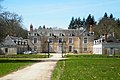
Boisgibault Castle


Web links
Commons : Ardon - collection of images, videos and audio files