
Aurach (district of Ansbach)
| coat of arms | Germany map | |
|---|---|---|

|
Coordinates: 49 ° 15 ' N , 10 ° 25' E |
|
| Basic data | ||
| State : | Bavaria | |
| Administrative region : | Middle Franconia | |
| County : | Ansbach | |
| Height : | 439 m above sea level NHN | |
| Area : | 36.67 km 2 | |
| Residents: | 2982 (Dec. 31, 2019) | |
| Population density : | 81 inhabitants per km 2 | |
| Postal code : | 91589 | |
| Area code : | 09804 | |
| License plate : | AN , DKB, FEU, ROT | |
| Community key : | 09 5 71 114 | |
| Community structure: | 12 parts of the community | |
| Address of the municipal administration: |
Im Mooshof 4 91589 Aurach |
|
| Website : | ||
| First Mayor : | Simon Göttfert ( ZBG ) | |
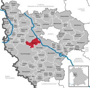
| Location of the municipality of Aurach in the district of Ansbach | ||
  |
||

Aurach is a municipality in the Central Franconian district of Ansbach .
geography
Geographical location
The community is located between Altmühl and Frankenhöhe about halfway from Ansbach to Feuchtwangen . The community area extends in the east partly to the banks of the Altmühl and extends westward over the headwaters of the Wieseth to a little beyond the Sulzach .
The eponymous main town is located about three kilometers west of the Altmühl at the foot of the ridge that separates the wide valley from the Wieseth catchment area. The village flowing through Small Aurach drained by the well Large Herzogenaurach -called Great Aurach Bach outside the church for Altmühl. The district seat of Ansbach is about 13 km northeast of the village.
Neighboring communities
Community structure
The municipality has 12 officially named municipal parts (the type of settlement is indicated in brackets ):
|
There are also the Elbleinsmühle and Schutzmühle residential areas, neither of which are officially designated parts of the community.
climate
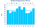
Diagram of precipitation averages Aurach for the period from 1961 to 1990


In Aurach, the average annual rainfall is 789 mm.
history
Until the church is planted
The place was first mentioned in 1123 as "Uraha". The place name is derived from the name of the water body, whose defining word is “ūr” ( mhd. For aurochs ) and whose basic word is “ahe” (mhd. For river). It was used to designate a river on which aurochs went to water.
After 1310, today's municipality came into the possession of the Hochstift Eichstätt , which was part of the Franconian Empire from 1500 . Since the Reichsdeputationshauptschluss of 1803 the place like large parts of Franconia belongs to Bavaria (see also history of Franconia )
With the community edict (early 19th century), the tax district Aurach was formed, to which the places Hilsbach , Stadel and Wahrberg belonged. A little later the rural community was formed with Hilsbach and Wahrberg . It was subject to the Herrieden district court in terms of administration and jurisdiction . The community originally had an area of 13.644 km².
According to a listing from 1830, the place belonged to an extensive forest area between Leutershausen and Sulz Monastery with the main town Brunst, called "the Brünst" or "the Brunst", which has been cleared in places since the Middle Ages . The Brünst was known for its good cattle breeding; their 22 settlements were considered rich.
Incorporations
On July 1, 1972, part of the former municipality of Büchelberg was incorporated. On May 1, 1978, the formerly independent municipality of Weinberg was added as part of the municipal reform .
Population development
In the period from 1988 to 2018, the population increased from 2,500 to 2,916 by 416 inhabitants or by 16.6%.
Aurach community
| year | 1818 | 1840 | 1852 | 1861 | 1867 | 1871 | 1875 | 1880 | 1885 | 1890 | 1895 | 1900 | 1905 | 1910 | 1919 | 1925 | 1933 | 1939 | 1946 | 1950 | 1961 | 1970 | 1987 | 1995 | 2005 | 2015 |
|---|---|---|---|---|---|---|---|---|---|---|---|---|---|---|---|---|---|---|---|---|---|---|---|---|---|---|
| Residents | 797 | 789 | 785 | 746 | 742 | 742 | 782 | 773 | 797 | 768 | 756 | 721 | 741 | 790 | 810 | 740 | 758 | 722 | 975 | 1107 | 987 | 1097 | 2469 | 2804 | 3000 | 2902 |
| Houses | 149 | 153 | 153 | 158 | 156 | 161 | 172 | 198 | 681 | 900 | ||||||||||||||||
| source |
Aurach part of the municipality
| year | 1818 | 1840 | 1861 | 1871 | 1885 | 1900 | 1925 | 1950 | 1961 | 1970 | 1987 |
|---|---|---|---|---|---|---|---|---|---|---|---|
| Residents | 639 | 647 | 617 | 601 | 643 | 601 | 605 | 944 | 880 | 1007 | 1145 |
| Houses | 129 | 125 | 134 | 132 | 143 | 152 | 177 | 333 | |||
| source |
politics
Municipal council
The Aurach municipal council has 14 members.
| CSU | UWG | FWV | UBW | total | |
| 2002 | 4th | 4th | 6th | 14 seats | |
| 2008 | 8th | 6th | 14 seats | ||
In the local elections in 2002, an association made up of the CSU and the Independent Voting Association (UWG) won four seats, the Free Voters' Association (FWV) four seats and the Independent Citizens Weinberg (UBW) six seats. In the 2008 local elections , the future alliance of the municipality of Aurach, an association of the CSU, UWG and FWV, won eight seats, while the UBW was able to defend its six seats. In addition to the mayor, the Aurach municipal council has six female and eight male members.
Local election 2014:
- Future alliance municipality Aurach: 8
- Independent Citizens Vineyard: 6
badges and flags
The municipality of Aurach has had a coat of arms since 1984.
|
|
Blazon : “ Divided by gold and red; above a red armed black aurochs , below diagonally crossed a silver sword and a silver key , topped with a vertical golden arrow . "
Red-yellow-black municipal flag |
| Foundation of the coat of arms: The municipality of Aurach has consisted of the formerly independent municipalities of Aurach and Weinberg since 1978. The aurochs stands for the place name. From 1310 to 1796 the towns were under the Eichstätt monastery . The colors gold and red of the Eichstätter cathedral chapter as well as silver and red of the bishopric are reminiscent of this long lasting connection. Sword and key are the attributes of Paul and Peter and represent the parish church in Aurach, which is dedicated to these saints. The arrow is the attribute of St. Aegidius and points to the former St. Aegidius parish church in Weinberg (today: Church of the Seven Sorrows of Mary). |
Partner communities
- Dorfhain in Saxony
- Aurach near Kitzbühel (Austria)
- Aurach am Hongar (Austria)
- Velké Karlovice in East Moravia (Czech Republic)
Sponsorship
- In 1984 the sponsorship for the expelled Sudeten Germans from the community of Blumenau in the district of Zwittau (Schönhengstgau) was taken over.
Culture and sights

Museums
- Vogteimuseum
Architectural monuments
- Historic town hall from 1375 and 1510
- Wahrberg Castle
- Parish church of St. Peter and Paul in Aurach
- Parish Church of the Seven Sorrows of Mary in vineyard
- Filial church Mater dolo rosa in Windshofen
- Chapel To Our Lady in Hilsbach
- St. Vitus Chapel in Eyerlohe
- Aurach Castle , Vogtei, today town hall
traffic
The state road 1066 heads northeast to the junction 50 of the motorway 6 or southwest to the vineyard . Communal roads lead to Elbersroth , Stadel , Dietenbronn and Eyerlohe .
Aurach is connected to the district town of Ansbach , the large district town of Dinkelsbühl and the neighboring communities with bus routes 804 and 805 . In the evenings and on weekends, there is a collective taxi to the train station in Ansbach.
Sons and daughters of the church
- Johann Anton von Zehmen (* 1715 at Wahrberg Castle near Aurach, † 1790 in Eichstätt) was bishop of the Eichstätt diocese and prince-bishop of the Eichstätt monastery from 1781 to 1790. The former primary and partial secondary school (1st – 6th grade) and today's primary school (1st – 4th grade) today bears the name Johann-Anton-von-Zehmen-Grundschule.
- Franz Dauer (1873–1937), born in Weinberg, railroad worker and politician (BVP), member of the Reichstag
- Father Reinhold Brumberger, long-time Franciscan missionary in Bolivia (South America), born in Dietenbronn
literature
- Johann Kaspar Bundschuh : Aurach . In: Geographical Statistical-Topographical Lexicon of Franconia . tape 1 : A-egg . Verlag der Stettinische Buchhandlung, Ulm 1799, DNB 790364298 , OCLC 833753073 , Sp. 203-204 ( digitized version ).
- Hans Karlmann Ramisch: District Feuchtwangen (= Bavarian art monuments . Volume 21 ). Deutscher Kunstverlag, Munich 1964, DNB 453909426 , p. 21-25 .
- Wolf-Armin von Reitzenstein : Lexicon of Franconian place names. Origin and meaning . Upper Franconia, Middle Franconia, Lower Franconia. CH Beck, Munich 2009, ISBN 978-3-406-59131-0 , p. 29 .
- Pleikard Joseph Stumpf : Aurach . In: Bavaria: a geographical-statistical-historical handbook of the kingdom; for the Bavarian people . Second part. Munich 1853, p. 732 ( digitized version ).
Web links
- Aurach community
- Map of the municipality of Aurach on the BayernAtlas
- Aurach in the Topographia Franconiae of the University of Würzburg , accessed on September 16, 2019.
- Aurach (district of Ansbach): Official statistics of the LfStat
Individual evidence
- ↑ "Data 2" sheet, Statistical Report A1200C 202041 Population of the municipalities, districts and administrative districts 1st quarter 2020 (population based on the 2011 census) ( help ).
- ↑ Retrieved May 19, 2020 .
- ^ Municipality of Aurach in the local database of the Bavarian State Library Online . Bavarian State Library, accessed on September 16, 2019.
- ↑ W.-A. v. Reitzenstein, p. 29.
- ↑ Johannes Neumann: The Reichsdeputationshauptschluss of 1803: Requirements and consequences (PDF file; 179 kB)
- ^ Address and statistical manual for the Rezatkreis in the Kingdom of Baiern . Buchdruckerei Chancellery, Ansbach 1820, p. 45 ( digitized version ).
- ↑ a b c Bavarian State Statistical Office (ed.): Official city directory for Bavaria, territorial status on October 1, 1964 with statistical information from the 1961 census . Issue 260 of the articles on Bavaria's statistics. Munich 1964, DNB 453660959 , Section II, Sp. 773 ( digitized version ).
- ^ Friedrich Oechsle: Contributions to the history of the peasant war in the Swabian-Franconian borderlands , Heilbronn 1830, p. 320, footnote, Friedrich Benedict Weber: Comments and notes on various objects of agriculture , Leipzig 1815, p. 194; Heinrich Wilhelm Bensen : Brief description and history of the city of Rotenburg ob der Tauber , Erlangen 1856, p. 29.
- ^ Wilhelm Volkert (ed.): Handbook of Bavarian offices, communities and courts 1799–1980 . CH Beck, Munich 1983, ISBN 3-406-09669-7 , p. 461 .
- ^ Federal Statistical Office (ed.): Historical municipality directory for the Federal Republic of Germany. Name, border and key number changes in municipalities, counties and administrative districts from May 27, 1970 to December 31, 1982 . W. Kohlhammer, Stuttgart / Mainz 1983, ISBN 3-17-003263-1 , p. 707 .
- ↑ a b Only inhabited houses are given. In 1818 these were designated as fireplaces , in 1840 as houses and from 1871 to 2015 as residential buildings.
- ↑ a b Alphabetical index of all the localities contained in the Rezatkreise according to its constitution by the newest organization: with indication of a. the tax districts, b. Judicial Districts, c. Rent offices in which they are located, then several other statistical notes . Ansbach 1818, p. 7 ( digitized version ). For the municipality of Aurach plus the residents and buildings of Hilsbach (p. 40) and Wahrberg (p. 98).
- ^ A b Eduard Vetter (Ed.): Statistical handbook and address book of Middle Franconia in the Kingdom of Bavaria . Self-published, Ansbach 1846, p. 156 ( digitized version ). According to the historical municipality register 1953, the municipality had 785 inhabitants.
- ^ A b c d e f g h i Bavarian State Statistical Office (Hrsg.): Historical municipality directory: The population of the municipalities of Bavaria from 1840 to 1952 (= contributions to Statistics Bavaria . Issue 192). Munich 1954, DNB 451478568 , p. 171 , urn : nbn: de: bvb: 12-bsb00066439-3 ( digitized ).
- ↑ a b Joseph Heyberger, Chr. Schmitt, v. Wachter: Topographical-statistical manual of the Kingdom of Bavaria with an alphabetical local dictionary . In: K. Bayer. Statistical Bureau (Ed.): Bavaria. Regional and folklore of the Kingdom of Bavaria . tape 5 . Literary and artistic establishment of the JG Cotta'schen Buchhandlung, Munich 1867, Sp. 1023 , urn : nbn: de: bvb: 12-bsb10374496-4 ( digitized version ).
- ↑ Kgl. Statistisches Bureau (Ed.): Directory of the municipalities of the Kingdom of Bavaria according to the status of the population in December 1867 . XXI. Issue of the contributions to the statistics of the Kingdom of Bavaria. Ackermann, Munich 1869, p. 160 ( digitized version ).
- ↑ a b Kgl. Statistical Bureau (ed.): Complete list of localities of the Kingdom of Bavaria. According to districts, administrative districts, court districts and municipalities, including parish, school and post office affiliation ... with an alphabetical general register containing the population according to the results of the census of December 1, 1875 . Adolf Ackermann, Munich 1877, 2nd section (population figures from 1871, cattle figures from 1873), Sp. 1187 , urn : nbn: de: bvb: 12-bsb00052489-4 ( digitized version ).
- ↑ K. Bayer. Statistical Bureau (ed.): Community directory for the Kingdom of Bavaria. Manufactured due to the new organization of government districts, district offices and judicial districts. Addendum to issue 36 of the articles on Bavaria's statistics. Munich 1879, p. 63 ( digitized version ).
- ↑ K. Bayer. Statistical Bureau (ed.): Community directory for the Kingdom of Bavaria. Results of the census of December 1, 1880. Issue 35 of the articles on Bavaria's statistics. Munich 1882, p. 180 ( digitized version ).
- ↑ a b K. Bayer. Statistical Bureau (Ed.): Localities directory of the Kingdom of Bavaria. According to government districts, administrative districts, ... then with an alphabetical register of locations, including the property and the responsible administrative district for each location. LIV. Issue of the contributions to the statistics of the Kingdom of Bavaria. Munich 1888, Section III, Sp. 1119 ( digitized version ).
- ↑ a b K. Bayer. Statistical Bureau (Ed.): Directory of localities of the Kingdom of Bavaria, with alphabetical register of places . LXV. Issue of the contributions to the statistics of the Kingdom of Bavaria. Munich 1904, Section II, Sp. 1187 ( digitized version ).
- ↑ a b Bavarian State Statistical Office (ed.): Localities directory for the Free State of Bavaria according to the census of June 16, 1925 and the territorial status of January 1, 1928 . Issue 109 of the articles on Bavaria's statistics. Munich 1928, Section II, Sp. 1224 ( digitized version ).
- ↑ a b Bavarian State Statistical Office (ed.): Official place directory for Bavaria - edited on the basis of the census of September 13, 1950 . Issue 169 of the articles on Bavaria's statistics. Munich 1952, DNB 453660975 , Section II, Sp. 1053 ( digitized version ).
- ↑ a b Bavarian State Statistical Office (Hrsg.): Official local directory for Bavaria . Issue 335 of the articles on Bavaria's statistics. Munich 1973, DNB 740801384 , p. 167 ( digitized version ).
- ↑ a b Bavarian State Office for Statistics and Data Processing (Ed.): Official local directory for Bavaria, territorial status: May 25, 1987 . Issue 450 of the articles on Bavaria's statistics. Munich November 1991, DNB 94240937X , p. 324 ( digitized version ).
- ^ Aurach (district of Ansbach): Official statistics of the LfStat
- ↑ http://www.aurach.de/seite/de/gemeinde/035:105:360/-/Gremien_und_Ausschuesse.html
- ^ Entry on the coat of arms of Aurach (district of Ansbach) in the database of the House of Bavarian History
- ↑ Aurach. In: Kommunalflaggen.eu. Retrieved March 6, 2020 .

Adelshofen | Arberg | Aurach | Bechhofen | Bruckberg | Book at the forest | Burgoberbach | Burk | Colmberg | Dentlein am Forst | Diebach | Dietenhofen | Dinkelsbühl | Dombühl | Dürrwangen | Ehingen | Feuchtwangen | Flachslanden | Gebsattel | Gerolfingen | Geslau | Heilsbronn | Herrieden | Insingen | Langfurth | Lehrberg | Leutershausen | Lichtenau | Merkendorf | Mitteleschenbach | Mönchsroth | Neuendettelsau | Neusitz | Oberdachstetten | Ohrbach | Ornbau | Petersaurach | Röckingen | Rothenburg ob der Tauber | Rügland | Saxony near Ansbach | Schillingsfürst | Schnelldorf | Schopfloch | Steinsfeld | Unterschwaningen | Wassertrüdingen | Weidenbach | Weihenzell | Weiltingen | Wettringen | Wieseth | Wilburgstetten | Windelsbach | Windsbach | Wittelshofen | Wolframs-Eschenbach | Wörnitz
Unregulated areas:
Lower Forest