Bouloire
| Bouloire | ||
|---|---|---|

|
|
|
| region | Pays de la Loire | |
| Department | Sarthe | |
| Arrondissement | Mamers | |
| Canton | Saint-Calais | |
| Community association | Gesnois Biluria | |
| Coordinates | 47 ° 58 ' N , 0 ° 33' E | |
| height | 98-176 m | |
| surface | 26.77 km 2 | |
| Residents | 2,082 (January 1, 2017) | |
| Population density | 78 inhabitants / km 2 | |
| Post Code | 72440 | |
| INSEE code | 72042 | |
| Website | [1] | |
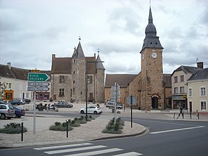
 Place in front of the castle and the church |
||
Bouloire is a French commune with 2,082 inhabitants (as of January 1 2017) in the Sarthe department in the region of Pays de la Loire . It belongs to the arrondissement of Mamers and the canton of Saint-Calais (until 2015: canton of Bouloire ). The inhabitants are called biluria .
geography
Bouloire is located about 26 kilometers east-southeast of Le Mans on the small Maunon river . Bouloire is surrounded by the neighboring municipalities of Le Breil-sur-Mérize in the north and north-west, Saint-Michel-de-Chavaignes in the north and north-east, Coudrecieux in the east, Écorpain in the south-east, Maisoncelles in the south, and Saint-Mars-de-Locquenay in the south and south-west, Volnay in the south-west and Surfonds in the west.
The former route nationale 157 (today's D357) runs through the municipality .
Population development
| year | 1962 | 1968 | 1975 | 1982 | 1990 | 1999 | 2006 | 2012 |
| Residents | 1,660 ° | 1,532 | 1,433 | 1,594 | 1,829 | 1,883 | 1,989 | 2,081 |
Attractions
- Saint-Georges church from the 12th century, rebuilt in the 17th century
- Saint-Sébastien Chapel, built before 1680, rebuilt around 1850
- Castle from the 15th and 16th centuries
literature
- Le Patrimoine des Communes de la Sarthe. Flohic Editions, Volume 1, Paris 2000, ISBN 2-84234-106-6 , pp. 269-271.
