
La Chapelle-Huon
| La Chapelle-Huon | ||
|---|---|---|
|
||
| region | Pays de la Loire | |
| Department | Sarthe | |
| Arrondissement | Mamers | |
| Canton | Saint-Calais | |
| Community association | Vallées de la Braye et de l'Anille | |
| Coordinates | 47 ° 51 ' N , 0 ° 45' E | |
| height | 67-156 m | |
| surface | 18.65 km 2 | |
| Residents | 547 (January 1, 2017) | |
| Population density | 29 inhabitants / km 2 | |
| Post Code | 72310 | |
| INSEE code | 72064 | |

La Chapelle-Huon is a French municipality with 547 inhabitants (as of January 1 2017) in the department of Sarthe in the region Pays de la Loire ; it belongs to the arrondissement of Mamers and the canton of Saint-Calais . The inhabitants are called Capellhuonnais .
geography
La Chapelle-Huon is about 35 kilometers east-south-east of Le Mans . La Chapelle-Huon is surrounded by the neighboring communities of Saint-Gervais-de-Vic in the north, Savigny-sur-Braye in the north-east, Bonneveau in the south-east, Bessé-sur-Braye in the south, Vancé in the south-west and Cogners in the west and north-west.
Population development
| 1962 | 1968 | 1975 | 1982 | 1990 | 1999 | 2006 | 2013 |
|---|---|---|---|---|---|---|---|
| 563 | 511 | 503 | 458 | 537 | 591 | 525 | 545 |
| Source: Cassini and INSEE | |||||||
Attractions
- Saint-André church, historique monument since 1926
- Mill Guillaume
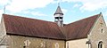
Saint-André church

Mill Guillaume


Community partnerships
A partnership exists with the German municipality of Kirchdorf in Lower Saxony.
Web links
Commons : La Chapelle-Huon - Collection of images, videos and audio files