
Saint-Mars-la-Brière
| Saint-Mars-la-Brière | ||
|---|---|---|
.svg)
|
|
|
| region | Pays de la Loire | |
| Department | Sarthe | |
| Arrondissement | Mamers | |
| Canton | Savigné-l'Évêque | |
| Community association | Gesnois Biluria | |
| Coordinates | 48 ° 2 ′ N , 0 ° 22 ′ E | |
| height | 52-133 m | |
| surface | 34.69 km 2 | |
| Residents | 2,688 (January 1, 2017) | |
| Population density | 77 inhabitants / km 2 | |
| Post Code | 72470 | |
| INSEE code | 72300 | |

Saint-Mars-la-Brière is a French commune in the department of Sarthe in the region Pays de la Loire . It belongs to the arrondissement of Mamers and the canton of Savigné-l'Évêque (until 2015: canton of Montfort-le-Gesnois ). On January 1, 2017, the municipality had 2,688 inhabitants called Briérois .
geography
Saint-Mars-la-Brière is about 15 kilometers east of Le Mans on the Huisne River . Saint-Mars-la-Brière is surrounded by the neighboring communities of Saint-Corneille in the north, Montfort-le-Gesnois in the northeast, Soulitré in the east, Ardenay-sur-Mérize in the southeast, Parigné-l'Évêque in the south, Changé in the southwest, Champagné in the west and Fatines in the northwest.
The Saint-Mars-la-Brière train station is on the Paris – Brest railway line . The A11 autoroute as well as the former Routes nationales 23 (today D323) and 157 (today D357) lead through the municipality .
Population development
| 1962 | 1968 | 1975 | 1982 | 1990 | 1999 | 2006 | 2012 |
|---|---|---|---|---|---|---|---|
| 1,587 | 1,743 | 1.915 | 2.157 | 2,271 | 2,360 | 2,389 | 2,510 |
Attractions
- Saint-Médard church from the 16th century
- Saint-Denis-du-Tertre chapel from the 11th and 17th centuries
- Saint-Mars Castle
- Archaeological dig site of a prehistoric settlement

Saint-Médard church

Saint-Denis-du-Tertre chapel
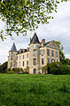
Saint-Mars Castle


