
Sougé-le-Ganelon
| Sougé-le-Ganelon | ||
|---|---|---|
|
||
| region | Pays de la Loire | |
| Department | Sarthe | |
| Arrondissement | Mamers | |
| Canton | Sillé-le-Guillaume | |
| Community association | Haute Sarthe Alpes Mancelles | |
| Coordinates | 48 ° 19 ′ N , 0 ° 2 ′ W | |
| height | 77-198 m | |
| surface | 18.11 km 2 | |
| Residents | 901 (January 1, 2017) | |
| Population density | 50 inhabitants / km 2 | |
| Post Code | 72130 | |
| INSEE code | 72337 | |
| Website | http://www.souhabenanelon.fr/ | |

Sougé-le-Ganelon is a French municipality with 328 inhabitants (as of January 1 2017) in the department of Sarthe in the region Pays de la Loire . It belongs to the arrondissement of Mamers and the canton of Sillé-le-Guillaume (until 2015: canton of Fresnay-sur-Sarthe ).
geography
Sougé-le-Ganelon is located about 35 kilometers north-northwest of Le Mans . The Sarthe flows through the municipality . Sougé-le-Ganelon is surrounded by the neighboring municipalities of Saint-Léonard-des-Bois in the north and north-west, Assé-le-Boisne in the north and east, Douillet in the south, Saint-Georges-le-Gaultier in the south-west and Saint-Paul- le-Gaultier in the west. The parish is part of the Normandy-Maine Regional Nature Park .
Population development
| year | 1962 | 1968 | 1975 | 1982 | 1990 | 1999 | 2006 | 2013 |
| Residents | 884 | 856 | 838 | 793 | 723 | 810 | 971 | 887 |
| Source: Cassini and INSEE | ||||||||
Attractions
- Dolmen
- Saint-Martin church from 11th / 12th centuries century
- Former priory

Dolmen

Saint Martin Church
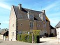
Saint Martin Priory


literature
- Le Patrimoine des Communes de la Sarthe. Flohic Editions, Volume 1, Paris 2000, ISBN 2-84234-106-6 , pp. 634-635.