Vibraye
| Vibraye | ||
|---|---|---|

|
|
|
| region | Pays de la Loire | |
| Department | Sarthe | |
| Arrondissement | Mamers | |
| Canton | Saint-Calais | |
| Community association | Vallées de la Braye et de l'Anille | |
| Coordinates | 48 ° 4 ′ N , 0 ° 44 ′ E | |
| height | 107-199 m | |
| surface | 43.62 km 2 | |
| Residents | 2,553 (January 1, 2017) | |
| Population density | 59 inhabitants / km 2 | |
| Post Code | 72320 | |
| INSEE code | 72373 | |
| Website | http://www.vibraye.fr/ | |
Vibraye is a French commune in the department of Sarthe in the region Pays de la Loire . It belongs to the canton of Saint-Calais in the arrondissement of Mamers . In Vibraye live 2553 inhabitants (as of January 1, 2017) on an area of 43.62 km².
geography
Vibraye is 40 kilometers east of Le Mans and 70 kilometers southwest of Chartres at an altitude between 107 and 199 meters. The Braye , a tributary of the Loir, flows through the village .
Partner municipality
Vibraye is a partner community of the Lower Saxony community of Wagenfeld .
traffic
The Autoroute A11 (= E 50 ) from Paris to Le Mans runs north 11 km away; the Autoroute A28 (= E 502) from Le Mans to Tours runs to the west in a distance of 33 km.
Attractions
- Ruins of the Gué-de-Launay Abbey
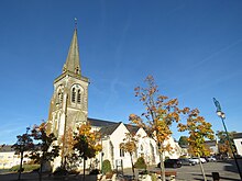
- Saint-Jean-Baptiste church
- Castle (built 1879)
Web links
Commons : Vibraye - collection of images, videos and audio files

