
Courcival
| Courcival | ||
|---|---|---|
|
||
| region | Pays de la Loire | |
| Department | Sarthe | |
| Arrondissement | Mamers | |
| Canton | Bonnétable | |
| Community association | Maine Saosnois | |
| Coordinates | 48 ° 14 ' N , 0 ° 24' E | |
| height | 62-93 m | |
| surface | 8.94 km 2 | |
| Residents | 96 (January 1, 2017) | |
| Population density | 11 inhabitants / km 2 | |
| Post Code | 72110 | |
| INSEE code | 72102 | |
 Courcival Town Hall (Mairie) |
||

Courcival is a French municipality with 96 inhabitants (as at 1st January 2017) in the department of Sarthe in the region Pays de la Loire . The municipality is located in the arrondissement of Mamers and in the canton of Bonnétable . Its inhabitants are called Courcivalois .
geography
Courcival is about 28 kilometers north-northeast of Le Mans and about 31 kilometers southeast of Alençon . Courcival is surrounded by the neighboring communities of Peray in the north and north-west, Nauvay in the north, Saint-Cosme-en-Vairais in the east and north-east, Rouperroux-le-Coquet in the east, Terrehault in the south and south-east, Jauzé in the south and Saint-Aignan in the West and southwest.
Population development
| 1962 | 1968 | 1975 | 1982 | 1990 | 1999 | 2006 | 2013 |
|---|---|---|---|---|---|---|---|
| 188 | 130 | 92 | 98 | 65 | 80 | 82 | 88 |
| Source: Cassini and INSEE | |||||||
Attractions
- Saint-Brice church from the 11th century
- Courcival castle from the 17th century, monument historique since 2011
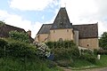
Saint-Brice church
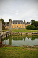
Courcival Castle


literature
- Le Patrimoine des Communes de la Sarthe. Flohic Editions, Volume 1, Paris 2000, ISBN 2-84234-106-6 , pp. 239-241.
Web links
Commons : Courcival - collection of images, videos and audio files