
Domfront-en-Champagne
| Domfront-en-Champagne | ||
|---|---|---|
|
||
| region | Pays de la Loire | |
| Department | Sarthe | |
| Arrondissement | Mamers | |
| Canton | Loué | |
| Community association | Champagne Conlinoise et Pays de Sillé | |
| Coordinates | 48 ° 6 ′ N , 0 ° 2 ′ W | |
| height | 77-172 m | |
| surface | 20.97 km 2 | |
| Residents | 1,034 (January 1, 2017) | |
| Population density | 49 inhabitants / km 2 | |
| Post Code | 72240 | |
| INSEE code | 72119 | |

Domfront-en-Champagne is a French commune with 1,034 inhabitants (as of January 1 2017) in the department of Sarthe in the region Pays de la Loire . It belongs to the arrondissement of Mamers and the canton of Loué (until 2015: canton of Conlie ). The inhabitants are called Domfrontais .
geography
Domfront-en-Champagne is about 16 kilometers northwest of Le Mans . Domfront-en-Champagne is surrounded by the neighboring communities of Conlie in the north and west, Mézières-sous-Laverdin in the north and north-east, Sainte-Sabine-sur-Longève in the north-east, La Chapelle-Saint-Fray in the east, La Milesse in the south-east, Lavardin in the south and Cures in the south and southwest.
The municipality's train station is on the Paris – Brest railway line .
Population development
| year | 1962 | 1968 | 1975 | 1982 | 1990 | 1999 | 2006 | 2013 |
| Residents | 813 | 753 | 666 | 720 | 850 | 936 | 964 | 1,017 |
| Source: Cassini and INSEE | ||||||||
Attractions
- Roman military camp from the time of the Gallic War
- Saint-Front church, a historic monument since 1939
- Notre-Dame chapel in L'Habit, monument historique since 1972
- Rectory, monument historique since 1992
- L'Habit mansion, a historic monument since 1944

Saint-Front church
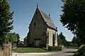
Notre-Dame chapel


literature
- Le Patrimoine des Communes de la Sarthe. Flohic Editions, Volume 1, Paris 2000, ISBN 2-84234-106-6 , pp. 413-416.