
Torcé-en-Vallée
| Torcé-en-Vallée | ||
|---|---|---|
|
||
| region | Pays de la Loire | |
| Department | Sarthe | |
| Arrondissement | Mamers | |
| Canton | Savigné-l'Évêque | |
| Community association | Gesnois Biluria | |
| Coordinates | 48 ° 8 ' N , 0 ° 24' E | |
| height | 71-146 m | |
| surface | 16.86 km 2 | |
| Residents | 1,409 (January 1, 2017) | |
| Population density | 84 inhabitants / km 2 | |
| Post Code | 72110 | |
| INSEE code | 72359 | |
 Town hall (Mairie) of Torcé-en-Vallée |
||

Torcé-en-Vallée is a French commune with 1,409 inhabitants (as of January 1 2017) in the department of Sarthe in the region Pays de la Loire . It belongs to the arrondissement of Mamers and the canton of Savigné-l'Évêque (until 2015: canton of Montfort-le-Gesnois ). The inhabitants are called Torcéens .
geography
Torcé-en-Vallée is located about 20 kilometers northeast of Le Mans on Vive Parence . Torcé-en-Vallée is surrounded by the neighboring communities of Beaufay in the north and west, Briosne-lès-Sables in the north, Bonnétable in the northeast, Saint-Célerin in the east, Lombron in the south and Sillé-le-Philippe in the southwest.
Population development
| year | 1962 | 1968 | 1975 | 1982 | 1990 | 1999 | 2006 | 2013 |
| Residents | 1.003 | 969 | 808 | 819 | 784 | 811 | 1.107 | 1,354 |
| Source: Cassini and INSEE | ||||||||
Attractions
- Dolmen
- Notre-Dame church from the 12th century, alterations from the 16th century, monument historique since 1926/2003
- Remains of the castle of Les Aulnays
- Le Chesnay Castle from the 19th century
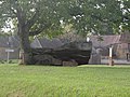
Dolmen

Notre-Dame church

Castle of Les Aulnays


Personalities
- Éric Huchet (* 1962), opera singer (tenor)
Web links
Commons : Torcé-en-Vallée - collection of images, videos and audio files