
Le Tronchet (Sarthe)
| Le Tronchet | ||
|---|---|---|
|
||
| region | Pays de la Loire | |
| Department | Sarthe | |
| Arrondissement | Mamers | |
| Canton | Sillé-le-Guillaume | |
| Community association | Haute Sarthe Alpes Mancelles | |
| Coordinates | 48 ° 11 ' N , 0 ° 5' E | |
| height | 58-130 m | |
| surface | 3.89 km 2 | |
| Residents | 163 (January 1, 2017) | |
| Population density | 42 inhabitants / km 2 | |
| Post Code | 72170 | |
| INSEE code | 72362 | |

Le Tronchet is a French municipality with 163 inhabitants (as of January 1 2017) in the department of Sarthe in the region Pays de la Loire ; it belongs to the arrondissement of Mamers and the canton of Sillé-le-Guillaume . The inhabitants are called Tronchetois .
geography
Le Tronchet is located about 20 kilometers north-northwest of Le Mans . Le Tronchet is surrounded by the neighboring municipalities of Assé-le-Riboul in the north, Saint-Marceau in the east, Saint-Jean-d'Assé in the south and south-east and Mézières-sous-Lavardin in the west and south-west.
Population development
| 1962 | 1968 | 1975 | 1982 | 1990 | 1999 | 2006 | 2013 |
|---|---|---|---|---|---|---|---|
| 149 | 138 | 147 | 141 | 128 | 105 | 131 | 149 |
| Source: Cassini and INSEE | |||||||
Attractions
- Notre-Dame church
- Le Tronchet Castle, Monument historique

Notre-Dame church
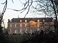
lock


literature
- Le Patrimoine des Communes de la Sarthe. Flohic Editions, Volume 1, Paris 2000, ISBN 2-84234-106-6 , pp. 194-198.
Web links
Commons : Le Tronchet - collection of images, videos and audio files