
Saint-Gervais-de-Vic
| Saint-Gervais-de-Vic | ||
|---|---|---|
.svg)
|
|
|
| region | Pays de la Loire | |
| Department | Sarthe | |
| Arrondissement | Mamers | |
| Canton | Sillé-le-Guillaume | |
| Community association | Vallées de la Braye et de l'Anille | |
| Coordinates | 47 ° 53 ' N , 0 ° 44' E | |
| height | 75-153 m | |
| surface | 16.03 km 2 | |
| Residents | 395 (January 1, 2017) | |
| Population density | 25 inhabitants / km 2 | |
| Post Code | 72120 | |
| INSEE code | 72286 | |

Saint-Gervais-de-Vic is a French municipality with 395 inhabitants (as of January 1 2017) in the department of Sarthe in the region Pays de la Loire ; it belongs to the arrondissement of Mamers and the canton of Saint-Calais . The inhabitants are called Gervaisiens .
geography
Saint-Gervais-de-Vic is located about 40 kilometers east-southeast of Le Mans . Saint-Gervais-de-Vic is surrounded by the neighboring communities of Saint-Calais in the north, Savigny-sur-Braye in the east, La Chapelle-Huon in the south, Cogners in the west and south-west and Sainte-Cérotte in the west and north-west.
Population development
| 1962 | 1968 | 1975 | 1982 | 1990 | 1999 | 2006 | 2013 |
|---|---|---|---|---|---|---|---|
| 580 | 490 | 478 | 419 | 402 | 399 | 387 | 394 |
| Source: Cassini and INSEE | |||||||
Attractions
- Saint-Gervais-et-Saint-Protais church, monument historique since 1927
- La Béchuère mansion from the 15th century, a historic monument since 1979
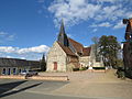
Saint-Gervais-et-Saint-Protais church
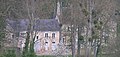
La Béchuère manor house


Web links
Commons : Saint-Gervais-de-Vic - Collection of images, videos and audio files