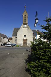
Saint-Maixent (Sarthe)
| Saint-Maixent | ||
|---|---|---|
|
|
||
| region | Pays de la Loire | |
| Department | Sarthe | |
| Arrondissement | Mamers | |
| Canton | Saint-Calais | |
| Community association | Pays de l'Huisne Sarthoise | |
| Coordinates | 48 ° 5 ' N , 0 ° 39' E | |
| height | 75-197 m | |
| surface | 22.48 km 2 | |
| Residents | 740 (January 1, 2017) | |
| Population density | 33 inhabitants / km 2 | |
| Post Code | 72320 | |
| INSEE code | 72296 | |
 Town hall (Mairie) of Saint-Maixent |
||
Saint-Maixent is a French municipality with 740 inhabitants (as of January 1 2017) in the department of Sarthe in the region Pays de la Loire . It belongs to the arrondissement of Mamers and the canton of Saint-Calais (until 2015: canton of Montmirail ). The inhabitants are called Saint-Maixentais .
geography
Saint-Maixent is about 33 kilometers east-northeast of Le Mans . Saint-Maixent is surrounded by the neighboring communities of Villaines-la-Gonais in the north and north-west, Cherré-Au with Cherré in the north, Cormes in the north-east, Lamnay in the east, Lavaré in the south and south-east, Bouër in the south and south-west, Le Luart in the west and south-west and Sceaux-sur-Huisne to the west and north-west.
Population development
| year | 1962 | 1968 | 1975 | 1982 | 1990 | 1999 | 2006 | 2013 |
| Residents | 872 | 844 | 692 | 574 | 614 | 668 | 743 | 738 |
| Source: Cassini and INSEE | ||||||||
Attractions
- Saint-Maixent church from the 16th century
- 19th century castle Le Logis
Personalities
- Jacques-François Villiers (1727–1794), doctor, encyclopaedist and translator
Web links
Commons : Saint-Maixent - Collection of images, videos and audio files

