Sillé-le-Guillaume
| Sillé-le-Guillaume | ||
|---|---|---|
|
|
||
| region | Pays de la Loire | |
| Department | Sarthe | |
| Arrondissement | Mamers | |
| Canton | Sillé-le-Guillaume (main town) | |
| Community association | Champagne Conlinoise et Pays de Sillé | |
| Coordinates | 48 ° 11 ′ N , 0 ° 8 ′ W | |
| height | 115-260 m | |
| surface | 12.9 km 2 | |
| Residents | 2,305 (January 1, 2017) | |
| Population density | 179 inhabitants / km 2 | |
| Post Code | 72140 | |
| INSEE code | 72334 | |
| Website | http://www.sille-le-guillaume.fr | |
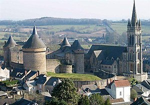
 Castle and church in Sillé-le-Guillaume |
||
Sillé-le-Guillaume is a French commune with 2,305 inhabitants (at January 1, 2017) in the department of Sarthe in the region Pays de la Loire . It belongs to the arrondissement of Mamers and is the main town in the canton of Sillé-le-Guillaume .
geography
The community is located around 30 kilometers northwest of Le Mans in the Normandy-Maine Regional Nature Park on the border with the Mayenne department . Neighboring municipalities are Mont-Saint-Jean in the north, Saint-Rémy-de-Sillé in the east, Rouez in the south, Rouessé-Vassé in the southwest, Le Grez in the west and Saint-Pierre-sur-Orthe (Mayenne department) in the northwest.
Population development
| year | 1968 | 1975 | 1982 | 1990 | 1999 | 2006 |
| Residents | 2,528 | 2,777 | 2,863 | 2,583 | 2,585 | 2,360 |
Community partnerships
-
St. Pantaleon-Erla in Lower Austria
The relationship between the Musikverein Erla and Sillé le Guillaume, near Le Mans, France, resulted in an official partnership between the two communities of St. Pantaleon-Erla and Sillé-le-Guillaume in 1990. - Somerton in the English county of Somerset
Personalities
- Victor Hémery (* 1876 in Sillé-le-Guillaume, † 1950 in Le Mans ), racing car driver
Web links
Commons : Sillé-le-Guillaume - collection of images, videos and audio files
Individual evidence
- ^ Association chronicle of the Musikverein Erla. Retrieved August 7, 2015 .
