
Villaines-la-Carelle
| Villaines-la-Carelle | ||
|---|---|---|
|
||
| region | Pays de la Loire | |
| Department | Sarthe | |
| Arrondissement | Mamers | |
| Canton | Mamers | |
| Community association | Maine Saosnois | |
| Coordinates | 48 ° 23 ' N , 0 ° 18' E | |
| height | 128-341 m | |
| surface | 14.7 km 2 | |
| Residents | 152 (January 1, 2017) | |
| Population density | 10 inhabitants / km 2 | |
| Post Code | 72600 | |
| INSEE code | 72374 | |

Villaines-la-Carelle is a French municipality with 152 inhabitants (as of January 1 2017) in the department of Sarthe in the region Pays de la Loire ; it belongs to the Arrondissement of Mamers and the Canton of Mamers . The inhabitants are called Villainois .
geography
Villaines-la-Carelle is located about 53 kilometers north-northeast of Le Mans and about 20 kilometers east-southeast of Alençon in the valley of the Bienne . Villaines-la-Carelle is surrounded by the neighboring communities of Louzes in the north, Aillières-Beauvoir in the north and east, Saint-Longis in the southeast, Vezot in the south, Saint-Rémy-du-Val in the southwest, Neufchâtel-en-Saosnois in the west as well Villeneuve-en-Perseigne in the north-west. The parish is part of the Normandy-Maine Regional Nature Park .
Population development
| 1962 | 1968 | 1975 | 1982 | 1990 | 1999 | 2006 | 2013 |
|---|---|---|---|---|---|---|---|
| 322 | 279 | 266 | 204 | 175 | 167 | 174 | 161 |
| Source: Cassini and INSEE | |||||||
Attractions
- Saint-Rémy church from the 16th century
- Rectory from the 17th century

St. Remigius Church
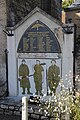
Fallen memorial
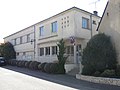
Mairie from Villaines-la-Carelle

Lavoir


