
Saint-Mars-de-Locquenay
| Saint-Mars-de-Locquenay | ||
|---|---|---|
|
||
| region | Pays de la Loire | |
| Department | Sarthe | |
| Arrondissement | Mamers | |
| Canton | Saint-Calais | |
| Community association | Gesnois Biluria | |
| Coordinates | 47 ° 56 ' N , 0 ° 29' E | |
| height | 102-167 m | |
| surface | 21.78 km 2 | |
| Residents | 570 (January 1, 2017) | |
| Population density | 26 inhabitants / km 2 | |
| Post Code | 72440 | |
| INSEE code | 72298 | |
 Town hall (Mairie) of Saint-Mars-de-Locquenay |
||

Saint-Mars-de-Locquenay is a French municipality with 570 inhabitants (as of January 1 2017) in the department of Sarthe in the region Pays de la Loire . It belongs to the arrondissement of Mamers and the canton of Saint-Calais (until 2015: canton of Bouloire ). The inhabitants are called Loquenaysia .
geography
Saint-Mars-de-Locquenay is located about 25 kilometers east-southeast of Le Mans . Saint-Mars-de-Locquenay is surrounded by the neighboring communities of Volnay in the north and west, Bouloire in the north and north-east, Maisoncelles in the east and north-east, Tresson in the east and south-east, Villaines-sous-Lucé in the south and Challes in the west and south-west.
Population development
| year | 1962 | 1968 | 1975 | 1982 | 1990 | 1999 | 2006 | 2013 |
| Residents | 565 | 482 | 421 | 431 | 406 | 432 | 514 | 541 |
| Source: Cassini and INSEE | ||||||||
Attractions
- Saint-Mars church from the 16th century
- Saint-Silouane Orthodox Monastery
- Le Chesnaye Castle, Monument historique since 1997

Saint-Mars church

Saint-Silouane monastery
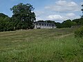
La Chesnaye Castle


literature
- Le Patrimoine des Communes de la Sarthe. Flohic Editions, Volume 1, Paris 2000, ISBN 2-84234-106-6 , p. 277.
Web links
Commons : Saint-Mars-de-Locquenay - Collection of images, videos and audio files