
Saint-Michel-de-Chavaignes
| Saint-Michel-de-Chavaignes | ||
|---|---|---|
|
||
| region | Pays de la Loire | |
| Department | Sarthe | |
| Arrondissement | Mamers | |
| Canton | Saint-Calais | |
| Community association | Gesnois Biluria | |
| Coordinates | 48 ° 1 ′ N , 0 ° 34 ′ E | |
| height | 78-158 m | |
| surface | 18.37 km 2 | |
| Residents | 737 (January 1, 2017) | |
| Population density | 40 inhabitants / km 2 | |
| Post Code | 72440 | |
| INSEE code | 72303 | |
 Town hall (Mairie) of Saint-Michel-de-Chavaignes |
||

Saint-Michel-de-Chavaignes is a French municipality with 737 inhabitants (as of January 1 2017) in the department of Sarthe in the region Pays de la Loire . It belongs to the arrondissement of Mamers and the canton of Saint-Calais (until 2015: canton of Bouloire ). The inhabitants are called Chavaignais .
geography
Saint-Michel-de-Chavaignes is located about 29 kilometers east of Le Mans on the banks of the small river Dué , which is also called Nogue here . Saint-Michel-de-Chavaignes is surrounded by the neighboring communities of Dollon in the north and east, Coudrecieux in the south and south-east, Bouloire in the south and south-west, Le Breil-sur-Mérize in the west and Thorigné-sur-Dué in the west and north-west.
Population development
| year | 1962 | 1968 | 1975 | 1982 | 1990 | 1999 | 2006 | 2013 |
| Residents | 902 | 817 | 748 | 682 | 702 | 740 | 750 | 772 |
| Source: Cassini and INSEE | ||||||||
Attractions
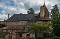
- Saint-Michel church, a historic monument since 1952
- Lassay Castle from the 18th century

Saint-Michel church
Lassay Castle

.jpg)
Personalities
- Hélène Bertaux (1825–1909), sculptor
literature
- Le Patrimoine des Communes de la Sarthe. Flohic Editions, Volume 1, Paris 2000, ISBN 2-84234-106-6 , pp. 278-280.