
District of Cloppenburg
| coat of arms | Germany map |
|---|---|

|

Coordinates: 52 ° 55 ' N , 7 ° 54' E |
| Basic data | |
| State : | Lower Saxony |
| Administrative headquarters : | Cloppenburg |
| Area : | 1,418.45 km 2 |
| Residents: | 170,682 (Dec. 31, 2019) |
| Population density : | 120 inhabitants per km 2 |
| License plate : | CLP |
| Circle key : | 03 4 53 |
| NUTS : | DE948 |
| Circle structure: | 13 municipalities |
| Address of the district administration: |
Eschstrasse 29 49661 Cloppenburg |
| Website : | |
| District Administrator : | Johann Wimberg ( CDU ) |
| Location of the district of Cloppenburg in Lower Saxony | |
  |
|
The district of Cloppenburg ( Low German : District of Cloppenborg , Sater Frisian : Loundkring Kloppenbuurich ) is located in northwestern Lower Saxony .
geography
location

The extension of the circle is north-south about 50 km and east-west 40 km. The area is flatland with an average altitude of 30–40 m above sea level. To the north of Cloppenburg, the Soeste forms an approximately 3 km long lake, the Thülsfeld dam . The district is part of the Oldenburger Münsterland region .
The IfAG operated a geodetic satellite station near Cloppenburg until the 1970s .
Neighboring areas
The district borders clockwise in the north, beginning with the districts Ammerland , Oldenburg , Vechta , Osnabrück , Emsland and Leer .
geology
In the district Geest alternate with peat soils (see also Oldenburger Land and Landkreis Oldenburg ).
Cultural landscape
The southern half of the district lies within the geographical landscape of the Ems-Hunte-Geest , divided into the Hümmling part in the west from Lindern (Oldenburg) to Friesoythe -Markhausen, in the central Cloppenburger Geest and in the edge area of the Delmenhorster Geest north of Emstek on the eastern edge of the circle. In the south of the Geest range, a narrow strip from Löningen to Essen / Oldenburg belongs to the geographic landscape of Artland . The area north and northwest of the Geest from Garrel to Barßel is part of the Leda-Jümme lowland .
climate

The district is located in the temperate climate zone of Lower Saxony in the transition area between the maritime climate of the North Sea coast and the continental climate in the south and east and is characterized by a temperate maritime climate, influenced by wet north-westerly winds from the North Sea.
temperature
The data published by Hoffmeister (1937) from the measuring station in Löningen / Cloppenburg district, about 21 km away from the city of Cloppenburg, serve to illustrate the temperature conditions . The annual mean temperature is 8.4 ° C. The maximum of the monthly mean is 16.7 ° C in July. January as the coldest month has an average temperature of 0.8 ° C. The mean number of days with more than 5 ° C is 288, at 10 ° C it is 155 days (Hoffmeister, 1937).
Precipitation
The basis for the description of the precipitation is data from the water management office in Cloppenburg (no year) from the period 1951–1988.
The mean annual precipitation is 785 mm year for the period from 1951 to 1980 and 801 mm year for 1961–1988. The maximum was reached in 1961 with 1053 mm N / year; the lowest value was 576 mm N / year in 1969. As can be seen in the figure, the highest rainfall of the year falls in June. The long-term average is 81 mm N / month. A second maximum is in the winter months, especially December, when an average of 78 mm N / month falls. In contrast, there are two minima in February and October / September with 49 and 58.4 mm N / month respectively. The relative variability of the mean monthly precipitation averages 50% of the mean values. During the growing season from April to September, 50% of the annual precipitation falls with 403 mm N; in the main vegetation period from May to July it is 28% with 224 mm N.
The spatial distribution of precipitation is largely determined by the Geest plateau . To the north in the direction of Leda - Jümme- Niederung the mean annual precipitation decreases by about 60 mm and amounts to 725 mm N / year. This also occurs in the south in the area of the Hase lowlands. At Lohne in the Vechta district, for example, the mean annual precipitation drops by 85 mm to 700 mm / year. According to the precipitation map, an average annual precipitation of about 775 mm / year falls in the study area
history
In the 19th century, the three Oldenburg offices of Cloppenburg , Löningen and Friesoythe existed in what is now the district . In 1879 the Löningen office was incorporated into the Cloppenburg office.
As part of the Oldenburg administrative reform of 1933, the offices of Cloppenburg and Friesoythe were combined to form the office of Cloppenburg . At the same time, some of the old congregations were merged into new large congregations. In 1939 the district of Cloppenburg was formed from the enlarged office of Cloppenburg .
The community reforms of 1933 were partially reversed in 1948. Bösel , Lindern , Markhausen , Neuscharrel , Ramsloh , Scharrel and Strücklingen became independent communities again.
The district of Cloppenburg received its current layout as part of the regional reform in Lower Saxony on March 1, 1974:
- The communities of Ramsloh, Scharrel and Strücklingen (excluding the village of Idafehn ) were merged to form a new community of Saterland .
- The communities Altenoythe , Markhausen and Neuscharrel as well as the communities Gehlenberg and Neuvrees from the district of Aschendorf-Hümmling were incorporated into the city of Friesoythe .
- The municipality of Wachtum from the district of Meppen was incorporated into the municipality of Löningen .
- The village of Idafehn left the district and was incorporated into the municipality of Ostrhauderfehn in the district of Leer .
Population development

| year | Residents | source |
|---|---|---|
| 1933 | 61,958 | |
| 1939 | 66,753 | |
| 1950 | 94,794 | |
| 1960 | 89,500 | |
| 1970 | 104,100 | |
| 1980 | 109,800 | |
| 1990 | 120,441 | |
| 2000 | 149,647 | |
| 2010 | 158.194 | |
| 2017 | 167.925 |
Religions
The district of Cloppenburg, like the district of Vechta , the district of Emsland , the former Osnabrück and Hildesheim monasteries and the Untereichsfeld, is one of the regions in Lower Saxony that - in contrast to most of the country - was traditionally shaped by the Catholic Church. Since 1990 this structure has changed in the district due to the high influx of evangelical repatriates . The proportion of Catholics in the district of Cloppenburg fell from 89.3 percent in 1933 to 62.0 percent in 2007, while Protestant Christians increased from 10.5 to 20.1 percent and so-called “other” religious communities increased in the same period 0.2 to 17.9 percent. In 2011, 20.3% of the population were Protestant, 60.4% Catholic and 19.3% were non-denominational , belonged to another religious community or did not provide any information.
politics
The district of Cloppenburg is considered a CDU stronghold. In the 2005 Bundestag election, the CDU direct candidate in the Cloppenburg - Vechta constituency (the only one over 60%) achieved the best first vote result of all the winning direct CDU candidates in all of Germany (with the exception of Bavaria, where the sister party CSU competes). For several decades, the CDU even received over 70% of the first votes in the said constituency.
District council
|
District election 2016
in percent
% 60 50 40 30th 20th 10
0
57.78
21.68
5.01
3.94
3.32
1.64
1.63
1.15
1.07
2.70
Gains and losses
compared to 2011
% p 4th 2
0
-2 -4 -6 -8th -6.96
+2.75
-1.70
+0.44
+3.32
+1.36
+1.31
-1.37
+1.07
-0.30
|


The last elections to the district assembly saw the following results:
| Parties and constituencies |
% 2016 |
Seats 2016 |
% 2011 |
Seats 2011 |
% 2006 |
Seats 2006 |
% 2001 |
Seats 2001 |
% 1996 |
Seats 1996 |
| Christian Democratic Union of Germany | 57.78 | 28 | 64.74 | 31 | 67.87 | 33 | 70.5 | 37 | 68.9 | 36 |
| Social Democratic Party of Germany | 21.68 | 10 | 18.93 | 9 | 17.60 | 8th | 18.3 | 9 | 18.5 | 9 |
| Alliance 90 / The Greens | 5.01 | 2 | 6.71 | 3 | 3.43 | 2 | 3.0 | 2 | 6.1 | 3 |
| Free Democratic Party | 3.94 | 2 | 3.50 | 2 | 5.18 | 2 | 2.8 | 2 | 2.7 | 1 |
| Alternative for Germany | 3.32 | 2 | - | - | - | - | - | - | - | - |
| LEFT | 1.64 | 1 | 0.28 | 0 | - | - | - | - | - | - |
| CENTER | 1.63 | 1 | 0.32 | 0 | - | - | - | - | - | - |
| Independent voter community Cloppenburg (UWG) | 1.15 | 1 | 2.52 | 1 | 2.24 | 1 | - | - | - | - |
| Single candidate tabeling | 1.07 | 1 | - | - | - | - | - | - | - | - |
| Independent voter community Cappeln (UWG Cappeln) | 1.06 | 0 | - | - | - | - | - | - | - | - |
| Initiative Citizens' Alliance Cloppenburg (IBC) | 0.71 | 0 | - | - | - | - | - | - | - | - |
| Citizens for Citizens (BfB) | 0.59 | 0 | 1.59 | 1 | 1.65 | 1 | - | - | - | - |
| Independent voter community Saterland (UWG Saterl.) | 0.34 | 0 | 0.74 | 1 | 1.06 | 1 | - | - | - | - |
| Voting Community Löningen (WGL) | - | - | 0.57 | 0 | - | - | - | - | - | - |
| Others | - | - | - | - | - | - | 5.5 | 0 | 3.7 | 2 |
| total | 100 | 48 | 100 | 48 | 100 | 48 | 100 | 50 | 100 | 51 |
| Voter turnout in% | 55.13 | 53.21 | 54.47 | k. A. | k. A. | |||||
District administrators
- 1933–1945 August Münzebrock ( governor until 1939)
- 1945–1946 Hermann Ostmann
- 1946–1964 Hermann Bitter
- 1964–1972 Reinhold Niermann
- 1972–1986 Georg Bührmann
- 1986–1991 Alfons Schewe
- 1991–2001 Hans Large Supplement
- 2001–2014 Hans Eveslage , CDU (first full-time district administrator)
Since 2014, Johann Wimberg (CDU) district administrator of the district of Cloppenburg. In the last district election on May 25, 2014, he was elected with 70.2% of the vote. Wimberg took up his post on November 1, 2014, replacing the previous incumbent Hans Eveslage, who was no longer running.
Upper District Directors
- 1946–1947 Hermann Ostmann
- 1950–1959 Lothar Korn
- 1959–1966 Otto Kliebl
- 1966–1976 Joseph Schweer
- 1976–2001 Herbert Rausch

coat of arms
The coat of arms was used as a seal in the old office of Cloppenburg until 1838, on July 10, 1958, it was re-adopted as a coat of arms by the district and received government approval on September 3, 1959. The district council formulated the blazon of the coat of arms in 1959:
- "In the squared shield in field 1 two red bars in gold, in field 2 a golden cross in blue, in field 3 three red water lily leaves (also known as broken linden leaves) in silver, in field 4 a red bar in gold."
The bar and cross in the upper part of the coat of arms come from the Oldenburg coat of arms , as the former Münster office of Cloppenburg fell to the (Grand) Duchy of Oldenburg in 1803 . In the lower part are the water lily leaves from the coat of arms of the Counts of Tecklenburg , who built the Cloppenburg at the end of the 13th century and ruled the country until 1400. The lower red bar comes from the coat of arms of the diocese of Münster and is a reminder of the episcopal sovereignty from 1400 to 1803.
Economy and Infrastructure


The economy consists of a. from services and agriculture , which is characterized by factory farming and biogas plants. In 2010, 88 biogas plants were in operation in the district and another 25 applied for or under construction.
The intermunicipal industrial and commercial areas ecopark and c-Port can be found in the area of the district .
In the Future Atlas 2016 , the district of Cloppenburg was ranked 214 out of 402 districts, municipal associations and independent cities in Germany, making it one of the regions with a “balanced risk-opportunity mix” for the future.
traffic
Railway lines
The district of Cloppenburg has been crossed by the Oldenburg – Osnabrück line of the Oldenburg State Railroad since 1875 . The branch line to Löningen, which had been financed by this community, branched off from her in Essen in 1888; it was not until 1907 that the state railway continued to the state border at Lewinghausen, where it connected to the Meppen-Haselünner railway .
At the turn of the century, the district town of Cloppenburg became a local rail hub:
The district and some communities formed the Cloppenburg railway association , which opened the narrow-gauge railway via Lindern to the state border in 1900 ; however, the planned connection to the Hümmlinger Kreisbahn in Werlte did not materialize.
The Union of Railways Vechta Cloppenburg presented in 1914 a standard gauge narrow-gauge railway to the neighboring district town of Vechta ago.
The Oldenburg State Railroad opened up the north-west of the district in 1906-08 with a branch line via Friesoythe to Ocholt , where it reached the main line Oldenburg-Leer. At the far eastern edge of the district, the Ahlhorn – Vechta railway line opened in 1885 only touched the Schneiderkrug station.
This created a rail network 170 km in length. Within twenty years, passenger traffic has been reduced to a 28 km long route with two stations, which is operated by NordWestBahn GmbH, while the remaining routes are only used for freight and museum trains:
- 1950: Bad Zwischenahn - Edewechterdamm 12 km
- 1952: Ahlhorn - Schneiderkrug - Vechta = Falkenrott 7 km, Vechta - Schwichteler - Cloppenburg 16 km, Cloppenburg - Lindern - state border = 750 = 29 km (partly goods and museum trains);
- 1960/62: Lewinghausen - Löningen - Essen 21 km
- 1966: Meppen - Haselünne - Lewinghausen 1 km (freight and museum railway)
- 1968: Cloppenburg - Friesoythe- Ocholt 56 km
Federal highways
Federal highways
Navigable waters
Airfields / landing areas
Institutions
- Oldenburg landscape , registered corporation under public law for the maintenance and promotion of cultural and historical concerns.
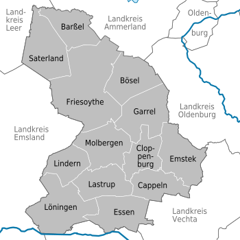
Communities
(Residents on December 31, 2019)
|
  |
Protected areas
In addition to landscape protection areas and natural monuments, there are 22 designated nature reserves in the district (as of February 2017).
See also:
- List of nature reserves in the district of Cloppenburg
- List of landscape protection areas in the district of Cloppenburg
- List of natural monuments in the district of Cloppenburg
- List of protected landscape components in the district of Cloppenburg
License Plate
On July 1, 1956, the district was assigned the CLP distinctive sign when the vehicle registration number that is still valid today was introduced . It is still issued today.
Others

In Saterland a living language minority who Sater . They form the smallest language island in Europe.
The district of Cloppenburg has the highest birth rate in all of Germany. With a fertility rate of 1.92 children per woman, the district is well above the national German average of 1.37. The reasons given for this are the classic distribution of roles between men and women in the conservative region and the comparatively high number of Russian-German resettlers in the area, who tend to have a higher birth rate.
Personalities
- Hermann Bitter (born September 26, 1897 in Ramsloh; † November 21, 1982 ibid), District Administrator 1946–1964
literature
- J. Hoffmeister: 1930: The climate of Lower Saxony. Hanover . Publications of the economic society for the study of Lower Saxony. Row B, Book 6.
- J. Hoffmeister: 1937: The climate circles of Lower Saxony. Oldenburg i. O . Publications of the Economic Society for the Study of Lower Saxony Series B, Issue 16.
Web links
- Portal: Oldenburger Münsterland
- Literature from and about the district of Cloppenburg in the catalog of the German National Library
Individual evidence
- ↑ State Office for Statistics Lower Saxony, LSN-Online regional database, Table 12411: Update of the population, as of December 31, 2019 ( help ).
- ↑ Oldenburg law for the simplification and cheaper administration of April 27, 1933
- ↑ a b c d e Michael Rademacher: German administrative history. (No longer available online.) Archived from the original on April 2, 2016 ; accessed on January 2, 2015 . Info: The archive link was inserted automatically and has not yet been checked. Please check the original and archive link according to the instructions and then remove this notice.
- ^ Law on the formation of new communities in the Lower Saxony administrative district of Oldenburg of April 26, 1948
- ^ Law on the reorganization of the municipalities in the Vechta / Cloppenburg area of February 11, 1974
- ↑ Statistical Yearbook for the Federal Republic of Germany 1972
- ↑ Statistical Yearbook for the Federal Republic of Germany 1981
- ↑ a b c d Lower Saxony regional database
- ↑ Deutschlandradio: Russians on the flat country
- ↑ Broken Catholic dominance in the circle
- ^ District of Cloppenburg Religion , 2011 census
- ↑ Overview: The results of the direct elections in Lower Saxony ( Memento of the original from December 24, 2014 in the Internet Archive ) Info: The archive link was automatically inserted and not yet checked. Please check the original and archive link according to the instructions and then remove this notice. , accessed November 4, 2014
- ↑ Manfred Furchert: Oldenburgisches crests. Volume 1. Oldenburg 2003, p. 35
- ^ Johannes Wilking, Manfred Kayser: Biogas production in the Oldenburger Münsterland - developments and perspectives. In: Yearbook for the Oldenburger Münsterland 2011. Vechta 2010, p. 211
- ↑ Future Atlas 2016. (No longer available online.) Archived from the original on October 2, 2017 ; accessed on March 23, 2018 . Info: The archive link was inserted automatically and has not yet been checked. Please check the original and archive link according to the instructions and then remove this notice.
- ↑ State Office for Statistics Lower Saxony, LSN-Online regional database, Table 12411: Update of the population, as of December 31, 2019 ( help ).
- ↑ Deutschlandradio: Russians on the flat country
Counties : Ammerland | Aurich | Celle | Cloppenburg | Cuxhaven | Diepholz | Emsland | Friesland | Gifhorn | Goslar | Göttingen | County of Bentheim | Hameln-Pyrmont | Harburg | Heidekreis | Helmstedt | Hildesheim | Holzminden | Empty | Lüchow-Dannenberg | Lüneburg | Nienburg / Weser | Northeim | Oldenburg | Osnabrück | Osterholz | Peine | Rotenburg (Wümme) | Schaumburg | Stade | Uelzen | Vechta | Verden | Wesermarsch | Wittmund | Wolfenbüttel
Region : Hanover
Independent cities : Braunschweig | Delmenhorst | Emden | Oldenburg (Oldb) | Osnabrück | Salzgitter | Wilhelmshaven | Wolfsburg