
Lachaussée
| Lachaussée | ||
|---|---|---|

|
|
|
| region | Grand Est | |
| Department | Meuse | |
| Arrondissement | Commercy | |
| Canton | Saint-Mihiel | |
| Community association | Côtes de Meuse Woëvre | |
| Coordinates | 49 ° 2 ' N , 5 ° 49' E | |
| height | 203-238 m | |
| surface | 27.19 km 2 | |
| Residents | 271 (January 1, 2017) | |
| Population density | 10 inhabitants / km 2 | |
| Post Code | 55210 | |
| INSEE code | 55267 | |

Lachaussée is a French commune with 271 inhabitants (as of January 1, 2017) in the Meuse department in the Grand Est region (until 2015 Lorraine ).
geography
Lachaussée is located on the Étang de Lachaussée , about 30 kilometers southwest of Metz and 35 kilometers southeast of Verdun . The municipality is part of the Lorraine Regional Nature Park .
Population development
| year | 1962 | 1968 | 1975 | 1982 | 1990 | 1999 | 2007 | 2014 |
| Residents | 137 | 117 | 170 | 161 | 219 | 256 | 244 | 270 |
Attractions
- Saint-Nicolas church
- Sainte-Anne church in the Haumont-lès-Lachaussée district
- Saint-Léger church in the Hadonville-lès-Lachaussée district
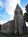
Saint-Nicolas church
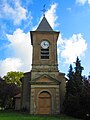
Sainte-Anne church in Haumont-lès-Lachaussée

Saint-Léger church in Hadonville-lès-Lachaussée


literature
- Le Patrimoine des Communes de la Meuse. Flohic Editions, Volume 2, Paris 1999, ISBN 2-84234-074-4 , pp. 1167-1173.
Web links
Commons : Lachaussée - collection of images, videos and audio files
- Community presentation (French)