
Paderborn district (1816–1974)
| coat of arms | Germany map |
|---|---|

|

Coordinates: 52 ° 17 ' N , 8 ° 55' E |
| Basic data (as of 1974) | |
| Existing period: | 1816-1974 |
| State : | North Rhine-Westphalia |
| Administrative region : | Detmold |
| Regional association : | Westphalia-Lippe |
| Administrative headquarters : | Paderborn |
| Area : | 553.67 km 2 |
| Residents: | 153,400 (Dec. 31, 1973) |
| Population density : | 277 inhabitants per km 2 |
| License plate : | PB |
| Circle key : | 05 7 40 |
| Circle structure: | 18 parishes |
| Address of the district administration: |
Aldegreverstrasse 10-14 4790 Paderborn |
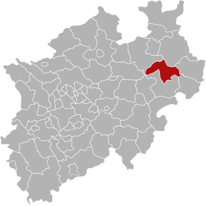
| Location of the Paderborn district in North Rhine-Westphalia | |
  |
|

The district Paderborn (1939-1969: District Paderborn ) was from 1816 to 1974 existing circle . The district was initially part of the administrative district of Minden in the Prussian province of Westphalia , from 1946/47 part of the North Rhine-Westphalian administrative district of Detmold . The administrative seat was Paderborn . The district went up in 1975 as part of the North Rhine-Westphalian regional reform together with the Büren district in the newly founded Paderborn district .
geography
location
The old district of Paderborn was between 51 ° 56 'and 51 ° 37' N.B. and between 8 ° 24 'and 9 ° 00' E. L. in the southeast corner of the Westphalian Bay . It played a part in the eastern Hellweg area , extended far into the Senne in the north , was bordered by the Egge Mountains in the east , and the Paderborn plateau in the south .
The Ems has its source here in the Senne between Stukenbrock and Hövelhof . The Lippe rises in Bad Lippspringe and the Pader and Alme flow into it in Neuhaus Castle . Below Kirchborchen the Altenau flows into the Alme.
expansion
In 1950 the district covered an area of 596.57 km² with a resident population of 109,045 inhabitants. So he had a population density of 183 inhabitants per km².
At the point where the district bordered the districts of Wiedenbrück and Lemgo, the district of Bielefeld also bordered. This point in the middle of the formerly deserted Senne used to be a quadrangle, which is still reminiscent of historical landmarks today: This is where the territories of the County of Ravensberg , the County (later Principality) of Lippe , the Hochstift Paderborn and the County of Rietberg met .
Neighboring areas
In 1969, the Paderborn district bordered clockwise to the north, starting with the Bielefeld , Lemgo , Detmold , Höxter , Warburg , Büren , Lippstadt and Wiedenbrück districts .
The district boundary was 167 km long. Starting in the north, clockwise, the borders with the districts of Lemgo were 6 km, Detmold 25 km, Höxter 19 km, Warburg 5 km, Büren 79 km, and Wiedenbrück 33 km (status at the end of 1971).
history
After the prince-bishopric of Paderborn fell to Prussia in 1803 due to the Reichsdeputationshauptschluss , the prince-bishopric became the principality of Paderborn . The Prussian authorities divided its area into three new districts , the Oberwald district in the east, the Warburg district in the south and the Unterwald district in the west of the principality. The Oberamt Neuhaus and the offices of Delbrück, Boke , Büren and Wewelsburg belonged to the Unterwaldische Kreis . Maximilian von Elverfeldt was appointed as the district administrator .
From 1807 to 1813 the area belonged to the Kingdom of Westphalia and received an administrative structure based on the French model. The later district area now belonged to the Paderborn district in the Fulda department and was divided into the five cantons of Paderborn, Delbrück, Lippspringe, Neuhaus and Paderborn. The former district administrator Maximilian von Elverfeldt was sub-prefect of the Paderborn district during this time .
After the collapse of French rule, the area fell back to Prussia in 1813, which, after confirmation by the Congress of Vienna in 1815 , incorporated its acquisition into its newly created province of Westphalia . In the newly established administrative district of Minden , the Paderborn district was formed on October 18, 1816 by ordinance of the Royal Government in Minden . The cantons founded in 1807 initially existed as administrative districts, sometimes also referred to as “ mayor's offices ”. In 1832 Oberntudorf and Niederntudorf were reclassified from the Paderborn district to the Büren district .
As part of the introduction of the rural community order for the province of Westphalia, the district was divided into the four offices of Delbrück , Lippspringe , Kirchborchen and Neuhaus in 1844. The city of Paderborn remained vacant.
On March 10, 1880, the Kirchborchen office moved into a newly constructed building in Nordborchen on today's Paderborner Strasse. Shortly before, the office had bought the property for this purpose from Baron von Brenken. This building, which was expanded in 1905, served the office as an administrative office until its dissolution at the end of 1974, after which the Borchen community served as the municipal administration until the new town hall in Kirchborchen was built in 1984.
In 1895 Hövelhof and Stukenbrock moved from the Delbrück office to the Neuhaus office. In 1921 Lippspringe became vacant. The Lippspringe office was initially named "Lippspringe Office with its seat in Altenbeken" and later the name "Altenbeken Office". The municipality Neuhaus received after the celebration of the 700th anniversary in November 1957 the additional name "Castle". The village farming community was incorporated into Delbrück in 1964 .
1969 Stukenbrock with communities Schloss Holte and broadcast from the Office Verl , Kreis Wiedenbrück , the new municipality (city since 2003) Schloss Holte-Stukenbrock together and came to a temporary circle Bielefeld , from 1973 to Gütersloh . Also in 1969 Marienloh from the Altenbeken office and Wewer from the Kirchborchen office were incorporated into Paderborn, while Alfen , Kirchborchen and Nordborchen merged to form the Borchen municipality with its headquarters in Nordborchen. The community of Sande joined the community of Neuhaus Castle .
On October 1, 1969, the district became the Paderborn district.
On January 1, 1975, the Sauerland / Paderborn law came into force, as a result of which the Paderborn district was merged with almost the entire area of the Büren district to form the new Paderborn district. After Paderborn, Benhausen , Marienloh and Neuenbeken were incorporated from the Altenbeken office, Dahl from the Kirchborchen office and Elsen and Schloss Neuhaus from the Neuhaus office. Altenbeken, Buke and Schwaney merged to form the new large municipality of Altenbeken . The community Hövelhof from the Neuhaus district was expanded to include the Espeln district of the Ostenland community from the Delbrück district. The municipalities of the Delbrück office and the three Lippe municipalities Anreppen , Bentfeld and Boke from the Salzkotten-Boke office of the Büren district merged to form the city of Delbrück . The municipality of Borchen, which was newly formed in 1969, was expanded to include Dörenhagen from the Kirchborchen office and Etteln from the Atteln office in the Büren district. At the same time, all offices were dissolved.
Population development
| year | Residents | source |
|---|---|---|
| 1821 | 27,082 | |
| 1832 | 29,065 | |
| 1843 | 33,816 | |
| 1864 | 38,692 | |
| 1871 | 40,362 | |
| 1880 | 42,899 | |
| 1890 | 46,400 | |
| 1900 | 53,511 | |
| 1910 | 64,629 | |
| 1925 | 73,587 | |
| 1939 | 86,914 | |
| 1946 | 94.364 | |
| 1950 | 109.045 | |
| 1960 | 121,800 | |
| 1970 | 140,500 | |
| 1973 | 153,400 |
politics
Results of the district elections from 1946 to 1970
The list only shows parties and constituencies that received at least two percent of the votes in the respective election.
Share of votes of the parties in percent
| year | CDU | SPD | FDP | DZP |
|---|---|---|---|---|
| 1946 1 | 56.7 | 15.7 | 25.2 | |
| 1948 | 46.0 | 19.7 | 4.3 | 28.6 |
| 1952 | 42.6 | 19.0 | 10.4 | 25.0 |
| 1956 | 50.1 | 22.2 | 9.0 | 18.4 |
| 1961 | 66.1 | 20.8 | 6.8 | 6.3 |
| 1964 2 | 62.0 | 25.1 | 7.4 | |
| 1970 |
Footnotes
1 1946: additionally: KPD: 2.3%
2 1964: additionally: UWG: 5.5%
District administrators
- 1817–1831: Maximilian von Elverfeldt
- 1831–1834: Adolph von Spiegel-Borlinghausen
- 1834–1842: Klemens von Wolff-Metternich
- 1842–1870: Franz Ludwig Grasso
- 1870–1875: Hugo von Brackel
- 1875–1903: Walther Jentzsch
- 1903–1934: Friedrich von Laer
- 1934–1937: Friedrich Homann
- 1937–1945: Heinrich Althans
- 1946 : Ferdinand Henkemeyer ( center )
- 1946–1948: Josef Büssemeier ( CDU )
- 1948–1963: Karl Rennkamp (CDU)
- 1963–1964: Johannes Ising (CDU)
- 1964–1974: Joseph Köhler (CDU)
coat of arms
 |
The head of the shield symbolizes the affiliation to the former Paderborn Monastery , the two wavy bars the Pader and Alme rivers . The coat of arms was approved on June 30, 1947. |
Municipalities of the Paderborn district
According to offices (area and resident population as of 1950, administrative seat *):
Official:
- Bad Lippspringe , city: 50.57 km², 8,253 E
- Paderborn , city: 44.24 km², 40,270 E
Altenbeken office : 108.26 km², 9,335 E
- Altenbeken *: 25.93 km², 3,610 E
- Benhausen : 9.80 km², 1,049 E
- Buke : 16.73 km², 886 E.
- Marienloh : 7.38 km², 854 E
- Neuenbeken : 17.48 km², 1,426 E
- Schwaney : 30.94 km², 1,510 E.
Office Delbrück : 138.75 km², 14,974 E
- Delbrück *, city: 4.85 km², 2,365 E
- Village farmers : 15.77 km², 2,302 E
- Hagen : 18.47 km², 1,493 E.
- Ostenland : 37.48 km², 3,744 E.
- Westenholz : 37.75 km², 2,451 E
- Westerloh : 30.43 km², 2,691 E
Office Kirchborchen : 87.48 km², 8,980 E
- Alfen : 7.92 km², 1,062 E
- Dahl : 17.10 km², 979 E
- Dörenhagen : 15.95 km², 1,024 E
- Kirchborchen : 20.89 km², 2,203 E
- Nordborchen *: 9.28 km², 1,447 E
- Wewer : 16.34 km², 2,265 E
Amt Neuhaus : 167.01 km², 27,223 E
- Neuhaus *: 26.35 km², 10,107 E
- Elsen : 20.08 km², 4,825 E.
- Hövelhof : 55.50 km², 5,584 E
- Sands : 22.41 km², 2,147 E
- Stukenbrock : 42.67 km², 4,560 E
License Plate
On July 1, 1956, when the vehicle registration number was introduced, the district at that time was assigned the distinguishing mark PB .
Individual evidence
- ↑ Thomas Reich: Erbfürstentum Paderborn, circles. Finding aid G111. Landesarchiv NRW Westphalia department, 2013, accessed on November 1, 2017 .
- ↑ Theodor Kraayvanger: The organization of the Prussian judiciary and administration in the Principality of Paderborn . In: Münster contributions to historical research . Schöningh, Paderborn 1905, chap. The appointment of the district administrators , p. 44-48 . ( Digitized version ).
- ^ Regional Association Westphalia-Lippe (ed.); Project Westphalian History: Royal Decree, which ordered the division of the kingdom into eight departments , p. 107.
- ↑ a b Westfalenlexikon 1832–1835 . In: Landschaftsverband Westfalen-Lippe (Ed.): Reprints for the Westphalian archive maintenance . tape 3 . Münster 1978, p. 178 (reprint of the original from 1834).
- ^ Official Journal of the Minden Government 1831: Change in the regional division of Westphalia
- ↑ Landgemeinde -ordnung for the Province of Westphalia from October 31, 1841 (PDF; 1.6 MB)
- ^ Official Journal of the Minden Government 1844. Retrieved February 2, 2014 .
- ^ Wolfgang Leesch: Administration in Westphalia 1815-1945 . In: Publications of the Historical Commission for Westphalia . tape 38 . Aschendorff, Münster 1992, ISBN 3-402-06845-1 .
- ↑ Announcement of the new version of the district regulations for the state of North Rhine-Westphalia from August 11, 1969 in the Law and Ordinance Gazette for the state of North Rhine-Westphalia, year 1969, No. 2021, p. 670 ff.
- ^ Federal Statistical Office (ed.): Historical municipality directory for the Federal Republic of Germany. Name, border and key number changes in municipalities, counties and administrative districts from May 27, 1970 to December 31, 1982 . W. Kohlhammer, Stuttgart / Mainz 1983, ISBN 3-17-003263-1 , p. 327 f .
- ↑ Statistical-topographical overview of the government district of Minden 1821. In: Digital Collections ULB Münster. Retrieved March 3, 2014 .
- ↑ Seemann: Geographical-statistical-topographical overview of the administrative district of Minden. (pdf) 1843, p. 13 , accessed on January 12, 2015 .
- ↑ Topographical-statistical manual of the government district of Minden. (Digitized version) 1866, p. 5 , accessed on January 12, 2015 .
- ↑ a b Community encyclopedia Westphalia 1887 p. 127
- ↑ a b c d e f g Michael Rademacher: German administrative history from the unification of the empire in 1871 to the reunification in 1990. paderborn.html. (Online material for the dissertation, Osnabrück 2006).
- ↑ 1946 census
- ↑ Statistical Yearbook for the Federal Republic of Germany 1972
- ↑ Statistical Yearbook for the Federal Republic of Germany 1975
- ↑ Source: respective issue of the State Statistical Office (LDS NRW), Mauerstr. 51, Düsseldorf, with the election results at the district level. The 1970 figures are not available.
literature
- Günter von Geldern-Crispendorf: District of Paderborn. Administrative district Detmold (= The administrative districts in North Rhine-Westphalia. Series B: Westphalia, Volume 1). Böhlau Verlag Münster / Cologne, Verlag Aschendorf Münster (Westphalia) 1953.
- Paul Graebner: Paderborn district (= Nature Conservation Guide of the Westphalian Heimatbund , issue 1). Munster 1960.
- Paul Pagendarm: The Paderborn district (= district and city handbooks of the Westphalian Heimatbund , Volume 15). Munster 1951.
Web links
- District of Paderborn administrative history and the district administrators on the website territorial.de (Rolf Jehke), as of November 26, 2013.

Before the founding of North Rhine-Westphalia in what is now North Rhine-Westphalia, the (rural) districts: Bilstein | Blankenheim | Bochum | Brakel | Frets | Dortmund | Duisburg | Düsseldorf | Elberfeld | Eslohe | Food | Geilenkirchen | Gelsenkirchen | Gemünd | Gimborn | Gladbach | Grevenbroich-Neuss | Gummersbach | Hagen | Hamm | Hattingen | Heinsberg (1816-1932) | Homburg | Hörde | Kempen | Krefeld | Lechenich | Lennep | Medebach | Mettmann | Mülheim am Rhein | Mülheim an der Ruhr | Neuss | Opladen | Rahden | Rheinbach | Rheinberg | Ruhrort | Schwelm | Solingen | Solingen-Lennep | Uckerath | Waldbröl | Wipperfürth
Former North Rhine-Westphalian (rural) districts: Aachen (1816–1971) | Aachen (1972–2009) | Ahaus | Altena | Arnsberg | Beckum | Bergheim (Erft) | Bielefeld | Bonn | Borken (1816–1974) | Brilon | Büren | Coesfeld (1816–1974) | Detmold | Dinslaken | Düren (1816–1971) | Düsseldorf-Mettmann | Erkelenz | Geilenkirchen-Heinsberg | Geldern | Grevenbroich | Halle (Westphalia) | Höxter (1816–1974) | Iserlohn | Jülich | Kempen-Krefeld | Cologne | Lemgo | Lippstadt | Lübbecke | Lüdenscheid | Lüdinghausen | Meschede | Minden | Moers | Monschau | Munster | Paderborn (1816–1974) | Rees | Rhein-Wupper-Kreis | Schleiden | Selfkantkreis Geilenkirchen-Heinsberg | Victories | Siegkreis | Soest (1817–1974) | Steinfurt (1816–1974) | Tecklenburg | Unna (1930–1974) | Warburg | Warendorf (1816–1974) | Wiedenbrück | Wittgenstein

Districts: Ahaus | Altena | Arnsberg | Beckum | Bielefeld | Bilstein | Bochum | Bark | Brakel | Brilon | Frets | Büren | Coesfeld | Dortmund | Ennepe-Ruhr district | Eslohe | Gelsenkirchen | Hagen | Halle (Westphalia) | Hamm | Hattingen | Herford | Hörde | Höxter | Iserlohn | Lippstadt | Lübbecke | Lüdinghausen | Medebach | Meschede | Minden | Munster | Olpe | Paderborn | Rahden | Recklinghausen | Schwelm | Victories | Soest | Steinfurt | Tecklenburg | Unna | Warburg | Warendorf | Wiedenbrück | Wittgenstein
City districts: Bielefeld | Bocholt | Bochum | Bottrop | Buer | Castrop-Rauxel | Dortmund | Gelsenkirchen | Gelsenkirchen-Buer | Gladbeck | Hagen | Hamm | Herford | Herne | Hörde | Iserlohn | Lüdenscheid | Lünen | Minden | Munster | Osterfeld | Recklinghausen | Victories | Wanne-Eickel | Wattenscheid | Witten
Alfen | Altenbeken | Bad Lippspringe | Benhausen | Buke | Dahl | Delbrück | Doerenhagen | Elsen | Hagen | Hövelhof | Kirchborchen | Marienloh | Neuenbeken | Nordborchen | Ostenland | Paderborn | Sands | Neuhaus Castle | Schwaney | Stukenbrock | Westenholz | Westerloh | Wewer