
Monfort
| Monfort | ||
|---|---|---|
.svg)
|
|
|
| region | Occitania | |
| Department | Gers | |
| Arrondissement | Condom | |
| Canton | Gimone Arrats | |
| Community association | Communauté de communes Bastides de Lomagne | |
| Coordinates | 43 ° 48 ' N , 0 ° 49' E | |
| height | 105-194 m | |
| surface | 22.49 km 2 | |
| Residents | 492 (January 1, 2017) | |
| Population density | 22 inhabitants / km 2 | |
| Post Code | 32120 | |
| INSEE code | 32269 | |
 Monfort |
||

Monfort is a French commune with 492 inhabitants (as of January 1, 2017) in the Gers department in the Occitanie region . It belongs to the Arrondissement Condom and the Canton of Gimone-Arrats .
Neighboring municipalities are Cadeilhan (point of contact), Bivès in the north, Homps in the northeast, Solomiac in the east, Labrihe and Mauvezin in the southeast, Sérempuy in the south, Sainte-Gemme in the southwest and Saint-Brès and Bajonnette in the west.
Population development
| year | 1962 | 1968 | 1975 | 1982 | 1990 | 1999 | 2008 | 2015 |
|---|---|---|---|---|---|---|---|---|
| Residents | 644 | 539 | 495 | 454 | 614 | 424 | 479 | 488 |
Attractions
- Esclignac Castle
- Saint Blaise Chapel
- Saint-Clément church, historic monument since 1964
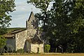
Saint Blaise Chapel on the Mauvezin road
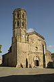
Saint-Clément church

Vegetable market in Monfort, always in autumn
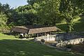
Former wash house


Web links
Commons : Monfort (Gers) - Collection of images, videos and audio files