
Ligardes
|
Ligardes Ligardas |
||
|---|---|---|
|
||
| region | Occitania | |
| Department | Gers | |
| Arrondissement | Condom | |
| Canton | Lectoure-Lomagne | |
| Community association | Communauté de communes de la Ténarèze | |
| Coordinates | 44 ° 2 ′ N , 0 ° 29 ′ E | |
| height | 77-182 m | |
| surface | 11.30 km 2 | |
| Residents | 217 (January 1, 2017) | |
| Population density | 19 inhabitants / km 2 | |
| Post Code | 32480 | |
| INSEE code | 32212 | |

Ligardes ( Gascon : Ligardas) is a French municipality with 217 inhabitants (at January 1, 2017) in the department of Gers in the region Occitania (2015 Midi-Pyrénées ); it belongs to the Arrondissement Condom and the municipality of Ténarèze . The residents call themselves Ligardais / Ligardaises .
geography
Ligardes is located around 13 kilometers northeast of Condom and 21 kilometers southwest of Agen in the very north of the Gers department on the border with the Lot-et-Garonne department . The community consists of hamlets, numerous scattered settlements and individual farmsteads. In parts, the river Auvignon forms the western and the river Petit Auvignon the eastern municipal boundary .
Neighboring municipalities are Nomdieu (in the Lot-et-Garonne department) in the north, Lamontjoie (in the Lot-et-Garonne department) in the northeast, Pouy-Roquelaure in the east, Gazaupouy in the south and southwest, Moncrabeau (in the Lot-et-Garonne department) in the west and Francescas (in the Lot-et-Garonne department) in the north-west.
history
Finds from the Gallo-Roman period prove an early settlement. Before 1789 the municipality belonged to the Condomois county within Gascony . Ligardes belonged to the Lectoure district and the canton of Saint-Mézard from 1793 to 1801. From 1801 to 1926 the parish was assigned to the Lectoure arrondissement. Since then it has belonged to the Condom arrondissement. Ligardes belonged to the canton of Lectoure from 1793 to 1984 and to the canton of Condom from 1984 to 2015 .
Population development
The community shows a development typical of French rural communities with a strong loss of population since the early 19th century. The population grew rapidly between 1800 and 1831. This was followed by a period of strong population fluctuations with several waves of emigration and growth phases. Today the population has reached its historic low (1831–2016: −68.3 percent).
| year | 1793 | 1800 | 1831 | 1876 | 1896 | 1962 | 1968 | 1975 | 1982 | 1990 | 1999 | 2006 | 2011 | 2016 |
| Residents | 620 | 489 | 688 | 608 | 427 | 303 | 280 | 247 | 261 | 269 | 250 | 239 | 222 | 218 |
| Sources: Cassini and INSEE | ||||||||||||||
Attractions
- Château de Campaigno castle ; Monument historique since 2013
- Church Saint-Hilaire from the 14th century
- Center with old houses
- Castle chapel
- several wayside crosses
- Memorial to the Fallen

Mairie (Town Hall) of the parish
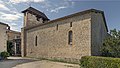
Fortified Church of Saint-Hilaire

City gate

Memorial to the Fallen

Landscape near Ligardes


Web links
- Ligardes on the IGN website
- Saint-Hilaire church and chapel
- Location of the place and brief information
- The municipality on the side of the municipal association
- Sights of Ligardes on Le Patrimoine rural du Gers