Thoux
|
Thoux Tors |
||
|---|---|---|
|
|
||
| region | Occitania | |
| Department | Gers | |
| Arrondissement | Condom | |
| Canton | Gimone Arrats | |
| Community association | Bastides de Lomagne | |
| Coordinates | 43 ° 41 ′ N , 1 ° 0 ′ E | |
| height | 147-214 m | |
| surface | 6.12 km 2 | |
| Residents | 253 (January 1, 2017) | |
| Population density | 41 inhabitants / km 2 | |
| Post Code | 32430 | |
| INSEE code | 32444 | |
Thoux ( Occitan : Tors ) is a French commune with 253 inhabitants (as of January 1, 2017) in the Gers department in the Occitanie region (until 2015 Midi-Pyrénées ). It belongs to the Arrondissement Condom and the municipal association Bastides de Lomagne, founded in 2012 . The inhabitants call themselves Thouxéens .
geography
Thoux is located in the south of Lomagne , 35 kilometers east of Auch and about 37 kilometers west of Toulouse . In the west, the Sarrampion river forms the municipal boundary ; in the northeast, the municipality has a share of the Lac de Thoux-Saint-Cricq reservoir . The almost forest-free 6.12 km² extensive municipal area is characterized by fields and pastures. The height differences are minimal: the village of Thoux is 200 m above sea level; in the extreme south-east of the municipality, 214 m above sea level are reached. The largest of the numerous hamlets are Cederès, En Capulet and La Teulère . Thoux is bordered by the neighboring communities of Saint-Cricq in the north, Encausse in the east, Monbrun in the southeast, Roquelaure-Saint-Aubin in the southwest, Saint-Germier in the west and Sirac in the northwest.
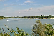
Lac de Thoux-Saint-Circq
The Lac de Thoux-Saint-Circq reservoir extends over the territory of the four municipalities of Monbrun, Encausse, Thoux and Saint-Cricq. It was built for flood protection, but mainly for irrigation of the fields (corn, soybeans, etc.). Only later did the lake develop into a local recreation area, which is mainly used by the big city dwellers of the metropolis of Toulouse, only 37 kilometers away. The lake was dammed for the first time in 1968. When fully blocked, the water volume is 3.5 million cubic meters over an area of 70 hectares. The lake level is 169 m above sea level; the earth dam is 15.5 m high. In order to keep the water level more or less constant, water is pumped from the Sava near L'Isle-Jourdain through a pipeline several kilometers long into a tributary of the reservoir. The owner and operator of the reservoir is the Compagnie d'aménagement des coteaux de Gascogne (CACG).
The lake is popular for fishing (for pikeperch, pike, carp). A tourist infrastructure has been developed on the shores of the lake in the municipality of Thoux: there is a water sports base, a campsite, a leisure center, a water park, a sailing club, rental stations for pedal boats and canoes and dining facilities.
Population development
| year | 1962 | 1968 | 1975 | 1982 | 1990 | 1999 | 2006 | 2017 |
|---|---|---|---|---|---|---|---|---|
| Residents | 150 | 99 | 118 | 109 | 136 | 163 | 182 | 253 |
| Sources: Cassini and INSEE | ||||||||
Attractions
- Saint Martin Church
- several hall crosses
- Water Park
Economy and Infrastructure
In addition to tourism, agriculture also plays an important role in Thoux. There are 17 farms in the municipality (mainly cereal and vegetable growing).
The D 654 trunk road from Mauvezin to L'Isle-Jourdain runs through the municipality of Thoux . In L'Isle-Jourdain, eleven kilometers away, there is a connection to the motorway-like RN 124 . There is also a train station on the route from Saint-Agne to Auch .
supporting documents
- ↑ Technical data on annuaire-mairie.fr (French)
- ↑ Reservoir on saint.cricq.free.fr (French)
- ↑ Thoux on cassini.ehess.fr (French)
- ↑ Thoux on INSEE
- ↑ Farms on annuaire-mairie.fr (French)

