Labrihe
| Labrihe | ||
|---|---|---|
|
|
||
| region | Occitania | |
| Department | Gers | |
| Arrondissement | Condom | |
| Canton | Gimone Arrats | |
| Community association | Bastides de Lomagne | |
| Coordinates | 43 ° 46 ' N , 0 ° 53' E | |
| height | 115-184 m | |
| surface | 9.44 km 2 | |
| Residents | 209 (January 1, 2017) | |
| Population density | 22 inhabitants / km 2 | |
| Post Code | 32120 | |
| INSEE code | 32173 | |
| Website | Labrihe | |
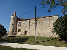
 Mayor's office ( Mairie ) of Labrihe |
||
Labrihe is a French commune with 209 inhabitants (as of January 1, 2017) in the Gers department in the Occitanie region (before 2016: Midi-Pyrénées ). The municipality belongs to the Arrondissement Condom (until 2016: Arrondissement Auch ) and the canton Gimone-Arrats (until 2015: Canton Mauvezin ).
The inhabitants are called Labrigeois and Labrigeoises .
geography
Labrihe is about 27 kilometers northeast of Auch in the historic province of Armagnac on the eastern edge of the department.
Labrihe is surrounded by the five neighboring communities:
| Monfort | Solomiac | |

|
Sarrant | |
| Mauvezin | Saint-Georges |
Waters
Labrihe lies in the catchment area of the Garonne River .
The Arrats , one of its left tributaries, crosses the western municipality from south to north. The Ruisseau de la Barage flows into the Arrats at Labrihe as a left tributary. The Gimone , another left tributary of the Garonne, forms the natural border with the neighboring municipalities of Sarrant and Saint-Georges to the east.
history
Labrihe is mentioned in the copy book of the Gimont monastery , whose monks founded the Franqueville barn in 1151.
In 1822 the former municipality of Bouvées was incorporated.
Population development
With the incorporation of Bouvées, the number of inhabitants rose to a high of around 515. In the following period, the size of the community fell with interim recovery phases until the 1990s to its lowest level of around 135 inhabitants, before a phase of growth began that continues today.
| year | 1962 | 1968 | 1975 | 1982 | 1990 | 1999 | 2006 | 2011 | 2017 |
|---|---|---|---|---|---|---|---|---|---|
| Residents | 181 | 152 | 142 | 145 | 136 | 150 | 187 | 203 | 209 |
Attractions
Bouvées Castle
It was built from 1530 to 1560 by Monseigneur de Saint-Julien, Bishop of Aire-sur-Adour , on the ruins of an earlier building. The building was sold as a national good during the French Revolution . It consisted of three wings that delimited an inner courtyard and were flanked at the corners by round towers. Only the eastern and southern wings are preserved, as are the agricultural stables, which are secured by the old walls and reflect the original arrangement. Of the towers, only the south-east and traces of the south-west remain. The dovecote was built on the foundations of a tower. A section of the ruined wall near the apse of the side chapels indicates the old gate that gave access to the inner courtyard. A round tower with four levels is attached to the chapel. A vaulted cellar in the basement made it possible to monitor the area through a series of observation holes. Inside the castle there are chimneys from the 15th and 18th centuries, terracotta paving , beamed ceilings and exposed beams. Facades and roofs, round walls, places of the former moat, the chapel, the two round towers, the two spiral staircases and the dovecote have been classified as Monument historique since October 11, 1990 .
Labrihe Castle
Like the castle of Bouvées, it was built by Monseigneur de Saint-Julien at the end of the 16th century on the ruins of a previous building. The land of Labrihe was sold by the Preissac family to Melchior François Reversac de Celez in the 18th century and then passed to the Saint-Blanquat family. Today the castle is privately owned.
More Attractions
- Saint-Pierre church
- Sainte-Radegonde church in Bouvées
Economy and Infrastructure
Labrihe is located in the AOC zone of the Ail violet de Cadours garlic variety .

total = 27
traffic
Labrihe can be reached via Routes départementales 40, 654, the former Route nationale 654 , and 928, the former Route nationale 128 .
Web links
Individual evidence
- ↑ Gers ( fr ) habitants.fr. Retrieved December 28, 2019.
- ↑ Ma commune: Labrihe ( fr ) Système d'Information sur l'Eau du Bassin Adour Garonne. Retrieved December 28, 2019.
- ↑ a b Château de Labrihe ( fr ) chateau-fort-manoir-chateau.eu. Retrieved December 28, 2019.
- ↑ a b Notice Communale Labrihe ( fr ) EHESS . Retrieved December 28, 2019.
- ↑ Populations légales 2016 Commune de Labrihe (32173) ( fr ) INSEE . Retrieved December 28, 2019.
- ↑ Château de Bouvées ( fr ) French Ministry of Culture . May 15, 2019. Retrieved December 28, 2019.
- ↑ Institut national de l'origine et de la qualité: Rechercher un produit ( fr ) Institut national de l'origine et de la qualité . Retrieved December 28, 2019.
- ↑ Caractéristiques des établissements en 2015 Commune de Labrihe (32173) ( fr ) INSEE . Retrieved December 28, 2019.


