Lamothe-Goas
|
Lamothe-Goas La Mòta Gohàs |
||
|---|---|---|

|
|
|
| region | Occitania | |
| Department | Gers | |
| Arrondissement | Condom | |
| Canton | Fleurance-Lomagne | |
| Community association | Communauté de communes de la Lomagne Gersoise | |
| Coordinates | 43 ° 52 ' N , 0 ° 34' E | |
| height | 87-155 m | |
| surface | 7.18 km 2 | |
| Residents | 78 (January 1, 2017) | |
| Population density | 11 inhabitants / km 2 | |
| Post Code | 32500 | |
| INSEE code | 32188 | |
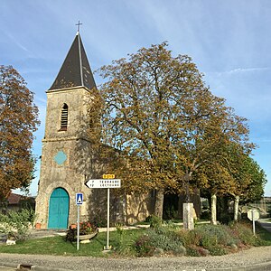
 Saint-Charles-Borromée church |
||
Lamothe-Goas ( Gascon : La Mota Gohàs) is a French municipality with 78 inhabitants (at January 1, 2017) in the department of Gers in the region Occitania (2015 Midi-Pyrénées ); it belongs to the Arrondissement Condom and the municipality of Ténarèze . The residents call themselves Lamothois / Lamothoises .
It is surrounded by the neighboring communities of Terraub in the north, Pauilhac in the east, Sainte-Radegonde in the southeast, La Sauvetat in the south, southwest and Mas-d'Auvignon in the northwest.
Population development
| year | 1793 | 1821 | 1962 | 1968 | 1975 | 1982 | 1990 | 1999 | 2006 | 2011 | 2016 |
| Residents | 220 | 315 | 84 | 73 | 75 | 70 | 73 | 64 | 59 | 66 | 77 |
| Sources: Cassini and INSEE | |||||||||||
Web links
Commons : Lamothe-Goas - Collection of images, videos and audio files
