Fleurance
| Fleurance | ||
|---|---|---|

|
|
|
| region | Occitania | |
| Department | Gers | |
| Arrondissement | Condom | |
| Canton | Fleurance-Lomagne (main town) | |
| Community association | Lomagne Gersoise | |
| Coordinates | 43 ° 51 ′ N , 0 ° 40 ′ E | |
| height | 83-181 m | |
| surface | 43.32 km 2 | |
| Residents | 6,021 (January 1, 2017) | |
| Population density | 139 inhabitants / km 2 | |
| Post Code | 32500 | |
| INSEE code | 32132 | |
| Website | http://www.villefleurance.fr | |
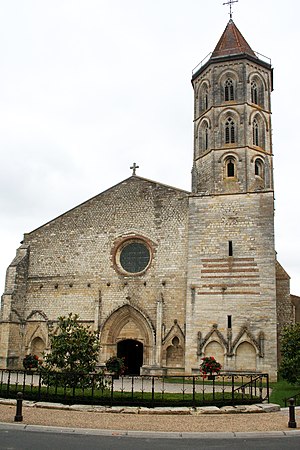
 Saint Laurent Church |
||
Fleurance is a French commune with 6021 inhabitants (as of January 1, 2017) in the Gers department in the Occitania region ; it belongs to the Arrondissement Condom and is the capital of the canton of Fleurance-Lomagne . Fleurance was the main town of the canton of Fleurance until 2015 .
geography
The medieval city, founded as a bastide , is located in Armagnac in the heart of the former province of Gascony . The name Fleurance is based on the Italian city of Florence . There are other similar references in the region to cities that were important across Europe at the time, such as Geaune (Genoa), Pavie (Pavia), Miélan (Milan), Barcelonne-du-Gers (Barcelona), Cologne (Gers) (Cologne) or Plaisance (Piacenza).
Neighboring municipalities of Fleurance are Castelnau-d'Arbieu in the north, Urdens in the northeast, Brugnens in the east, Céran and Lalanne in the southeast, Montestruc-sur-Gers in the south, Préchac and Réjaumont in the southwest, Sainte-Radegonde in the west and Pauilhac in the north.
Population development
| year | 1962 | 1968 | 1975 | 1982 | 1990 | 1999 | 2007 | 2017 |
| Residents | 4279 | 5174 | 5816 | 6088 | 6368 | 6273 | 6255 | 6021 |
Attractions
- Church of Saint-Laurent or Notre Dame et Saint Jean-Baptiste (1208–1406)
- Notre Dame de Fleurance church
